Geography of Bangladesh
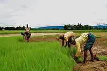
Bangladesh is a densely-populated, low-lying, mainly riverine country located in South Asia with a coastline of 580 km (360 mi) on the northern littoral of the Bay of Bengal. The delta plain of the Ganges (Padma), Brahmaputra (Jamuna), and Meghna Rivers and their tributaries occupy 79 percent of the country. Four uplifted blocks (including the Madhupur and Barind Tracts in the centre and northwest) occupy 9 percent and steep hill ranges up to approximately 1,000 metres (3,300 ft) high occupy 12 percent in the southeast (the Chittagong Hill Tracts) and in the northeast. Straddling the Tropic of Cancer, Bangladesh has a tropical monsoon climate characterised by heavy seasonal rainfall, high temperatures, and high humidity. Natural disasters such as floods and cyclones accompanied by storm surges periodically affect the country. Most of the country is intensively farmed, with rice the main crop, grown in three seasons. Rapid urbanisation is taking place with associated industrial and commercial development. Exports of garments and shrimp plus remittances from Bangladeshis working abroad provide the country's three main sources of foreign exchange income.
Physical geography
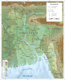
The physical geography of Bangladesh is varied and has an area characterised by two distinctive features: a broad deltaic plain subject to frequent flooding, and a small hilly region crossed by swiftly flowing rivers. The country has an area of 148,460 square kilometres (57,320 sq mi) and extends 820 kilometres (510 mi) north to south and 600 kilometres (370 mi) east to west. Bangladesh is bordered on the west, north, and east by a 4,095 kilometres (2,545 mi) land frontier with India and, in the southeast, by a short land and water frontier (193 kilometres (120 mi)) with Burma (Myanmar). On the south is a highly irregular deltaic coastline of about 580 kilometres (360 mi), fissured by many rivers and streams flowing into the Bay of Bengal. The territorial waters of Bangladesh extend 12 nautical miles (22 km), and the exclusive economic zone of the country is 200 nautical miles (370 km).
Roughly 80% of the landmass is made up of fertile alluvial lowland called the Bangladesh Plain. The plain is part of the larger Plain of Bengal, which is sometimes called the Lower Gangetic Plain. Although altitudes up to 105 metres (344 ft) above sea level occur in the northern part of the plain, most elevations are less than 10 metres (33 ft) above sea level; elevations decrease in the coastal south, where the terrain is generally at sea level. With such low elevations and numerous rivers, water—and concomitant flooding—is a predominant physical feature. About 10,000 square kilometres (3,900 sq mi) of the total area of Bangladesh is covered with water, and larger areas are routinely flooded during the monsoon season.
The only exceptions to Bangladesh's low elevations are the Chittagong Hills in the southeast, the Low Hills of Sylhet in the northeast, and highlands in the north and northwest. The Chittagong Hills constitute the only significant hill system in the country and, in effect, are the western fringe of the north–south mountain ranges of Burma and eastern India. The Chittagong Hills rise steeply to narrow ridge lines, generally no wider than 36 metres (118 ft), with altitudes from 600 to 900 metres (2,000 to 3,000 ft) above sea level. At 1,052 metres (3,451 ft) altitude, the highest elevation in Bangladesh is found at Saka Haphong, in the southeastern part of the hills. Fertile valleys lie between the hill lines, which generally run north–south. West of the Chittagong Hills is a broad plain, cut by rivers draining into the Bay of Bengal, that rises to a final chain of low coastal hills, mostly below 200 metres (660 ft), that attain a maximum elevation of 350 metres (1,150 ft). West of these hills is a narrow, wet coastal plain located between the cities of Chittagong in the north and Cox's Bazar in the south.
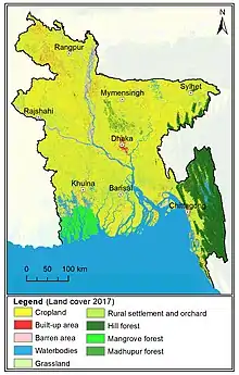
About 67% of Bangladesh's nonurban land is arable. Permanent crops cover only 2%, meadows and pastures cover 4%, and forests and woodland cover about 16%. The country produces large quantities of quality timber, bamboo, and sugarcane. Bamboo grows in almost all areas, but high-quality timber grows mostly in the highland valleys. Rubber planting in the hilly regions of the country was undertaken in the 1980s, and rubber extraction had started by the end of the decade. A variety of wild animals are found in the forest areas, such as in the Sundarbans on the southwest coast, which is the home of the royal Bengal tiger. The alluvial soils in the Bangladesh Plain are generally fertile and are enriched with heavy silt deposits carried downstream during the rainy season.
Human geography
Urbanisation is proceeding rapidly, and it is estimated that only 30% of the population entering the labour force in the future will be absorbed into agriculture, although many will likely find other kinds of work in rural areas. The areas around Dhaka and Comilla are the most densely settled. The Sundarbans, an area of coastal tropical jungle in the southwest and last wild home of the Bengal tiger, and the Chittagong Hill Tracts on the southeastern border with Burma and India, are the least densely populated.
Climate
Bangladesh has a tropical monsoon climate characterised by wide seasonal variations in rainfall, high temperatures, and high humidity. Regional climatic differences in this flat country are minor. Three seasons are generally recognised: a hot, muggy summer from March to June; a hot, humid and rainy monsoon season from June to November; and a warm-hot, dry winter from December to February. In general, maximum summer temperatures range between 38 and 41 °C (100.4 and 105.8 °F). April is the hottest month in most parts of the country. January is the coolest month, when the average temperature for most of the country is 16–20 °C (61–68 °F) during the day and around 10 °C (50 °F) at night.
Winds are mostly from the north and northwest in the winter, blowing gently at 1 to 3 kilometres per hour (0.6 to 1.9 mph) in northern and central areas and 3 to 6 kilometres per hour (1.9 to 3.7 mph) near the coast. From March to May, violent thunderstorms, called northwesters by local English speakers, produce winds of up to 60 kilometres per hour (37.3 mph). During the intense storms of the early summer and late monsoon season, southerly winds of more than 160 kilometres per hour (99.4 mph) cause waves to crest as high as 6 metres (19.7 ft) in the Bay of Bengal, which brings disastrous flooding to coastal areas.
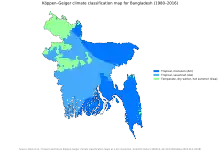
Heavy rainfall is characteristic of Bangladesh causing it to flood every year. Except for the relatively dry western region of Rajshahi, where the annual rainfall is about 1,600 mm (63.0 in), most parts of the country receive at least 2,300 mm (90.6 in) of rainfall per year. Because of its location just south of the foothills of the Himalayas, where monsoon winds turn west and northwest, the region of Sylhet in northeastern Bangladesh receives the greatest average precipitation. From 1977 to 1986, annual rainfall in that region ranged between 3,280 and 4,780 mm (129.1 and 188.2 in) per year. Average daily humidity ranged from March lows of between 55 and 81% to July highs of between 94 and 100%, based on readings taken at selected stations nationwide in 1986.
About 80% of Bangladesh's rain falls during the monsoon season. The monsoons result from the contrasts between low and high air pressure areas that result from differential heating of land and water. During the hot months of April and May hot air rises over the Indian subcontinent, creating low-pressure areas into which rush cooler, moisture-bearing winds from the Indian Ocean. This is the southwest monsoon, commencing in June and usually lasting through September. Dividing against the Indian landmass, the monsoon flows in two branches, one of which strikes western India. The other travels up the Bay of Bengal and over eastern India and Bangladesh, crossing the plain to the north and northeast before being turned to the west and northwest by the foothills of the Himalayas.
Natural calamities, such as floods, tropical cyclones, tornadoes, and tidal bores—destructive waves or floods caused by flood tides rushing up estuaries—ravage the country, particularly the coastal belt, almost every year. Between 1947 and 1988, 13 severe cyclones hit Bangladesh, causing enormous loss of life and property. In May 1985, for example, a severe cyclonic storm packing 154-kilometre-per-hour (95.7 mph) winds and waves 4 metres (13.1 ft) high swept into southeastern and southern Bangladesh, killing more than 11,000 persons, damaging more than 94,000 houses, killing some 135,000 head of livestock, and damaging nearly 400 kilometres (248.5 mi) of critically needed embankments.
Annual monsoon flooding results in the loss of human life, damage to property and communication systems, and a shortage of drinking water, which leads to the spread of disease. For example, in 1988 two-thirds of Bangladesh's 64 districts experienced extensive flood damage in the wake of unusually heavy rains that flooded the river systems. Millions were left homeless and without potable water. Half of Dhaka, including the runway at the Shahjalal International Airport—an important transit point for disaster relief supplies—was flooded. About 2,000,000 tonnes (2,204,623 short tons; 1,968,413 long tons) of crops were reported destroyed, and relief work was rendered even more challenging than usual because the flood made transportation exceedingly difficult. A tornado in April 1989 killed more than 600 people, possibly many more.
There are no precautions against cyclones and tidal bores except giving advance warning and providing safe public buildings where people may take shelter. Adequate infrastructure and air transport facilities that would ease the sufferings of the affected people had not been established by the late 1980s. Efforts by the government under the Third Five-Year Plan (1985–90) were directed toward accurate and timely forecast capability through agrometeorology, marine meteorology, oceanography, hydrometeorology, and seismology. Necessary expert services, equipment, and training facilities were expected to be developed under the United Nations Development Programme.
Cold weather is unusual in Bangladesh. When temperatures decrease to 8 °C (46 °F) or less, people without warm clothing and living in inadequate homes may die from the cold.[3][4][5]
Climate Change
Climate change in Bangladesh is a critical issue as the country is one of the most vulnerable to the effects of climate change.[6][7] In the 2020 edition of Germanwatch's Climate Risk Index, it ranked seventh in the list of countries most affected by climate calamities during the period 1999–2018.[8] Bangladesh's vulnerability to climate change impacts is due to a combination of geographical factors, such as its flat, low-lying, and delta-exposed topography,[9] and socio-economic factors, including its high population density, levels of poverty, and dependence on agriculture.[10]
Factors such as frequent natural disasters, lack of infrastructure, high population density (166 million people living in an area of 147,000 km2 [11]), an extractivist economy and social disparities are increasing the vulnerability of the country in facing the current changing climatic conditions. Almost every year large regions of Bangladesh suffer from more intense events like cyclones, floods and erosion. The mentioned adverse events are slowing the development of the country by bringing socio-economical and environmental systems to almost collapse.[11]
Natural hazards that come from increased rainfall, rising sea levels, and tropical cyclones are expected to increase as the climate changes, each seriously affecting agriculture, water and food security, human health, and shelter.[12] Sea levels in Bangladesh are predicted to rise by up to 0.30 metres by 2050, resulting in the displacement of 0.9 million people, and by up to 0.74 metres by 2100, resulting in the displacement of 2.1 million people.[13]River systems
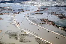
.jpg.webp)
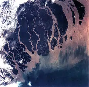
The rivers of Bangladesh mark both the physiography of the nation and the life of the people. About 700 in number, these rivers generally flow south. The larger rivers serve as the main source of water for cultivation and as the principal arteries of commercial transportation. Rivers also provide fish, an important source of protein. Flooding of the rivers during the monsoon season causes enormous hardship and hinders development, but fresh deposits of rich silt replenish the fertile but overworked soil. The rivers also drain excess monsoon rainfall into the Bay of Bengal. Thus, the great river system is at the same time the country's principal resource and its greatest hazard.
The profusion of rivers can be divided into five major networks. The Jamuna-Brahmaputra is 292 kilometres (181 mi) long and extends from northern Bangladesh to its confluence with the Padma. Originating as the Yarlung Tsangpo River in China's Xizang Autonomous Region (Tibet) and flowing through India's state of Arunachal Pradesh, where it becomes known as the Brahmaputra ("Son of Brahma"), it receives waters from five major tributaries that total some 740 kilometres (460 mi) in length. At the point where the Brahmaputra meets the Tista River in Bangladesh, it becomes known as the Jamuna. The Jamuna is notorious for its shifting subchannels and for the formation of fertile silt islands (chars). No permanent settlements can exist along its banks.
The second system is the Padma-Ganges, which is divided into two sections: a 258 kilometres (160 mi) segment, the Ganges, which extends from the western border with India to its confluence with the Jamuna some 72 kilometres (45 mi) west of Dhaka, and a 126 kilometres (78 mi) segment, the Padma, which runs from the Ganges-Jamuna confluence to where it joins the Meghna River at Chandpur. The Padma-Ganges is the central part of a deltaic river system with hundreds of rivers and streams—some 2,100 kilometres (1,300 mi) in length—flowing generally east or west into the Padma.
The third network is the Surma-Meghna River System, which courses from the northeastern border with India to Chandpur, where it joins the Padma. The Surma-Meghna, at 669 kilometres (416 mi) by itself the longest river in Bangladesh, is formed by the union of six lesser rivers. Below the city of Kalipur it is known as the Meghna. When the Padma and Meghna join together, they form the fourth river system—the Padma-Meghna—which flows 145 kilometres (90 mi) to the Bay of Bengal.
This mighty network of four river systems flowing through the Bangladesh Plain drains an area of some 1.5 million square kilometres (580,000 sq mi). The numerous channels of the Padma-Meghna, its distributaries, and smaller parallel rivers that flow into the Bay of Bengal are referred to as the Mouths of the Ganges. Like the Jamuna, the Padma-Meghna and other estuaries on the Bay of Bengal are also known for their many chars.
.jpg.webp)
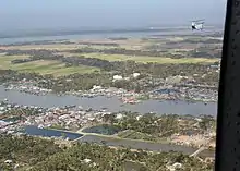
A fifth river system, unconnected to the other four, is the Karnaphuli. Flowing through the region of Chittagong and the Chittagong Hills, it cuts across the hills and runs rapidly downhill to the west and southwest and then to the sea. The Feni, Karnaphuli, Sangu, and Matamuhari—an aggregate of some 420 kilometres (260 mi)—are the main rivers in the region. The port of Chittagong is situated on the banks of the Karnaphuli. The Karnaphuli Reservoir and Karnaphuli Dam are located in this area. The dam impounds the Karnaphuli River's waters in the reservoir for the generation of hydroelectric power.
The Ganga–Brahmaputra rivers contribute nearly 1000 million tons/yr of sediment. The sediment contributed from these two rivers forms the Bengal Delta and Submarine fan, a vast structure that extends from Bangladesh to south of the Equator which is up to 16.5 km thick, and contains at least 1130 trillion tonnes of sediment accumulating over the last 17 million years at an average rate of 665 million tons/yr.[14] The Bay of Bengal used to be deeper than the Mariana Trench, the present deepest ocean point.
During the annual monsoon period, the rivers of Bangladesh flow at about 140,000 cubic metres per second (4,900,000 cu ft/s), but during the dry period they diminish to 7,000 cubic metres per second (250,000 cu ft/s). Because water is so vital to agriculture, more than 60% of the net arable land, some 91,000 square kilometres (35,000 sq mi), is cultivated in the rainy season despite the possibility of severe flooding, and nearly 40% of the land is cultivated during the dry winter months. Water resources development has responded to this "dual water regime" by providing flood protection, drainage to prevent over flooding and water logging, and irrigation facilities for the expansion of winter cultivation. Major water control projects have been developed by the national government to provide irrigation, flood control, drainage facilities, aids to river navigation and road construction, and hydroelectric power. In addition, thousands of tube wells and electric pumps are used for local irrigation. Despite severe resource constraints, the government of Bangladesh has made it a policy to try to bring additional areas under irrigation without salinity intrusion.
Water resources management, including gravity flow irrigation, flood control, and drainage, were largely the responsibility of the Bangladesh Water Development Board. Other public sector institutions, such as the Bangladesh Krishi Bank, the Bangladesh Rural Development Board, the Bangladesh Bank, and the Bangladesh Agricultural Development Corporation were also responsible for promotion and development of minor irrigation works in the private sector through government credit mechanisms.
Coastal systems
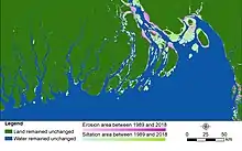
Bangladesh coastal areas are covering the south part of Bangladesh. The main rivers of Bangladesh derived from the Himalayas carry a high level of sediment and deposit it across the Bay of Bengal. This has led to major changes in the coastal region between 1989 and 2018. Over 30 years morphological changes many islands are losing land area. However, there has been an overall net gain in the land area due to the regular acceleration process in other parts of those islands. In the west, new islands were found, but no significant changes were observed. At the mouth of the Meghna estuary, noticeable variable changes have been observed with the formation of many new islands.
In 1989, the land area was only 28835 km2 (56.06%), while the water area was 22600 km2 (43.94%) with the region falling among 20° 34’ N to 26°38 N and 88° 01’ N to 92° 41’ E, and with an area of 147,570 km2. In 2018, the land area increased to 29426 km2 (57.21%); an increase of 590 km2 (1.15%). The land area in 1999 and 2009 was 56.49% and 56.68%, respectively, with a total increase of 0.19%. The island reformation tendency showed that the new land area increased every year by an average of 20 km2 (0.038) along the coastal region of Bangladesh. Plant growth has been observed in the newly formed islands over a period of 30 years. In the early stages, the islands are usually muddy waste areas that gradually changed into grasslands and trees.[16]
Area and boundaries
Area:
total: 148,460 km2
country comparison to the world: 95
land: 130,170 km2
water: 18,290 km2
Land boundaries:
total: 4,413 km
border countries: Myanmar 271 km, India 4,142 km
Coastline: 580 km
Maritime claims:
territorial sea: 12 nmi (22.2 km; 13.8 mi)[17]
contiguous zone: 18 nmi (33.3 km; 20.7 mi)
exclusive economic zone: 200 nmi (370.4 km; 230.2 mi)
continental shelf: up to the outer limits of the continental margin
Elevation extremes:
lowest point: Indian Ocean 0 m
highest point: In the Mowdok range at 1052 m (at N 21°47'12" E 92°36'36"), NOT Keokradong (883 m not 1,230 m) or Tajingdong (985 m not 1,280 m as sometimes reported)
Resources and land use
Natural resources: natural gas, arable land, timber, coal
Land use:
Arable land: 58.96%
Permanent crops: 6.53%
other: 34.51% (2012)
Irrigated land: 50,000 km2 (2008)
Total renewable water resources: 1,227 km3 (2011)
Freshwater withdrawal (domestic/industrial/agricultural):
total: 35.87 km3/yr (10%/2%/88%)
per capita: 238.3 m3/yr (2008)
Environmental concerns
Natural hazards: Much of the country is submerged by floodwater in the monsoon season (and traditional settlements and agriculture are adapted to this); damaging floods occur when rivers rise higher than normal; tropical cyclones (hurricanes) and storm surges; droughts; riverbank erosion along the country's major rivers and in the Meghna estuary; earthquakes; possibly tsunamis.
Environment – current issues: Country very densely populated (1,125 per km2); rapid urbanisation taking place; many people landless, and many live on and cultivate land exposed to floods, riverbank erosion or cyclones; groundwater used for drinking water and irrigation is widely contaminated with naturally-occurring arsenic in some floodplain areas; water-borne diseases prevalent; surface water widely polluted by industrial, agricultural and urban effluents, affecting domestic supplies and inland fisheries; intermittent water shortages because of falling water tables in some northern and central parts of the country; increasing water and soil salinity in some coastal areas, especially in the south-west, due to abstraction of river and groundwater upstream; soil degradation due to intensive cropping, depletion of organic matter and unbalanced use of fertilisers; deforestation and soil erosion in hill areas.
Environment – international agreements:
party to:
Biodiversity, Climate Change, Climate Change-Kyoto Protocol, Desertification, Endangered Species, Environmental Modification, Hazardous Wastes, Law of the Sea, Ozone Layer Protection, Ship Pollution, Wetlands
See also
References
- Uddin, Kabir; Matin, Mir A.; Meyer, Franz J. (January 2019). "Operational Flood Mapping Using Multi-Temporal Sentinel-1 SAR Images: A Case Study from Bangladesh". Remote Sensing. 11 (13): 1581. doi:10.3390/rs11131581.
- NASA/Goddard Space Flight Center, Scientific Visualization Studio (18 April 2002). "Himalayas Exaggerated (version 2.2)" (MPEG). Retrieved 30 April 2007.
- "Cold Wave Kills 102 People in Bangladesh". Los Angeles Times. 6 January 1995. p. 6. Retrieved 4 February 2015.
Temperatures plunged to 39 degrees this week in northern Bangladesh, killing people too poor to afford jackets or sweaters. It was the lowest temperature recorded in Bangladesh since 1964, when the temperature dropped to 38 degrees.
- "33 in Northern Bangladesh Are Reported Killed by Cold". The New York Times. Associated Press. 29 December 1989. p. A3. Retrieved 4 February 2015.
A cold wave in normally tropical northern Bangladesh has killed at least 33 people in the last week, a newspaper reported today. Temperatures in the region have hovered around 42 °F (6 °C) since Monday, and the newspaper said the victims were laborers and other poor people who were unable to protect themselves from the cold.
- "Hundreds Dead in Bangladeshi Cold Spell". The Washington Post. 6 January 1998. p. A14.
In northern Bangladesh, temperatures dipped to 46 degrees Sunday, the Independent newspaper said. Although the temperature was above freezing, it was cold enough to kill people in tropical Bangladesh, where half the population of 120 million people can't afford enough food or warm clothes.
- Kulp, Scott A.; Strauss, Benjamin H. (29 October 2019). "New elevation data triple estimates of global vulnerability to sea-level rise and coastal flooding". Nature Communications. 10 (1): 4844. Bibcode:2019NatCo..10.4844K. doi:10.1038/s41467-019-12808-z. ISSN 2041-1723. PMC 6820795. PMID 31664024.
- "Report: Flooded Future: Global vulnerability to sea level rise worse than previously understood". climatecentral.org. 29 October 2019. Retrieved 3 November 2019.
- Kreft, Sönke; David Eckstein, David; Melchior, Inga (December 2019). Global Climate Risk Index 2020 (PDF). Bonn: Germanwatch e.V. ISBN 978-3-943704-77-8. Archived (PDF) from the original on 25 December 2019. Retrieved 9 December 2020.
- Ayers, Jessica; Huq, Saleemul; Wright, Helena; Faisal, Arif M.; Hussain, Syed Tanveer (2 October 2014). "Mainstreaming climate change adaptation into development in Bangladesh". Climate and Development. 6 (4): 293–305. doi:10.1080/17565529.2014.977761. ISSN 1756-5529.
- Thomas TS, Mainuddin K, Chiang C, Rahman A, Haque A, Islam N, Quasem S, Sun Y (2013). Agriculture and Adaptation in Bangladesh: Current and Projected Impacts of Climate Change (PDF) (Report). IFPRI. Retrieved 26 November 2020.
- "Bangladesh Population 2018 (Demographics, Maps, Graphs)". worldpopulationreview.com. Retrieved 19 June 2018.
- Bangladesh Climate Change Strategy and Action Plan, 2008 (PDF). Ministry of Environment and Forests Government of the People's Republic of Bangladesh. 2008. ISBN 978-984-8574-25-6. Archived from the original (PDF) on 7 October 2009.
- Davis, Kyle Frankel; Bhattachan, Abinash; D’Odorico, Paolo; Suweis, Samir (1 June 2018). "A universal model for predicting human migration under climate change: examining future sea level rise in Bangladesh". Environmental Research Letters. 13 (6): 064030. Bibcode:2018ERL....13f4030F. doi:10.1088/1748-9326/aac4d4. ISSN 1748-9326.
- Wasson, Robert (2003). "A sediment budget for the Ganga–Brahmaputra catchment" (PDF). Current Science. 84 (8): 1041–1047.
- "Coastal morphological changes: Assessing long-term ecological transformations across the northern Bay of Bengal". Environmental Challenges. 1: 100001. December 2020. doi:10.1016/j.envc.2020.100001. ISSN 2667-0100.
- Uddin, Kabir; Nishanta, Khanal; Sunita, Chaudhary; Sajana, Maharjan; Rajesh Bahadur, Thapa (1 December 2020). "Coastal morphological changes: Assessing long-term ecological transformations across the northern Bay of Bengal". Environmental Challenges. 1: 100001. doi:10.1016/j.envc.2020.100001. ISSN 2667-0100.
- "South Asia :: Bangladesh — The World Factbook". Central Intelligence Agency. Retrieved 1 August 2020.
- Attribution
 This article incorporates public domain material from the Library of Congress Country Studies website http://lcweb2.loc.gov/frd/cs/.
- This article incorporates public domain material from the CIA World Factbook website https://www.cia.gov/the-world-factbook/.
- This article incorporates public domain material from the United States Department of State website https://www.state.gov/countries-areas/. (U.S. Bilateral Relations Fact Sheets)
Further reading
- Bangladesh Bureau of Statistics Yearbook of Bangladesh (published periodically on-line).
- Brammer, H.T (2012). he Physical Geography of Bangladesh. Dhaka, Bangladesh: University Press. ISBN 978-984-506-049-3.
- Rashid, Haroun Er (1991). Geography of Bangladesh. Dhaka, Bangladesh: University Press. ISBN 978-984-05-1159-4.
External links
| Sovereign states |
|
|---|---|
| States with limited recognition |
|
| Dependencies and other territories |
|
| |