Kashmir Valley
The Kashmir Valley, also known as the Vale of Kashmir, is an intermontane valley in Kashmir; it is in the portion of the Kashmir region administered by India. The valley is bounded on the southwest by the Pir Panjal Range and on the northeast by the main Himalayas range. It is approximately 135 km (84 mi) long and 32 km (20 mi) wide, and drained by the Jhelum River.[1]
| Kashmir Valley | |
|---|---|
| Vale of Kashmir | |
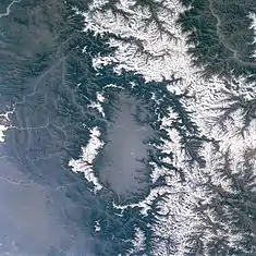 Satellite imagery of the Kashmir Valley, showcasing the snow-capped peaks of the Pir Panjal Range (left in image; southwest in compass) and the Himalayas (right in image; northeast in compass) flanking it on either side | |
 The Kashmir valley shown in the southwestern region of the larger Kashmir region | |
| Length | 83 miles (134 km) Northwest-Southeast |
| Width | 20 miles (32 km) |
| Geography | |
| Country | Region of Kashmir administered by India as the Union territory of Jammu and Kashmir |
| River | Jhelum |
Climate
The Kashmir Valley has a moderate climate, which is largely defined by its geographic location, with the towering Karakoram Range in the north, Pir Panjal Range in the south and west and Zanskar Range in the east.[2] It can be generally described as cool in the spring and autumn, mild in the summer and cold in the winter. As a large valley with significant differences in geo-location among various districts, the weather is often cooler in the hilly areas compared to the flat lower parts.
Summer is usually mild and fairly dry, but relative humidity is generally high and the nights are cool. Precipitation occurs throughout the year and no month is particularly dry. The hottest month is July (mean minimum temperature 16 °C, mean maximum temperature 32 °C) and the coldest are December–January (mean minimum temperature −15 °C, mean maximum temperature 0 °C).
Compared with other plain parts of India, the Kashmir Valley enjoys a more moderate climate but weather conditions are unpredictable. The recorded high temperature is 33 °C and the recorded low is −18 °C. On 5 and 6 January 2012, after years of relatively little snow, a wave of heavy snow and low temperatures (winter storm) shocked the valley covering it in a thick layer of snow and ice.
The Valley has seen an increase in relative humidity and annual precipitation in the last few years. This is most likely because of the commercial afforestation projects which also include expanding parks and green cover.
| Srinagar | ||||||||||||||||||||||||||||||||||||||||||||||||||||||||||||
|---|---|---|---|---|---|---|---|---|---|---|---|---|---|---|---|---|---|---|---|---|---|---|---|---|---|---|---|---|---|---|---|---|---|---|---|---|---|---|---|---|---|---|---|---|---|---|---|---|---|---|---|---|---|---|---|---|---|---|---|---|
| Climate chart (explanation) | ||||||||||||||||||||||||||||||||||||||||||||||||||||||||||||
| ||||||||||||||||||||||||||||||||||||||||||||||||||||||||||||
| ||||||||||||||||||||||||||||||||||||||||||||||||||||||||||||
Transport
The Kashmir Valley is connected to the Jammu Division and Ladakh by both road and air. It has access to the Jammu Division and the rest of India through a road tunnel in Banihal near Qazigund via National Highway 1A and through 1B that passes through the Sinthan top mountain pass and Kishtwar municipality.
Sheikh ul-Alam International Airport (SXR) is the main airport in the Kashmir Valley, located in Srinagar, and has scheduled flights from Jammu, Leh, Mumbai, Chandigarh and New Delhi. The Valley has a 119 km (74 mi)-long modern railway line that began operations in October 2009; it connects Baramulla (in the western part of the Valley) to Srinagar and Qazigund. Since 26 June 2013, the railway line further links the Kashmir Valley to Banihal—located across the Pir Panjal Range—through the new 11 km (6.8 mi)-long Pir Panjal Railway Tunnel. The railway station in Banihal is expected to be linked to the rest of India as construction on the railway line progresses. Other airports in the Indian-administered union territory are located in Udhampur and Jammu, while there is a proposal for an airport to be constructed in Anantnag.
Kashmir Division
Kashmir Division | |
|---|---|
Administrative Division | |
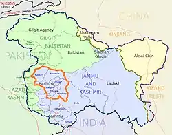 Kashmir Division (bordered orange) shown within the wider Kashmir region | |
| Country | India |
| Union territory | Jammu and Kashmir |
| Districts | Anantnag, Baramulla, Budgam, Bandipore, Ganderbal, Kupwara, Kulgam, Pulwama, Shopian and Srinagar. |
| Headquarters | Srinagar |
| Historical divisions | |
| Government | |
| • Type | Division |
| • Divisional Commissioner | Pandurang Kondbarao Pole |
| Area | |
| • Total | 15,948 km2 (6,158 sq mi) |
| Dimensions | |
| • Length | 135[1] km (83.885 mi) |
| • Width | 32[1] km (19.884 mi) |
| Elevation | 1,620[1] m (5,314 ft) |
| Population (2011[5]) | |
| • Total | 6,907,622[5] |
| • Density | 450.06/km2 (1,165.7/sq mi) |
| Demonym(s) | Kashmiris, Koshur |
| Ethnicity and language | |
| • Languages | Kashmiri, Urdu, Hindi,[6] English,[7] Pahari people (Kashmir), Gojri, Shina |
| • Ethnic groups | Kashmiri, Pahari people, Gujar, Shina |
| • Religion (2011[8]) | 96.41% Islam, 2.45% Hinduism, 0.81% Sikhism, 0.17% Christianity |
| Time zone | UTC+5:30 (IST) |
| Vehicle registration | JK |
| Highest peak | Machoi Peak (5458 metres) |
| Largest lake | Wular lake(260 km2 (100 sq mi))[9] |
| Longest river | Jhelum river(725 kilometres)[10] |
| Website | http://kashmirdivision.nic.in/ |
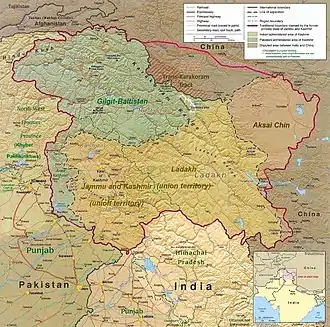
The Kashmir Division is a revenue and administrative division of Indian-administered Jammu and Kashmir. It borders Jammu Division to the south and the Indian-administered union territory of Ladakh to the east, while the Line of Control forms its border with the Pakistani-administered territories of Azad Jammu and Kashmir and Gilgit−Baltistan to the north and west, respectively.
The Indian administrative districts for the Kashmir Valley were reorganised in 1968,[11] and 2006,[12] each time subdividing existing districts. Kashmir Division currently consists of the following ten districts:
| Name of district |
HQ | Area | Population[13] | |||||
|---|---|---|---|---|---|---|---|---|
| Total (km2) |
Total (sq mile) |
Rural (km2) |
Urban (km2) |
2001 census |
2011 census | |||
| Anantnag | Anantnag | 3,574 | 1,380 | 3,475.8 | 98.2 | [14] | 778,408 | 1,070,144 |
| Kulgam | Kulgam | 410 | 158 | 360.2 | 49.8 | [15] | 394,026 | 422,786 |
| Pulwama | Pulwama | 1,086 | 419 | 1,047.5 | 38.6 | [16] | 441,275 | 570,060 |
| Shopian | Shopian | 312 | 120 | 306.6 | 5.4 | [17] | 211,332 | 265,960 |
| Budgam | Budgam | 1,361 | 525 | 1,312.0 | 49.1 | [18] | 607,181 | 735,753 |
| Srinagar | Srinagar | 1,979 | 764 | 1,684.4 | 294.5 | [19] | 1,027,670 | 1,269,751 |
| Ganderbal | Ganderbal | 259 | 100 | 233.6 | 25.4 | [20] | 217,907 | 297,003 |
| Bandipore | Bandipore | 345 | 133 | 295.4 | 49.6 | [21] | 304,886 | 385,099 |
| Baramulla | Baramulla | 4,243 | 1,638 | 4,179.4 | 63.6 | [22] | 843,892 | 1,015,503 |
| Kupwara | Kupwara | 2,379 | 919 | 2,331.7 | 47.3 | [23] | 650,393 | 875,564 |
| Total | 15,948 | 6,158 | 15,226.4 | 721.5 | 5,476,970 | 6,907,623 | ||
Srinagar is its main city and also the summer capital of the Jammu and Kashmir. Other main cities are Baramulla, Anantnag, Pulwama.
Notes
References
- "Vale of Kashmir | valley, India". Encyclopædia Britannica. Archived from the original on 4 August 2016. Retrieved 8 July 2016.
- Sharad Singh Negi (1986). Geo-botany of India. Periodical Expert Book Agency, 1986. p. 58–. ISBN 9788171360055. Retrieved 11 July 2012.
- "Climatological Information for Srinagar, India". Hong Kong Observatory. Archived from the original on 6 April 2012. Retrieved 9 June 2012.
- "Spoken Kashmiri: A Language Course". Archived from the original on 29 November 2016. Retrieved 1 February 2017.
- "Demography of Jammu and Kashmir State". J&K; Envis Centre, Department of Ecology Environment and Remote Sensing J&K. Archived from the original on 22 February 2018. Retrieved 18 December 2016.
This used the Digest of Statistics, 2011-12 for its data source. - "The Jammu and Kashmir Official Languages Act, 2020" (PDF). The Gazette of India. Retrieved 27 September 2020.
- "Parliament passes JK Official Languages Bill, 2020". Rising Kashmir. 23 September 2020. Retrieved 23 September 2020.
- "Religion Data of Census 2011: XV Jammu and Kashmir", Centre for Policy Studies, India, Chennai and Delhi, 29 February 2016, archived from the original on 24 January 2021
- "Wular Lake | lake, India". Encyclopædia Britannica. Archived from the original on 2 February 2017. Retrieved 1 February 2017.
- "Jhelum River | river, Asia". Encyclopædia Britannica. Archived from the original on 2 February 2017. Retrieved 1 February 2017.
- Behera, Navnita Chadha (2006). Demystifying Kashmir. Pearson Education India. p. 28. ISBN 978-8131708460.
- "Jammu and Kashmir to have eight new districts". Indo-Asian News Service. 6 July 2006.
- Census of India 2011, Provisional Population Totals Paper 1 of 2011 : Jammu & Kashmir. Office of the Registrar General & Census Commissioner, India (Report).
Annexure V, Ranking of Districts by Population Size, 2001 - 2011 (Report). - District Census Handbook Anantnag, Part A (PDF). Census of India 2011 (Report). July 2016. p. 9. Retrieved 21 November 2020.
District Census Handbook Anantnag, Part B (PDF). Census of India 2011 (Report). July 2016. pp. 12, 22. Retrieved 21 November 2020. - District Census Handbook Kulgam, Part A (PDF). Census of India 2011 (Report). July 2016. p. 10. Retrieved 21 November 2020.
District Census Handbook Kulgam, Part B (PDF). Census of India 2011 (Report). 16 June 2014. pp. 12, 22. Retrieved 21 November 2020.
Part B page 12 says the are of the district is 404 sq km, but page 22 says 410 sq km. - District Census Handbook Pulwama, Part B (PDF). Census of India 2011 (Report). 16 June 2014. pp. 12, 22. Retrieved 21 November 2020.
- District Census Handbook Shupiyan, Part A (PDF). Census of India 2011 (Report). 16 June 2014. p. 10. Retrieved 21 November 2020.
District Census Handbook Shupiyan, Part B (PDF). Census of India 2011 (Report). 16 June 2014. pp. 12, 22. Retrieved 21 November 2020.
Part B pages 12 and 22 say the district area is 312.00 sq km, but Part A page 10 says 307.42 sq km. - District Census Handbook Badgam, Part A (PDF). Census of India 2011 (Report). July 2016. pp. 10, 46. Retrieved 21 November 2020.
District Census Handbook Badgam, Part B (PDF). Census of India 2011 (Report). 16 June 2014. pp. 11, 12, 22. Retrieved 21 November 2020.
Part A says the district area is 1371 sq km, Part B says 1371 sq km (page 11) and 1361 sq km (page 12s and 22). - District Census Handbook Srinagar, Part A (PDF). Census of India 2011 (Report). July 2016. pp. 11, 48. Retrieved 21 November 2020.
Part A page 48 says the district area was 2228.0 sq km in 2001 and 1978.95 sq km in 2011. - District Census Handbook Ganderbal, Part B (PDF). Census of India 2011 (Report). July 2016. pp. 11, 12 and 22. Retrieved 21 November 2020.
Part B page 11 says the district area is 393.04 sq km, but pages 12 and 22 say 259.00 sq km. - District Census Handbook Bandipora, Part A (PDF). Census of India 2011 (Report). July 2016. pp. 10, 47. Retrieved 21 November 2020.
District Census Handbook Bandipora, Part B (PDF). Census of India 2011 (Report). 16 June 2014. pp. 11, 20. Retrieved 21 November 2020. - District Census Handbook Baramulla, Part A (PDF). Census of India 2011 (Report). July 2016. p. 11. Retrieved 21 November 2020.
District Census Handbook Baramulla, Part B (PDF). Census of India 2011 (Report). 16 June 2014. p. 22. Retrieved 21 November 2020. - District Census Handbook Kupwara, Part A (PDF). Census of India 2011 (Report). July 2016. p. 7. Retrieved 21 November 2020.
District Census Handbook Kupwara, Part B (PDF). Census of India 2011 (Report). 16 June 2014. pp. 11, 12. Retrieved 21 November 2020.
External links
- Kashmir Division Administration
- Kashmir Divisional Commissioner
 Kashmir Valley travel guide from Wikivoyage
- "Vale of Kashmir", Encyclopædia Britannica
| Passes |  | |
|---|---|---|
| Valleys | ||
| Cities | ||
| Towns |
| |
| Rivers | ||
| Glaciers | ||
| Lakes | ||
| Mountains | ||
| Hill stations and Mughal gardens | ||
| Protected Areas | ||
| See also | ||