Geography of Afghanistan
Afghanistan is a landlocked mountainous country located within Central and South Asia, also sometimes included as part of the Middle East.[6][7] The country is the 40th largest in the world in size. Kabul is the capital and largest city of Afghanistan, located in the Kabul Province. Strategically located at the crossroads of major trade routes, Afghanistan has attracted a succession of invaders since the sixth century BCE.[8]
 | |
| Continent | Asia |
|---|---|
| Region | Central Asia |
| Coordinates | 33°00′N 65°00′E |
| Area | Ranked 42nd |
| • Total | 647,230 km2 (249,900 sq mi) |
| Coastline | 0 km (0 mi) |
| Borders | Pakistan 2,670 km (1,660 mi), Tajikistan 1,357 km (843 mi), Iran 921 km (572 mi), Turkmenistan 804 km (500 mi), Uzbekistan 144 km (89 mi), China 91 km (57 mi) |
| Highest point | Noshaq, 7,492 m (24,580 ft) |
| Lowest point | Amu Darya at Khamyab, 258 m (846 ft) |
| Longest river | Helmand River |
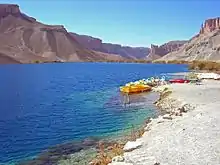
| Largest lake | Kajaki Dam Dahla Dam Naghlu Dam Band-e Amir Qargha |
| Climate | Arid to semiarid; cold winters and hot summers |
| Terrain | mostly low plateau with deserts, rangelands and a fertile plain in the southeast |
| Natural Resources | natural gas, petroleum, coal, copper, chromite, talc, barites, sulfur, lead, zinc, iron ore, salt, precious and semiprecious stone[1][2][3][4][5] |
| Natural Hazards | earthquakes, flooding, avalanches |
| Environmental Issues | limited fresh water, soil degradation, overgrazing, deforestation, desertification, air pollution, water pollution |
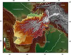
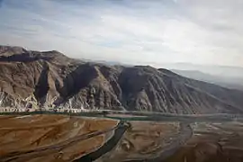
The Hindu Kush mountains, running northeast to southwest across the country, divide the nation into three major regions: 1) the Central Highlands, which account for roughly two thirds of the country's area; 2) the Southwestern Plateau, which accounts for one-fourth of the land; and 3) the smaller Northern Plains area, which contains the country's most fertile soil.
Land elevations generally slope from northeast to southwest, following the general shape of the Hindu Kush massif, from its highest point in the Pamir Mountains near the Chinese border to the lower elevations near the border with Uzbekistan. To the north, west, and southwest there are no mountain barriers to neighboring countries. The northern plains pass into the plains of Turkmenistan. In the west and southwest, the plateaus and deserts merge into those of Iran. Afghanistan is located on the Eurasian Tectonic Plate. The Wakhan Corridor and the rest of northeastern Afghanistan, including Kabul, are situated in a geologically active area. Over a dozen earthquakes occurred there during the twentieth century.
The greater part of the northern border and a small section of the border with Pakistan are marked by rivers; the remaining boundary lines are political rather than natural. The northern frontier extends approximately 1,689 km (1,049 mi) southwestward, from the Pamir Mountains in the northeast to a region of hills and deserts in the west, at the border with Iran. The border with Iran runs generally southward from the Hari River across swamp and desert regions before reaching the northwestern tip of Pakistan. Its southern section crosses the Helmand River.
Afghanistan is bounded by six countries. Its longest border is the Durand Line, accounting for its entire southern and eastern boundary with Pakistan. The shortest one, bordering China's Xinjiang province, is a mere 76 km (47 mi) at the end of the Wakhan Corridor (the Afghan Panhandle), a narrow sliver of land 241 km (150 mi) long that extends eastward between Tajikistan and Pakistan. At its narrowest point it is only 11 km (7 mi) wide.
The border with Pakistan runs eastward from Iran through the Chagai Hills and the southern end of the Registan Desert, then northward through mountains. It then follows an irregular northeasterly course before reaching the Durand Line, established in 1893. This line continues on through mountainous regions to the Khyber Pass area. Beyond this point it rises to the crest of the Hindu Kush, which it follows eastward to the Pamir Mountains. The Durand Line divides the Pashtun tribes of the region between Afghanistan and Pakistan. Its creation has caused much dissatisfaction among Afghans and has given rise to political tensions between the two countries.
Climate
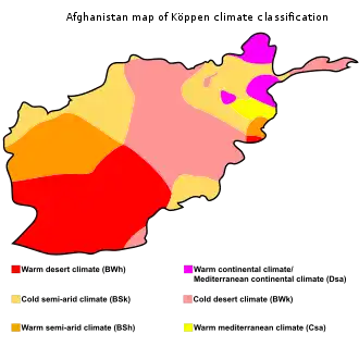
Rainfall in Afghanistan is very scarce, and mainly only affects the northern highlands, arriving in March and April. Rainfall in the more arid lowlands is rare, and can be very unpredictable.[9] Marked characteristics are the great differences of summer and winter temperature and of day and night temperature, as well as the extent to which change of climate can be attained by slight change of place. The Afghan climate is a dry one. The sun shines for three-fourths of the year, and the nights are clearer than the days.
Taking the highlands of the country as a whole, there is no great difference between the mean temperature of Afghanistan and that of the lower Himalaya. However, a remarkable feature of the Afghan climate is its extreme temperature range within limited periods. The smallest daily range in the north is when the weather is cold; the greatest is when it is hot. For seven months of the year (from May to November) this range exceeds 17 °C (63 °F) daily. Waves of intense cold occur, lasting for several days, and one may have to endure temperatures of −24 °C (−11 °F), rising to a maximum of −8 °C (18 °F). At Ghazni the snow has been known to stay long beyond the vernal equinox; the temperatures sink as low as −25 °C (−13 °F). Oral tradition tells the destruction of the entire population of Ghazni by snowstorms more than once. On the other hand, the summer temperature is exceedingly high, especially in the Oxus regions, where a shade maximum of 45–50 °C (113–122 °F) is not uncommon.
The summer heat is strong in the Sistan Basin, Jalalabad and Turkestan. The simoom wind occurs in Kandahar province during the summer. The hot season is rendered more intense by frequent dust storms and strong winds; whilst the bare rocky ridges that traverse the country, absorbing heat by day and radiating it by night, render the summer nights most oppressive. In Kabul the heat is tempered occasionally by cool breezes from the Hindu Kush, and the nights are usually cool. In Kandahar snow seldom falls on the plains or lower hills; when it does, it melts at once.
The summer rains that accompany the southwest monsoon in India, beat along the southern slopes of the Himalaya, and travel up the Kabul valley as far as Laghman, though they are more clearly felt in Bajour and Panjkora, under the Hindu Kush, and in the eastern branches of Safed Koh. Rain also falls at this season at the head of Kurram valley. South of this the Suliman mountains may be taken as the western limit of the monsoon's action. It is not felt in the rest of Afghanistan, in which, as in the rest of western Asia, the winter rains are the most considerable. The spring rain, though less copious, is more important to agriculture than the winter rain, unless where the latter falls in the form of snow. In the absence of monsoon influences there are steadier weather indications than in India. The north-west blizzards which occur in winter and spring are the most noticeable feature, and their influence is clearly felt on the Indian frontier.
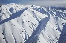
Mountain systems
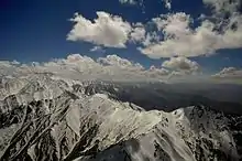
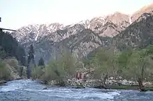
The Hindu Kush mountain range reaches a height of 7,492 m (24,580 ft) at Noshaq, Afghanistan's highest peak. Of the ranges extending southwestward from the Hindu Kush, the Foladi peak (Shah Foladi) of the Baba mountain range (Koh-i-Baba) reaches the greatest height: 5,142 m (16,870 ft). The Safed Koh range, which includes the Tora Bora area, dominates the border area southeast of Kabul.
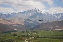
Important passes include the Unai Pass across the Safed Koh, the Kushan and Salang Passes through the Hindu Kush, and the Khyber Pass that connects Afghanistan with Pakistan. The summit of the Khyber Pass at 1,070 m (3,510 ft) at Landi Kotal, Pakistan is 5 km (3 mi) east of the border town of Torkham. Other key passages through the mountainous Pakistan border include two from Paktika Province into Pakistan's Waziristan region: one at Angoor Ada, and one further south at the Gumal River crossing, plus the Charkai River passage south of Khost, Afghanistan, at Pakistan's Ghulam Khan village into North Waziristan. The busy Pak-Afghan border crossing at Wesh, Afghanistan is in a flat and dry area, though this route involves Pakistan's Khojak Pass at 2,707 m (8,881 ft) just 14 km (9 mi) from the border. The border connects Kandahar and Spin Boldak in Afghanistan with Quetta in Pakistan,
The Wakhan Corridor in the northeast lies eastward of the province of Panjshir, between the Hindu Kush and the Pamir Mountains, which leads to the Wakhjir Pass into Xinjiang in China. In Kabul, and over all the northern part of the country to the descent at Gandamak, winter is rigorous, especially so on the high Arachosian plateau.

Although Herat is approximately 240 m (787 ft) lower than Kandahar, the summer climate there is more temperate along with the yearly climate. From May to September, the wind blows from the northwest with great force, and this extends across the country to Kandahar. The winter is mild; snow melts as it falls, and even on the mountains does not lie long. Three years out of four at Herat it does not freeze hard enough for the people to store ice. Yet, it was not very far from Herat, in Rafir Kala, in 1750, where Ahmad Shah's army, retreating from Persia, is said to have lost 18,000 men from cold in a single night. In the northern Herat districts records of the coldest month (February) show the mean minimum as −8 °C (18 °F) and the maximum as 3 °C (37 °F). The eastern reaches of the Hari River, including the rapids, are frozen hard in the winter, and people travel on it as on a road.
Rivers and lakes
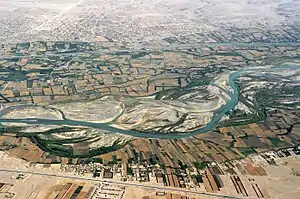
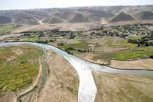
Afghanistan usually does not face much water shortage because it receives snow during winter and once that melts the water runs into numerous rivers, lakes, and streams, but most of its national water flows into neighboring countries. It loses about two-thirds of its water to neighboring Pakistan, Iran, Tajikistan, Uzbekistan and Turkmenistan.
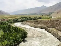
The nation's drainage system is essentially landlocked. Most of the rivers and streams end in shallow desert lakes or oases inside or outside the country's boundaries. Nearly half of the nation's total area is drained by watercourses south of the Hindu Kush–Safid ridge line, and half of this area is drained by the Helmand and its tributaries alone. The Amu Darya on the northern border, the country's other major river, has the next largest drainage area.
The 2,661 km (1,653 mi) long Amu Darya originates in the glaciers of the Pamir Mountains in the northeast. Some 965 km of its upper course constitutes Afghanistan's border with Turkmenistan, Uzbekistan and Tajikistan. Flowing in rapid torrents in its upper course, the Amu Darya becomes calmer below the mouth of the Kokcha, 96 km (60 mi) west of Fayzabad. The Kunduz River is another major tributary. During its flood period the upper course of the Amu Darya, swollen by snow and melting ice, carries along much gravel and large boulders.
The Helmand River is the principal river in the southwest, bisecting the entire region. Starting some 80 km (50 mi) west of Kabul in the Baba mountain range, the Helmand is approximately 1,400 km (870 mi) long, making it the longest river situated entirely within Afghanistan. With its many tributaries, the most important of which is the Arghandab River, it drains more than 298 km2 (115 sq mi).
The Kabul River, 515 km (320 mi) long, is a vital source of water in the Baba Mountains and for Kabul itself, which it flows through. The Kabul and its tributaries are among the few in Afghanistan that eventually reach the sea, as it flows east into the Indus River in Pakistan.
In the west the sandy deserts along most of the Iranian frontier have no watercourses. However, in the northwest, the Hari and Morghab Rivers flow into Turkmenistan's Karakum Desert.
Vegetation
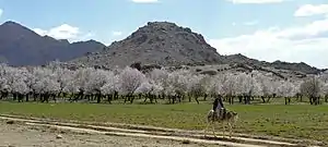
The characteristic distribution of vegetation on the mountains of Afghanistan is worthy of attention. The great mass of it is confined to the main ranges and their immediate offshoots, whilst on the more distant and terminal prolongations it is almost entirely absent; in fact, these are naked rock and stone. On the Safed Koh alpine range itself and its immediate branches, at a height of 1,800–3,000 m (5,900–9,800 ft) there is abundant growth of large forest trees, among which conifers are the most noble and prominent, such as Cedrus deodara, Abies excelsa, Pinus longifolia, Pinus pinaster, Stone pine (the edible pine, although this species is probably introduced, since it is original to Spain and Portugal) and the larch. There is also the yew, the hazel, juniper, walnut, wild peach and almond. Growing under the shade of these are several varieties of rose, honeysuckle, currant, gooseberry, hawthorn, rhododendron and a luxuriant herbage, among which the ranunculus family is important for frequency and number of genera. The lemon and wild vine are also here met with, but are more common on the northern mountains. The walnut and oak (evergreen, holly-leaved and kermes) descend to the secondary heights, where they become mixed with alder, ash, khinjak, Arbor-vitae, juniper, with species of Astragalus. Here also are Indigoferae rind dwarf laburnum.
Down to 1,000 m (3,300 ft) there are wild olive, species of rock-rose, wild privet, acacias and mimosas, barberry and Zizyphus; and in the eastern ramifications of the chain, Nannerops ritchiana (which is applied to a variety of useful purposes), Bignonia or trumpet flower, sissu, Salvadora persica, verbena, acanthus, varieties of Gesnerae.
The lowest terminal ridges, especially towards the west, are, as it has been said, naked in aspect. Their scanty vegetation is almost wholly herbal; shrubs are only occasional; trees almost non-existent. Labiate, composite and umbelliferous plants are most common. Ferns and mosses are almost confined to the higher ranges.
In the low brushwood scattered over portions of the dreary plains of the Kandahar tablelands, it is possible to find leguminous thorny plants of the papilionaceous suborder, such as camel-thorn (Hedysarum alhagi), Astragalus in several varieties, spiny rest-harrow (Ononis spinosa), the fibrous roots of which often serve as a tooth-brush; plants of the sub-order Mimosae, as the sensitive mimosa; a plant of the rue family, called by the natives lipad; the common wormwood; also certain orchids, and several species of Salsola. The rue and wormwood are in general use as domestic medicines—the former for rheumatism and neuralgia; the latter in fever, debility and dyspepsia, as well as for a vermifuge. The lipad, owing to its heavy nauseous odour, is believed to keep off evil spirits. In some places, occupying the sides and hollows of ravines, it is found the Rose Bay, called in Persian khar-zarah, or ass-bane, the wild laburnum and various Indigoferae.
In the last several decades, 90% of forests in Afghanistan have been destroyed and much of the timber has been exported to neighboring Pakistan. As a result, large percent of Afghanistan's land could be subject to soil erosion and desertification. On the positive note, the Karzai administration and international organizations are helping counter this problem by often planting millions of saplings.[10] Afghanistan had a 2018 Forest Landscape Integrity Index mean score of 8.85/10, ranking it 15th globally out of 172 countries.[11]
References
- Afghanistan , CIA World Factbook.
- "Gold and copper discovered in Afghanistan" (PDF). bgs.ac.uk. Archived (PDF) from the original on 26 July 2013. Retrieved 5 May 2018.
- "Uranium Mining Issues: 2005 Review". www.wise-uranium.org. Retrieved 5 May 2018.
- Afghanistan's Energy Future and its Potential Implications Archived 2010-06-25 at the Wayback Machine, Eurasianet.org.
- Govt plans to lease out Ainak copper mine, Pajhwok Afghan News.
- "Composition of macro geographical (continental) regions, geographical sub-regions, and selected economic and other groupings". UNdata. 26 April 2011. Archived from the original on 13 July 2011. Retrieved 13 July 2011.
- "20th-century international relations". Britannica.com. 8 December 1987. Archived from the original on 14 January 2006. Retrieved 21 June 2013.
- "Country Profile: Afghanistan" (PDF). United States: Library of Congress Country Studies on Afghanistan. August 2008. Archived from the original (PDF) on April 8, 2014. Retrieved February 11, 2012.
- "Archived copy" (PDF). Archived (PDF) from the original on 2016-10-06. Retrieved 2017-12-19.CS1 maint: archived copy as title (link)
- "Citizens Plant 1.2 Million Trees in Eastern Afghanistan". USAID Afghanistan. April 15, 2009. Archived from the original on March 7, 2013. Retrieved March 31, 2012.
- Grantham, H. S.; Duncan, A.; Evans, T. D.; Jones, K. R.; Beyer, H. L.; Schuster, R.; Walston, J.; Ray, J. C.; Robinson, J. G.; Callow, M.; Clements, T.; Costa, H. M.; DeGemmis, A.; Elsen, P. R.; Ervin, J.; Franco, P.; Goldman, E.; Goetz, S.; Hansen, A.; Hofsvang, E.; Jantz, P.; Jupiter, S.; Kang, A.; Langhammer, P.; Laurance, W. F.; Lieberman, S.; Linkie, M.; Malhi, Y.; Maxwell, S.; Mendez, M.; Mittermeier, R.; Murray, N. J.; Possingham, H.; Radachowsky, J.; Saatchi, S.; Samper, C.; Silverman, J.; Shapiro, A.; Strassburg, B.; Stevens, T.; Stokes, E.; Taylor, R.; Tear, T.; Tizard, R.; Venter, O.; Visconti, P.; Wang, S.; Watson, J. E. M. (2020). "Anthropogenic modification of forests means only 40% of remaining forests have high ecosystem integrity - Supplementary Material". Nature Communications. 11 (1). doi:10.1038/s41467-020-19493-3. ISSN 2041-1723.
Further reading
- 1911 Encyclopædia Britannica– physical geography
- Federal Research Division, Library of Congress. 1997. "Afghanistan: A Country Sturdy".
External links
| Wikimedia Commons has media related to Geography of Afghanistan. |
- Topographic map of Afghanistan (1 : 300 000)
- Persia (Iran), Afghanistan and Baluchistan is a map from 1897
- Afghanistan, Beloochistan, etc. is a map from 1893 created by the American Methodist Church
| Sovereign states |
|
|---|---|
| States with limited recognition |
|
| Dependencies and other territories |
|
| |