Minnesota State Highway 25
Minnesota State Highway 25 (MN 25) is a 156.066-mile-long (251.164 km) highway in Minnesota, which runs from its interchange with U.S. Highway 169 in Belle Plaine and continues north to its intersection with State Highway 210 in Brainerd.
| ||||
|---|---|---|---|---|
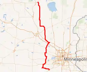
MN 25 highlighted in red | ||||
| Route information | ||||
| Maintained by MnDOT | ||||
| Length | 156.066 mi[1] (251.164 km) | |||
| Existed | November 2, 1920[2]–present | |||
| Major junctions | ||||
| South end | ||||
| ||||
| North end | ||||
| Location | ||||
| Counties | Scott, Sibley, Carver, Wright, Sherburne, Benton, Morrison, Crow Wing | |||
| Highway system | ||||
| ||||

Route description
State Highway 25 serves as a north–south route in central Minnesota between Belle Plaine, Norwood Young America, Watertown, Buffalo, Monticello, Big Lake, Becker, Foley, and Brainerd.
The route travels east–west between Belle Plaine and Green Isle for 15 miles.
Highway 25 crosses the Minnesota River at Belle Plaine.
The route crosses the Highway 25 Bridge at the Mississippi River between Monticello and Big Lake.
History
State Highway 25 was authorized November 2, 1920 from Belle Plaine to Big Lake.[2]
The roadway was fully graveled by 1928.[3] It was paved in stages from north to south throughout the 1930s: from Big Lake to Buffalo in 1931,[4] Buffalo to Montrose in 1932,[5] Montrose to Watertown in 1933,[6][7] and Watertown to Norwood in 1934.[7][8]
Paving was completed in Belle Plaine in 1937,[9] and the remaining gravel section through Sibley County was paved in 1950.[10]
When the four-lane bypass of U.S. 169 around Belle Plaine was built in 1955, Highway 25 was extended east along 169's former alignment to intersect the new highway.[9]
In 1961, Highway 25 was extended north along what had previously been State Highway 218 from Becker to Merrifield. This highway was already paved in its entirety.[11][12]
In 2001, the northernmost segment of the highway between State Highway 210 and Merrifield was turned back to Crow Wing County maintenance[13] and is now designated County Road 3.[14]
Major intersections
| County | Location | mi[1] | km | Destinations | Notes |
|---|---|---|---|---|---|
| Scott | Belle Plaine | 0.000 | 0.000 | Interchange | |
| Minnesota River | 2.008– 2.120 | 3.232– 3.412 | Highway 25 Bridge | ||
| Sibley | Green Isle | 25.884 | 41.656 | South end of MN 5 overlap | |
| Carver | Young America Township | 22.540 | 36.275 | West end of US 212 overlap | |
| Norwood Young America | 24.874 | 40.031 | East end of US 212 overlap | ||
| Young America Township | 62.998 | 101.385 | North end of MN 5 overlap | ||
| Watertown Township | 35.305– 35.335 | 56.818– 56.866 | Roundabout | ||
| Wright | Montrose | 48.383 | 77.865 | West end of US 12 overlap | |
| Rockford Township | 50.481 | 81.241 | East end of US 12 overlap | ||
| Buffalo | 58.724 | 94.507 | |||
| Monticello | 68.040 | 109.500 | I-94 exit 193; interchange. | ||
| Mississippi River | 68.722– 68.912 | 110.597– 110.903 | Highway 25 Bridge | ||
| Sherburne | Big Lake | 71.753 | 115.475 | East end of US 10 overlap | |
| Becker | 81.241 | 130.745 | West end of US 10 overlap | ||
| Benton | St. George Township | 93.873 | 151.074 | ||
| Gilmanton Township | 99.312 | 159.827 | |||
| Morrison | Genola | 128.230 | 206.366 | South end of MN 27 overlap | |
| Buh Township | 132.351 | 212.998 | North end of MN 27 overlap | ||
| Crow Wing | Brainerd | 155.751 | 250.657 | ||
| 157.069 | 252.778 | ||||
1.000 mi = 1.609 km; 1.000 km = 0.621 mi
| |||||
References
- "Statewide Trunk Logpoint Listing" (PDF). Minnesota Department of Transportation. Archived from the original (PDF) on 2012-09-14. Retrieved 9 February 2021.
- Minnesota State Legislature (2010). "§ 161.114, Constitutional Trunk Highways". Minnesota Statutes. Minnesota Office of the Revisor of Statutes. Retrieved October 12, 2010.
- 1928 Map of Trunk Highway System, State of Minnesota (Map). Cartography by McGill-Warner Co. Minnesota Highway Department. May 1, 1928. § J-19 through K-17. Retrieved January 26, 2019.
- "Construction Project Log Record: Control Section 8605" (PDF). Minnesota Department of Transportation. Retrieved January 26, 2019.
- "Construction Project Log Record: Control Section 8604" (PDF). Minnesota Department of Transportation. Retrieved January 26, 2019.
- "Construction Project Log Record: Control Section 8603" (PDF). Minnesota Department of Transportation. Retrieved January 26, 2019.
- "Construction Project Log Record: Control Section 1007" (PDF). Minnesota Department of Transportation. Retrieved January 26, 2019.
- "Construction Project Log Record: Control Section 1006" (PDF). Minnesota Department of Transportation. Retrieved January 26, 2019.
- "Construction Project Log Record: Control Section 7003" (PDF). Minnesota Department of Transportation. Retrieved January 26, 2019.
- "Construction Project Log Record: Control Section 7209" (PDF). Minnesota Department of Transportation. Retrieved January 26, 2019.
- 1961 Official Road Map, Minnesota (Map). Cartography by The H.M. Gousha Co. Minnesota Department of Highways. 1961. § H-11 through H-14. Retrieved January 26, 2019.
- 1962 Official Road Map - Minnesota (Map). Minnesota Department of Highways. 1962. § H-11 through H-14. Retrieved January 26, 2019.
- "Chapter 213, S.F. No. 1769, Sec. 29". Office of the Revisor of Statutes, State of Minnesota. May 29, 2001. Retrieved October 12, 2010.
- General Highway Map - Crow Wing County, Minnesota (PDF) (Map). Minnesota Department of Transportation. 2010. Archived from the original (PDF) on November 11, 2011. Retrieved October 12, 2010.