Wright County, Minnesota
Wright County is a county in the East Central part of the U.S. state of Minnesota. As of the 2010 United States Census, the population was 124,700.[2] Its county seat is Buffalo.[3] The county was founded in 1855. Wright County is part of the Minneapolis-St. Paul-Bloomington, MN-WI Metropolitan Statistical Area. In terms of population, Wright County is the tenth-largest county in Minnesota and the second-fastest growing.
Wright County | |
|---|---|
 | |
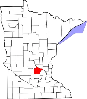 Location within the U.S. state of Minnesota | |
 Minnesota's location within the U.S. | |
| Coordinates: 45°11′N 93°58′W | |
| Country | |
| State | |
| Founded | February 20, 1855[1] |
| Named for | Silas Wright |
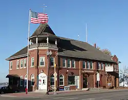
| Seat | Buffalo |
| Largest city | St. Michael |
| Area | |
| • Total | 714 sq mi (1,850 km2) |
| • Land | 661 sq mi (1,710 km2) |
| • Water | 53 sq mi (140 km2) 7.4%% |
| Population (2010) | |
| • Total | 124,700 |
| • Estimate (2020) | 140,852 |
| • Density | 206/sq mi (80/km2) |
| Time zone | UTC−6 (Central) |
| • Summer (DST) | UTC−5 (CDT) |
| Congressional district | 6th |
| Website | www |
History
The county was established in 1855, and was named for New York politician Silas Wright.[4] The first county seat was Monticello; in 1868 the county seat was changed to Buffalo. Most of the area's first settlers were of German and Swedish origin. The county's population in 1860 was 3,729; in 1875, it was 13,775.[5]
The 1998 thriller A Simple Plan was set in Wright County, though it does not mention a specific town.
Geography
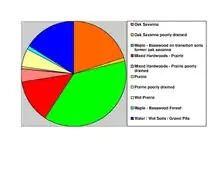
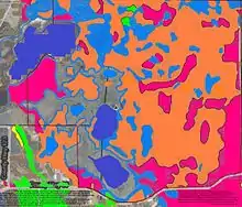
According to the United States Census Bureau, the county has an area of 714 square miles (1,850 km2), of which 661 square miles (1,710 km2) is land and 53 square miles (140 km2) (7.4%) is water.[7] The terrain is undulating and contains numerous small lakes. The county is bounded on the northeast by the Mississippi River.[5] Wright is one of 17 Minnesota savanna region counties with more savanna soils than either prairie or forest soils, and one of only two Minnesota counties where savanna soils make up more than 75% of the county area (the other is Hennepin County).
Major highways
Adjacent counties
- Sherburne County - northeast
- Hennepin County - east
- Carver County - southeast
- McLeod County - southwest
- Meeker County - west
- Stearns County - northwest
- Anoka County - northeast
Demographics
| Historical population | |||
|---|---|---|---|
| Census | Pop. | %± | |
| 1860 | 3,729 | — | |
| 1870 | 9,457 | 153.6% | |
| 1880 | 18,104 | 91.4% | |
| 1890 | 24,164 | 33.5% | |
| 1900 | 29,157 | 20.7% | |
| 1910 | 28,082 | −3.7% | |
| 1920 | 28,685 | 2.1% | |
| 1930 | 27,119 | −5.5% | |
| 1940 | 27,550 | 1.6% | |
| 1950 | 27,716 | 0.6% | |
| 1960 | 29,935 | 8.0% | |
| 1970 | 38,933 | 30.1% | |
| 1980 | 58,681 | 50.7% | |
| 1990 | 68,710 | 17.1% | |
| 2000 | 89,986 | 31.0% | |
| 2010 | 124,700 | 38.6% | |
| 2020 (est.) | 140,852 | [8] | 13.0% |
| US Decennial Census[9] 1790–1960[10] 1900–1990[11] 1990–2000[12] 2010–2019[2] | |||
2010
The ethnic makeup of the county, according to the 2010 United States Census, was the following:
- 95.04% White
- 1.06% Black
- 0.34% Native American
- 1.19% Asian
- 0.04% Native Hawaiian or Pacific Islander
- 1.53% Two or more races
- 0.81% Other races
- 2.45% Hispanic or Latino (of any race)
2000
As of the 2000 census, there were 89,986 people, 31,465 households, and 23,913 families in the county. The population density was 136 people per square mile (53/km2). There were 34,355 housing units at an average density of 52 per square mile (20/km2). The racial makeup of the county was 97.85% White, 0.26% Black or African American, 0.28% Native American, 0.44% Asian, 0.01% Pacific Islander, 0.36% from other races, and 0.80% from two or more races. 1.10% of the population were Hispanic or Latino of any race. 42.3% were of German, 11.9% Norwegian, 7.4% Swedish and 6.6% Irish ancestry.
There were 31465 households, out of which 42.10% had children under the age of 18 living with them, 64.50% were married couples living together, 7.70% had a female householder with no husband present, and 24.00% were non-families. 18.80% of all households were made up of individuals, and 6.80% had someone living alone who was 65 years of age or older. The average household size was 2.83 and the average family size was 3.26.
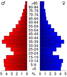
The county population contained 31.10% under the age of 18, 7.60% from 18 to 24, 32.60% from 25 to 44, 19.90% from 45 to 64, and 8.80% over age 64. The median age was 33 years. For every 100 females there were 101.40 males. For every 100 females age 18 and over, there were 99.90 males.
The median income for a household in the county was $53,945, and the median income for a family was $60,940. Males had a median income of $40,630 versus $28,201 for females. The per capita income for the county was $21,844. About 3.60% of families and 4.70% of the population were below the poverty line, including 5.50% of those under age 18 and 7.40% of those age 65 or over.
Government and politics
| Year | Republican | Democratic | Third parties |
|---|---|---|---|
| 2020 | 63.1% 51,973 | 34.5% 28,430 | 2.5% 2,023 |
| 2016 | 62.2% 43,274 | 29.2% 20,334 | 8.6% 6,010 |
| 2012 | 59.7% 40,466 | 38.0% 25,741 | 2.4% 1,609 |
| 2008 | 57.6% 37,779 | 40.2% 26,343 | 2.2% 1,456 |
| 2004 | 60.8% 36,176 | 38.0% 22,618 | 1.2% 740 |
| 2000 | 55.0% 23,861 | 38.7% 16,762 | 6.3% 2,743 |
| 1996 | 37.9% 13,224 | 44.6% 15,542 | 17.5% 6,108 |
| 1992 | 33.1% 11,650 | 35.5% 12,465 | 31.4% 11,045 |
| 1988 | 50.7% 14,987 | 48.0% 14,177 | 1.3% 379 |
| 1984 | 54.8% 15,399 | 44.5% 12,486 | 0.7% 205 |
| 1980 | 45.5% 12,293 | 45.9% 12,383 | 8.6% 2,315 |
| 1976 | 39.7% 9,314 | 57.0% 13,379 | 3.3% 771 |
| 1972 | 51.6% 9,996 | 44.9% 8,695 | 3.6% 695 |
| 1968 | 40.1% 6,321 | 55.8% 8,793 | 4.1% 639 |
| 1964 | 38.6% 5,476 | 61.2% 8,687 | 0.2% 22 |
| 1960 | 52.6% 7,180 | 47.2% 6,452 | 0.2% 26 |
| 1956 | 59.4% 7,257 | 40.5% 4,944 | 0.1% 12 |
| 1952 | 64.6% 8,089 | 34.9% 4,373 | 0.5% 62 |
| 1948 | 49.5% 5,589 | 48.9% 5,523 | 1.6% 185 |
| 1944 | 65.0% 6,961 | 34.3% 3,678 | 0.7% 72 |
| 1940 | 67.0% 8,297 | 32.3% 3,993 | 0.7% 87 |
| 1936 | 36.0% 4,087 | 47.3% 5,363 | 16.8% 1,901 |
| 1932 | 31.5% 3,406 | 66.5% 7,205 | 2.0% 219 |
| 1928 | 56.6% 6,011 | 42.2% 4,483 | 1.2% 132 |
| 1924 | 47.5% 4,349 | 6.2% 567 | 46.3% 4,235 |
| 1920 | 79.5% 7,013 | 14.7% 1,299 | 5.8% 508 |
| 1916 | 52.2% 2,683 | 44.0% 2,262 | 3.7% 191 |
| 1912 | 19.4% 837 | 30.9% 1,333 | 49.6% 2,139 |
| 1908 | 63.5% 2,820 | 31.4% 1,396 | 5.1% 226 |
| 1904 | 75.0% 3,183 | 20.3% 860 | 4.7% 199 |
| 1900 | 60.7% 3,153 | 36.4% 1,888 | 2.9% 152 |
| 1896 | 59.4% 3,312 | 38.9% 2,172 | 1.7% 95 |
| 1892 | 48.6% 2,271 | 39.1% 1,829 | 12.3% 577 |
| Position | Name | District | Next Election |
|---|---|---|---|
| Commissioner | Christine Husom | District 1 | 2022 |
| Commissioner | Darek Vetsch | District 2 | 2020 |
| Commissioner | Mark Daleiden | District 3 | 2022 |
| Commissioner | Michael Potter | District 4 | 2020 |
| Commissioner | Charles Borrell | District 5 | 2020 |
| Position | Name | Affiliation | District | |
|---|---|---|---|---|
| Senate | Andrew Mathews [15] | Republican | District 15 | |
| Senate | Scott Newman[16] | Republican | District 18 | |
| Senate | Bruce Anderson[17] | Republican | District 29 | |
| Senate | Mary Kiffmeyer[18] | Republican | District 30 | |
| House of Representatives | Shane Mekeland[19] | Republican | District 15B | |
| House of Representatives | Dean Erdahl[20] | Republican | District 18A | |
| House of Representatives | Joe McDonald[21] | Republican | District 29A | |
| House of Representatives | Marion O'Neill[22] | Republican | District 29B | |
| House of Representatives | Eric Lucero[23] | Republican | District 30B | |
| Position | Name | Affiliation | District | |
|---|---|---|---|---|
| House of Representatives | Tom Emmer[24] | Republican | 6th | |
| Senate | Amy Klobuchar[25] | Democrat | N/A | |
| Senate | Tina Smith[26] | Democrat | N/A | |
Communities
Cities
Townships
Census-designated place
Other unincorporated communities
Ghost town
Largest Cities in Wright County
| 2019 Rank | City | 2010 Census | 2019 Estimate[27] | Percent Increase |
|---|---|---|---|---|
| 1 | St. Michael | 16,399 | 18,204 | +11.01% |
| 2 | Otsego | 13,571 | 18,113 | +33.47% |
| 3 | Buffalo | 15,453 | 16,442 | +6.40% |
| 4 | Monticello | 12,759 | 13,824 | +8.35% |
| 5 | Albertville | 7,044 | 7,539 | +7.03% |
| 6 | Delano | 5,464 | 6,302 | +15.34% |
| 7 | Rockford | 4,316 | 4,515 | +4.61% |
| 8 | Annandale | 3,228 | 3,517 | +8.95% |
| 9 | Hanover | 2,938 | 3,507 | +19.37% |
| 10 | Montrose | 2,847 | 3,317 | +16.51% |
| 11 | Cokato | 2,694 | 2,747 | +1.97% |
References
- "Minnesota Place Names". Minnesota Historical Society. Retrieved March 19, 2014.
- "State & County QuickFacts". US Census Bureau. Retrieved September 1, 2013.
- "Find a County". National Association of Counties. Retrieved June 7, 2011.
- Upham, Warren (1920). Minnesota Geographic Names: Their Origin and Historic Significance. Minnesota Historical Society. p. 586.
- Ripley, George; Dana, Charles A., eds. (1879). . The American Cyclopædia.
- Nelson, Steven (2011). Savanna Soils of Minnesota. Minnesota: Self. pp. 49–52. ISBN 978-0-615-50320-2.
- "2010 Census Gazetteer Files". US Census Bureau. August 22, 2012. Archived from the original on October 6, 2014. Retrieved October 25, 2014.
- "Population and Housing Unit Estimates". Retrieved May 21, 2020.}
- "US Decennial Census". US Census Bureau. Retrieved October 25, 2014.
- "Historical Census Browser". University of Virginia Library. Retrieved October 25, 2014.
- "Population of Counties by Decennial Census: 1900 to 1990". US Census Bureau. Retrieved October 25, 2014.
- "Census 2000 PHC-T-4. Ranking Tables for Counties: 1990 and 2000" (PDF). US Census Bureau. Retrieved October 25, 2014.
- Leip, David. "Atlas of US Presidential Elections". uselectionatlas.org.
- "Board of Commissioners | Wright County, MN - Official Website". www.co.wright.mn.us. Retrieved 2020-06-26.
- "MN State Senate". www.senate.mn. Retrieved 2020-06-25.
- "MN State Senate". www.senate.mn. Retrieved 2020-06-26.
- "MN State Senate". www.senate.mn. Retrieved 2020-06-26.
- "MN State Senate". www.senate.mn. Retrieved 2020-06-26.
- "Rep. Shane Mekeland (15B) - Minnesota House of Representatives". www.house.leg.state.mn.us. Retrieved 2020-06-25.
- "Rep. Dean Urdahl (18A) - Minnesota House of Representatives". www.house.leg.state.mn.us. Retrieved 2020-06-26.
- "Rep. Joe McDonald (29A) - Minnesota House of Representatives". www.house.leg.state.mn.us. Retrieved 2020-06-26.
- "Rep. Marion O'Neill (29B) - Minnesota House of Representatives". www.house.leg.state.mn.us. Retrieved 2020-06-26.
- "Rep. Eric Lucero (30B) - Minnesota House of Representatives". www.house.leg.state.mn.us. Retrieved 2020-06-26.
- "Congressman Tom Emmer". Congressman Tom Emmer. Retrieved 2020-06-25.
- "U.S. Senator Amy Klobuchar". www.klobuchar.senate.gov. Retrieved 2020-06-24.
- "Home". Senator Tina Smith. Retrieved 2020-06-24.
- "City and Town Population Totals: 2010-2019". U.S. Census Bureau. Retrieved June 13, 2019.
External links
Places adjacent to Wright County, Minnesota | ||||||||||
|---|---|---|---|---|---|---|---|---|---|---|
| ||||||||||
Municipalities and communities of Wright County, Minnesota, United States | ||
|---|---|---|
| Cities | Map of Minnesota highlighting Wright County | |
| Townships | ||
| CDP | ||
| Unincorporated communities | ||
| Ghost town | ||
| Footnotes | ‡This populated place also has portions in an adjacent county or counties | |
| ||

| Authority control |
|---|