Koochiching County, Minnesota
Koochiching County (/ˈkuːtʃɪtʃɪŋ/ KOO-chitch-ing) is a county in the U.S. state of Minnesota. As of the 2010 census, the population was 13,311.[2] Its county seat is International Falls.[3] A portion of the Bois Forte Indian Reservation is in the county. A small part of Voyageurs National Park extends into its boundary, with Lake of the Woods County to its northwest.
Koochiching County | |
|---|---|
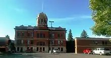 International Falls landmark. | |
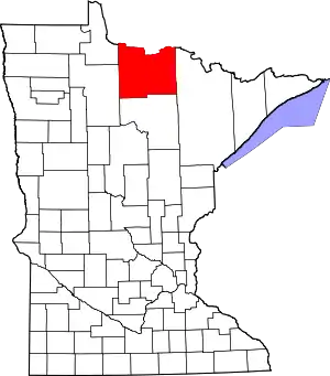 Location within the U.S. state of Minnesota | |
 Minnesota's location within the U.S. | |
| Coordinates: 48°16′N 93°46′W | |
| Country | |
| State | |
| Founded | December 19, 1906[1] |
| Named for | Ojibway words for neighbor lake, river |
| Seat | International Falls |
| Largest city | International Falls |
| Area | |
| • Total | 3,154 sq mi (8,170 km2) |
| • Land | 3,104 sq mi (8,040 km2) |
| • Water | 50 sq mi (100 km2) 1.6%% |
| Population (2010) | |
| • Total | 13,311 |
| • Estimate (2019) | 12,229 |
| • Density | 4.04/sq mi (1.56/km2) |
| Time zone | UTC−6 (Central) |
| • Summer (DST) | UTC−5 (CDT) |
| Congressional district | 8th |
| Website | www |
History
About 10,000 years ago almost 90% of Koochiching County was covered by Lake Agassiz. When it receded it left low areas of decayed vegetation (muskeg); as a result, three-quarters of northern Koochiching are underlain with 2 to 50 feet of peat.[4][5]
The name "Koochiching" comes from either the Ojibwe word Gojijiing or Cree Kocicīhk (recorded in some documents as "Ouchichiq"), both meaning "at the place of inlets," referring to the neighboring Rainy Lake and River. Reverend J.A. Gilfillan recorded their meaning, "according to some, Neighbor lake, according to others a lake somewhere," possibly referring to the neighbouring Rainy Lake and to Lake Couchiching located in southern Ontario. Early European (French) inhabitants gave the names Lac à la Pluie (Rainy Lake) and Rivière à la Pluie (Rainy River) to the nearby bodies of water because of the mist-like rain present at the falls of Rainy River and then to the settlement that became known as International Falls.
European settlers in Koochiching County were of many occupations. They were explorers, traders, homesteaders, and lumberjacks. They also were teachers, preachers, merchants, engineers, and builders of industry. Settlers came at the beginning of the 1900s and suffered through isolation, illness, harsh weather, and poverty. They built schools, churches, and good roads.
Koochiching County is the second largest county in area next to Saint Louis County. It is also one of the youngest counties in the state having been created in 1906 after it was separated from Itasca County.
Geography
Koochiching County lies on the northern edge of Minnesota. Its northern border abuts the south border of Canada (across the Rainy River). The Rainy River flows west-northwestward along its north border, being fed by several rivers which drain from the county into the Rainy: Rat Root River drains the east central part of the county; Little Fork River flows northward through the eastern part of the county; Big Fork River flows northward through the east-central part of the county; Black River flows northward through the central part of the county; Rapid River and East Fork Rapid River flow north-northwestward through the western part of the county, joining in the northwestern part of the county shortly before exiting the county's west line to discharge into the Rainy, just west of the county's northwestern corner.
The county terrain consists of low rolling hills, with swampy areas where Lake Agassiz basin was deepest. There are also deposits of peat from 1½ to 50 feet in the low areas. The fairly level soil is broken by ledges of precambrian rock. Bed rock in the area includes Ely greenstone and greenstone schists that are said to be among the oldest on the planet.[6] The terrain slopes to the north, with its highest point on the western part of its southern border at 1,515' (462m) ASL.[7] The county has a total area of 3,154 square miles (8,170 km2), of which 3,104 square miles (8,040 km2) is land and 50 square miles (130 km2) (1.6%) is water.[8] It is the second-largest county in Minnesota by land area and third-largest by total area.
Major highways
Adjacent counties
- Rainy River District, Ontario - north
- Saint Louis County - east
- Itasca County - south
- Beltrami County - southwest
- Lake of the Woods County - northwest
Protected areas[6]
- East Rat Root River Scientific and Natural Area
- Lost River Peatland Scientific and Natural Area
- Myrtle Lake Peatland Scientific and Natural Area
- Pine Island State Forest
- Smoky Bear State Forest
- South Black River Peatland Scientific and Natural Area
- Superior National Forest (part)
- Voyageurs National Park (part)
Lakes[6]
- Bartlett Lake
- Battle Lake
- Cameron Lake
- Clear Lake
- Dark Lake
- Franklin Lake
- Larson Lake
- Little Constance Lake
- Little Lake
- Lost Lake
- Moose Lake
- Myrtle Lake
- Nett Lake (part)
- Pine Lake
- Pocquette Lake
- Rainy Lake (part)
- Rat Root Lake
- Seretha Lake
- Silversack Lake
- Teufer Lake
Demographics
| Historical population | |||
|---|---|---|---|
| Census | Pop. | %± | |
| 1910 | 6,431 | — | |
| 1920 | 13,520 | 110.2% | |
| 1930 | 14,078 | 4.1% | |
| 1940 | 16,930 | 20.3% | |
| 1950 | 16,910 | −0.1% | |
| 1960 | 18,190 | 7.6% | |
| 1970 | 17,131 | −5.8% | |
| 1980 | 17,571 | 2.6% | |
| 1990 | 16,299 | −7.2% | |
| 2000 | 14,355 | −11.9% | |
| 2010 | 13,311 | −7.3% | |
| 2019 (est.) | 12,229 | [9] | −8.1% |
| US Decennial Census[10] 1790-1960[11] 1900-1990[12] 1990-2000[13] 2010-2019[2] | |||
2000 census
As of the 2000 United States Census, there were 14,355 people, 6,040 households, and 3,962 families in the county. The population density was 4.62/sqmi (1.79/km2). There were 7,719 housing units at an average density of 2.49/sqmi (0.96/km2). The racial makeup of the county was 96.12% White, 0.19% Black or African American, 2.15% Native American, 0.17% Asian, 0.06% Pacific Islander, 0.08% from other races, and 1.23% from two or more races. 0.56% of the population were Hispanic or Latino of any race. 21.2% were of Norwegian, 19.8% German, 12.3% Swedish and 7.0% Irish ancestry.
There were 6,040 households, out of which 28.40% had children under the age of 18 living with them, 53.30% were married couples living together, 8.50% had a female householder with no husband present, and 34.40% were non-families. 30.40% of all households were made up of individuals, and 14.50% had someone living alone who was 65 years of age or older. The average household size was 2.33 and the average family size was 2.88.
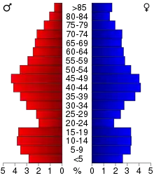
The county population contained 23.90% under the age of 18, 6.40% from 18 to 24, 25.80% from 25 to 44, 26.00% from 45 to 64, and 18.00% who were 65 years of age or older. The median age was 42 years. For every 100 females there were 98.50 males. For every 100 females age 18 and over, there were 95.20 males.
The median income for a household in the county was $36,262, and the median income for a family was $43,608. Males had a median income of $40,642 versus $22,261 for females. The per capita income for the county was $19,167. About 8.40% of families and 12.10% of the population were below the poverty line, including 16.10% of those under age 18 and 13.40% of those age 65 or over.
Government and Politics
From 1932 through 1996, Koochiching County voters tended Democratic, selecting the Democratic nominee in every election save Nixon's 1972 landslide. In 2000, George W. Bush became the first Republican to carry the county since 1972, despite narrowly losing the overall national popular vote. It returned to the Democratic column in the subsequent three elections, although none of the Democratic nominees in those three elections managed as high a vote share as Mondale in 1984 or Dukakis in 1988. In 2016, Donald Trump became the second Republican since 1972 to carry the county (despite, like Bush in 2000, narrowly losing the national popular vote), and carried it again in 2020, with an increased majority--the first time the county has ever voted Republican two elections in a row.
| Year | Republican | Democratic | Third parties |
|---|---|---|---|
| 2020 | 59.7% 4,131 | 38.4% 2,659 | 1.9% 132 |
| 2016 | 56.1% 3,569 | 36.2% 2,306 | 7.7% 488 |
| 2012 | 44.0% 2,841 | 53.4% 3,451 | 2.6% 166 |
| 2008 | 43.6% 2,962 | 53.7% 3,649 | 2.8% 191 |
| 2004 | 48.4% 3,539 | 50.1% 3,662 | 1.5% 108 |
| 2000 | 51.2% 3,523 | 42.2% 2,903 | 6.6% 453 |
| 1996 | 30.9% 2,080 | 51.6% 3,472 | 17.5% 1,178 |
| 1992 | 26.2% 1,954 | 46.5% 3,474 | 27.3% 2,037 |
| 1988 | 41.9% 2,842 | 57.0% 3,867 | 1.1% 71 |
| 1984 | 44.8% 3,466 | 54.7% 4,238 | 0.5% 38 |
| 1980 | 41.6% 3,433 | 50.7% 4,181 | 7.7% 636 |
| 1976 | 36.1% 2,893 | 60.5% 4,846 | 3.4% 268 |
| 1972 | 50.9% 3,681 | 47.0% 3,396 | 2.1% 153 |
| 1968 | 29.6% 2,104 | 66.0% 4,697 | 4.4% 315 |
| 1964 | 21.4% 1,602 | 78.5% 5,878 | 0.2% 11 |
| 1960 | 39.9% 3,055 | 59.8% 4,578 | 0.3% 23 |
| 1956 | 42.6% 2,757 | 57.1% 3,695 | 0.3% 16 |
| 1952 | 40.0% 2,742 | 59.5% 4,078 | 0.5% 31 |
| 1948 | 24.7% 1,718 | 71.3% 4,968 | 4.1% 282 |
| 1944 | 28.5% 1,607 | 70.6% 3,981 | 0.9% 51 |
| 1940 | 28.5% 2,095 | 71.0% 5,219 | 0.5% 39 |
| 1936 | 20.2% 1,316 | 77.8% 5,065 | 2.0% 132 |
| 1932 | 28.7% 1,427 | 63.3% 3,148 | 8.0% 399 |
| 1928 | 53.7% 2,599 | 43.6% 2,110 | 2.8% 134 |
| 1924 | 37.4% 1,536 | 5.4% 222 | 57.2% 2,347 |
| 1920 | 55.3% 1,786 | 26.6% 859 | 18.1% 585 |
| 1916 | 25.7% 474 | 59.0% 1,089 | 15.3% 283 |
| 1912 | 12.6% 239 | 33.7% 638 | 53.7% 1,015[15] |
| 1908 | 56.0% 826 | 28.5% 420 | 15.5% 229 |
| Position | Name | District | Next Election | |
|---|---|---|---|---|
| Commissioner | Wade Pavleck | District 1 | 2022 | |
| Commissioner and Chairperson | Kevin Adee | District 2 | 2022 | |
| Commissioner | Brian McBride | District 3 | 2020 | |
| Commissioner and Vice Chair | David Sloblom | District 4 | 2022 | |
| Commissioner | Wayne Skoe | District 5 | 2020 | |
| Position | Name | Affiliation | District | |
|---|---|---|---|---|
| Senate | Tom Bakk[17] | Democrat | District 3 | |
| House of Representatives | Rob Ecklund[18] | Democrat | District 3A | |
| Position | Name | Affiliation | District | |
|---|---|---|---|---|
| House of Representatives | Pete Stauber[19] | Republican | 8th | |
| Senate | Amy Klobuchar[20] | Democrat | N/A | |
| Senate | Tina Smith[21] | Democrat | N/A | |
Communities
Koochiching County is unique in Minnesota, in the sense that there are no organized civil township governments within the county, due to legislative action taken by the county to absorb existing township governments. Survey townships, as defined by the Public Land Survey System exist but are not organized. Six city governments have been created, and the rest of the county consists of unorganized territories and unincorporated communities.
Cities[6]
- Big Falls
- International Falls (county seat; named Koochiching until January 1, 1903)
- Littlefork
- Mizpah
- Northome
- Ranier
- South International Falls (part of International Falls since 1987)[22]
Unorganized territories
Census-designated place
- Nett Lake (part)
Other unincorporated communities[6]
In popular culture
Koochiching County is the location of the fictional town of Frostbite Falls, the home of the animated characters Rocky and Bullwinkle. Frostbite Falls was probably named in honor of International Falls, since International Falls is often referred to as the nation's icebox.[24]
See also
References
- "Minnesota Place Names". Minnesota Historical Society. Archived from the original on June 20, 2012. Retrieved March 18, 2014.
- "State & County QuickFacts". United States Census Bureau. Archived from the original on June 7, 2011. Retrieved September 1, 2013.
- "Find a County". National Association of Counties. Archived from the original on May 31, 2011. Retrieved June 7, 2011.
- Schwankl, Hermoine Gordon (1983). "History of Koochiching County". Koochiching County. Archived from the original on April 5, 2010. Retrieved August 7, 2010.
- Soper, E. K. (1919). "Peat Deposits of Minnesota". Bulletin of the Minnesota Geological Survey (16): 172.
- Koochiching County MN Google Maps (accessed 17 March 2019)
- ""Find an Altitude/Koochiching County MN" Google Maps (accessed March 17, 2019)". Archived from the original on May 21, 2019. Retrieved March 17, 2019.
- "2010 Census Gazetteer Files". US Census Bureau. August 22, 2012. Archived from the original on September 21, 2013. Retrieved October 18, 2014.
- "Population and Housing Unit Estimates". Retrieved March 26, 2020.
- "US Decennial Census". US Census Bureau. Archived from the original on April 26, 2015. Retrieved October 18, 2014.
- "Historical Census Browser". University of Virginia Library. Retrieved October 18, 2014.
- "Population of Counties by Decennial Census: 1900 to 1990". US Census Bureau. Retrieved October 18, 2014.
- "Census 2000 PHC-T-4. Ranking Tables for Counties: 1990 and 2000" (PDF). US Census Bureau. Retrieved October 18, 2014.
- Leip, David. "Atlas of US Presidential Elections". uselectionatlas.org. Retrieved September 19, 2018.
- The leading "other" candidate, Progressive Theodore Roosevelt, received 522 votes, while Socialist candidate Eugene Debs received 460 votes, Prohibition candidate Eugene Chafin received 16 votes, and Socialist Labor candidate Arthur Reimer received 17 votes.
- "County Commission | Koochiching County, MN". www.co.koochiching.mn.us. Retrieved June 25, 2020.
- "MN State Senate". www.senate.mn. Retrieved June 24, 2020.
- "Rep. Rob Ecklund (03A) - Minnesota House of Representatives". www.house.leg.state.mn.us. Retrieved June 24, 2020.
- "Representative Pete Stauber". Representative Pete Stauber. Retrieved June 24, 2020.
- "U.S. Senator Amy Klobuchar". www.klobuchar.senate.gov. Retrieved June 24, 2020.
- "Home". Senator Tina Smith. Retrieved June 24, 2020.
- History of International Falls (page 4). Accessed March 17, 2019
- Rainy Lake City - National Park Service (accessed 17 March 2019)
- History of International Falls (p. 5) Accessed March 17, 2019
External links
| Wikimedia Commons has media related to Koochiching County, Minnesota. |
- County website
- Minnesota Department of Transportation maps (Southwest, Southeast, Northwest, Northeast)
- Koochiching County Historical Museum (Int'l Falls)
Places adjacent to Koochiching County, Minnesota | ||||||||||
|---|---|---|---|---|---|---|---|---|---|---|
| ||||||||||
Municipalities and communities of Koochiching County, Minnesota, United States | ||
|---|---|---|
| Cities | Map of Minnesota highlighting Koochiching County | |
| Unorganized territories | ||
| Unincorporated communities | ||
| Indian reservations | ||
| Ghost towns | ||
| Footnotes | ‡This populated place also has portions in an adjacent county or counties | |
| ||

| Authority control |
|---|