Mount Andromache
Mount Andromache is a 3,033-metre (9,951-foot) mountain summit located in the Bow River valley of Banff National Park, in the Canadian Rockies of Alberta, Canada. Its nearest higher peak is Mount Hector, 4.00 km (2.49 mi) to the south.[1] Mount Andromache can be seen from the Icefields Parkway as the road traverses the western base of the peak. The Molar Glacier is situated on the northeast aspect of the mountain.
| Mount Andromache | |
|---|---|
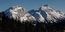 Mt. Andromache (left) and Mt. Hector (right) | |
| Highest point | |
| Elevation | 3,033 m (9,951 ft) [1] |
| Prominence | 518 m (1,699 ft) [1] |
| Parent peak | Mount Hector (3394 m) |
| Listing | Mountains of Alberta |
| Coordinates | 51°36′43″N 116°16′27″W [1] |
| Geography | |
 Mount Andromache Location of Mount Andromache in Alberta  Mount Andromache Mount Andromache (Canada) | |
| Location | Alberta, Canada |
| Parent range | Canadian Rockies |
| Topo map | NTS 82N09 |
| Geology | |
| Age of rock | Cambrian |
| Type of rock | Sedimentary rock |
| Climbing | |
| First ascent | 1887 James J. McArthur and Tom Riley, Dominion Land Survey[2] |
| Easiest route | Scramble[3][4] |
History
The first ascent of the mountain was made in 1887 by James J. McArthur and Tom Riley of the Dominion Land Survey.[1] Mount Andromache was named in 1948 by the Alpine Club of Canada for Andromache, who in Greek mythology was the wife of Hector.[2]
Geology
Like other mountains in Banff Park, Mount Andromache is composed of sedimentary rock laid down during the Precambrian to Jurassic periods.[5] Formed in shallow seas, this sedimentary rock was pushed east and over the top of younger rock during the Laramide orogeny.[6]
Climate
Based on the Köppen climate classification, Mount Andromache is located in a subarctic climate with cold, snowy winters, and mild summers.[7] Temperatures in winter can drop below −20 °C with wind chill factors below −30 °C. The months July through September offer the most favorable weather for viewing and climbing this mountain. Precipitation runoff from Mount Andromache drains into tributaries of the Bow River.
References
- "Mount Andromache". Bivouac.com. Retrieved 2019-02-11.
- "Mount Andromache". PeakFinder.com. Retrieved 2019-09-13.
- Kane, Alan (1999). "Mount Andromache". Scrambles in the Canadian Rockies. Calgary: Rocky Mountain Books. pp. 292–293. ISBN 0-921102-67-4.
- http://bobspirko.ca/Icefields/MtAndromache/MtAndromache.htm
- Belyea, Helen R. (1960). The Story of the Mountains in Banff National Park (PDF). parkscanadahistory.com (Report). Ottawa: Geological Survey of Canada. Archived (PDF) from the original on 2015-10-02. Retrieved 2019-09-13.
- Gadd, Ben (2008). Geology of the Rocky Mountains and Columbias.
- Peel, M. C.; Finlayson, B. L.; McMahon, T. A. (2007). "Updated world map of the Köppen−Geiger climate classification". Hydrol. Earth Syst. Sci. 11: 1633–1644. ISSN 1027-5606.
External links
- Parks Canada web site: Banff National Park
- Climbing Mt. Andromache: Bob Spirko
- Mt. Andromache: Flickr photo