Mount Dungarvan
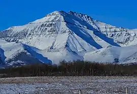
Mount Dungarvan is a 2,575-metre (8,448-foot) mountain summit located in Waterton Lakes National Park, in the Canadian Rockies of Alberta, Canada. Its nearest higher peak is Cloudy Peak, 2.8 km (1.7 mi) to the west.[1]
| Mount Dungarvan | |
|---|---|
 Mount Dungarvan | |
| Highest point | |
| Elevation | 2,575 m (8,448 ft) [1] |
| Prominence | 243 m (797 ft) [1] |
| Parent peak | Cloudy Peak (2591 m)[1] |
| Coordinates | 49°09′17″N 113°58′18″W [2] |
| Geography | |
 Mount Dungarvan Location of Mount Dungarvan in Alberta  Mount Dungarvan Mount Dungarvan (Canada) | |
| Location | Alberta, Canada |
| Parent range | Canadian Rockies |
| Topo map | NTS 82H04[2] |
| Geology | |
| Age of rock | Cambrian |
| Climbing | |
| Easiest route | Scrambling[3] |
.jpg.webp)
History
The mountain was named in 1943 after the town of Dungarvan in Ireland.[4] Dungarvan is also the Irish term for a rough and broken mountain.[5]
The mountain's name became official in 1943 by the Geographical Names Board of Canada.[2]
Geology
Like other mountains in Waterton Lakes National Park, Mount Dungarvan is composed of sedimentary rock laid down during the Precambrian to Jurassic periods. Formed in shallow seas, this sedimentary rock was pushed east and over the top of younger Cretaceous period rock during the Laramide orogeny.[6] The summit is a series of basalt pinnacles from the Purcell Sill.[5]
Climate
Based on the Köppen climate classification, Mount Dungarvan is located in a subarctic climate with cold, snowy winters, and mild summers.[7] Temperatures can drop below −20 °C with wind chill factors below −30 °C. Precipitation runoff from the mountain drains into tributaries of Waterton River.
See also
References
- "Mount Dungarvan". Bivouac.com. Retrieved 2019-01-13.
- "Mount Dungarvan". Geographical Names Data Base. Natural Resources Canada. Retrieved 2019-01-13.
- More Scrambles in the Canadian Rockies: 2nd Edition, Andrew Nugara, Rocky Mountain Books, 2014, page 47
- Place-names of Alberta. Ottawa: Geographic Board of Canada. 1928. p. 45.
- Mount Dungarvan PeakFinder
- Gadd, Ben (2008). "Geology of the Rocky Mountains and Columbias". Cite journal requires
|journal=(help) - Peel, M. C.; Finlayson, B. L. & McMahon, T. A. (2007). "Updated world map of the Köppen−Geiger climate classification". Hydrol. Earth Syst. Sci. 11: 1633–1644. ISSN 1027-5606.
External links
- National Park Service web site: Waterton Lakes National Park