Mount Loudon
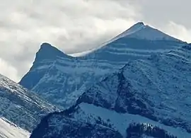
Mount Loudon is a 3,221-metre (10,568-foot) mountain summit located in the North Saskatchewan River valley of Alberta, Canada. Mount Loudon is situated in the Siffleur Wilderness Area of the Canadian Rockies. Its nearest higher peak is Mount Murchison, 15 km (9.3 mi) to the west.[1] Siffleur Mountain is located immediately northeast, and Mount Peskett immediately north. Mount Loudon can be seen from Highway 11, the David Thompson Highway. Precipitation runoff from the mountain flows north via Loudon Creek and Porcupine Creek, which are both tributaries of the North Saskatchewan River.
| Mount Loudon | |
|---|---|
 Mount Loudon | |
| Highest point | |
| Elevation | 3,221 m (10,568 ft) [1] |
| Prominence | 767 m (2,516 ft) [1] |
| Parent peak | Mount Murchison (3353 m)[1] |
| Coordinates | 51°54′58″N 116°26′43″W [2] |
| Geography | |
 Mount Loudon Location of Mount Loudon in Alberta  Mount Loudon Mount Loudon (Canada) | |
| Location | Alberta, Canada |
| Parent range | Murchison Group Canadian Rockies |
| Topo map | NTS 82N/16 |
| Geology | |
| Age of rock | Cambrian |
| Type of rock | Sedimentary |
| Climbing | |
| First ascent | 1972 A. Ridley, A. Daffern[1] |
History
The peak was named by Morrison P. Bridgland for William James Loudon (1860-1951), who was a geologist and professor at the University of Toronto.[3] Bridgland (1878-1948) was a Dominion Land Surveyor who named many peaks in the Canadian Rockies and would have known Professor Loudon while he was studying at the University of Toronto.[3][4] William James Loudon was the nephew of James Loudon (1841-1916), who was the President of the University of Toronto.[5]
The mountain's name became official in 1957 when approved by the Geographical Names Board of Canada.[2]
The first ascent of the peak was made in 1972 by Ann Ridley and Tony Daffern.[3]
Geology
Mount Loudon is composed of sedimentary rock laid down from the Precambrian to Jurassic periods that was pushed east and over the top of younger rock during the Laramide orogeny.[6]
Climate
Based on the Köppen climate classification, Mount Loudon is located in a subarctic climate with cold, snowy winters, and mild summers.[7] Temperatures can drop below -20 °C with wind chill factors below -30 °C.
References
- "Mount Loudon". Bivouac.com. Retrieved 2019-03-12.
- "Mount Loudon". Geographical Names Data Base. Natural Resources Canada. Retrieved 2019-03-12.
- Mount Loudon PeakFinder
- Mapper of Mountains M.P. Bridgland in the Canadian Rockies 1902-1930, Author I.S. MacLaren, The University of Alberta Press, ISBN 0-88864-456-6
- Mapper of Mountains M.P. Bridgland in the Canadian Rockies 1902-1930, Author I.S. MacLaren, The University of Alberta Press, ISBN 0-88864-456-6
- Gadd, Ben (2008). "Geology of the Rocky Mountains and Columbias". Cite journal requires
|journal=(help) - Peel, M. C.; Finlayson, B. L.; McMahon, T. A. (2007). "Updated world map of the Köppen−Geiger climate classification". Hydrol. Earth Syst. Sci. 11: 1633–1644. ISSN 1027-5606.
External links
- Weather forecast: Mount Loudon