Mount Sarrail
Mount Sarrail is a 3,159-metre (10,364-foot) mountain summit located in Kananaskis Country in the Canadian Rockies of Alberta, Canada. Mount Sarrail is situated 1.0 kilometre north of the Continental Divide, within Peter Lougheed Provincial Park. Its nearest higher peak is Mount Foch, 1.0 km (0.62 mi) to the southeast.[1] Mount Sarrail can be seen from Upper Kananaskis Lake and Alberta Highway 40.
| Mount Sarrail | |
|---|---|
 Mount Sarrail seen from the north | |
| Highest point | |
| Elevation | 3,159 m (10,364 ft) [1] |
| Prominence | 269 m (883 ft) [1] |
| Parent peak | Mount Foch (3194 m)[1] |
| Coordinates | 50°34′49″N 115°10′00″W [2] |
| Geography | |
 Mount Sarrail Location of Mount Sarrail in Alberta  Mount Sarrail Mount Sarrail (Canada) | |
| Location | Alberta, Canada |
| Parent range | Canadian Rockies |
| Topo map | NTS 82J/11[2] |
| Geology | |
| Age of rock | Cambrian |
| Type of rock | Limestone |
| Climbing | |
| First ascent | 1930 Katie Gardiner, Walter Feuz[1] |
| Easiest route | Scrambling |
History
The mountain was named in 1918 for General Maurice Sarrail (1856-1929), the commander of the French Third Army in World War I.[1][3]
The mountain's name was officially adopted in 1924 by the Geographical Names Board of Canada.[2]
The first ascent of the mountain was made in 1930 by Kate (Katie) Gardiner and Walter Feuz.[1] The duo also made the first ascents of nearby Mount Foch and Mount Lyautey that same year.[4]
Geology
Mount Sarrail is composed of sedimentary rock laid down during the Precambrian to Jurassic periods. Formed in shallow seas, this sedimentary rock was pushed east and over the top of younger rock during the Laramide orogeny.[5]
Climate
Based on the Köppen climate classification, Mount Sarrail is located in a subarctic climate with cold, snowy winters, and mild summers.[6] Temperatures can drop below −20° C with wind chill factors below −30° C. In terms of favorable weather, June through September are the best months to climb Mount Sarrail. Precipitation runoff from the mountain drains into tributaries of the Kananaskis River.
References
- "Mount Sarrail". Bivouac.com. Retrieved 2018-11-08.
- "Mount Sarrail". Geographical Names Data Base. Natural Resources Canada. Retrieved 2018-12-14.
- Place-names of Alberta. Ottawa: Geographic Board of Canada. 1928. p. 113.
- Mount Foch PeakFinder
- Gadd, Ben (2008). "Geology of the Rocky Mountains and Columbias". Cite journal requires
|journal=(help) - Peel, M. C.; Finlayson, B. L.; McMahon, T. A. (2007). "Updated world map of the Köppen−Geiger climate classification". Hydrol. Earth Syst. Sci. 11: 1633–1644. ISSN 1027-5606.
Gallery
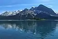 Upper Kananaski Lake with Mount Sarrail to right
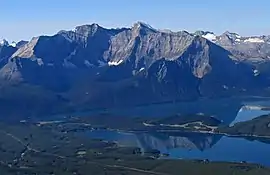 Aerial view of Foch and Sarrail with the Kananaskis Lakes
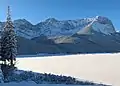 Mount Sarrail in winter
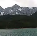 Mount Sarrail
.jpg.webp) Mount Sarrail seen from Rawson Lake
Mount Sarrail seen from Rawson Lake
External links
- Mount Sarrail weather: Mountain Forecast
- Scrambling Mount Sarrail: Explor8ion.com