Mount Wintour
Mount Wintour is a 2,700-metre (8,900-foot) ridge-like mountain summit located in the Opal Range of the Canadian Rockies of Alberta, Canada.[1] It is situated in the Kananaskis River Valley east of Lower Kananaskis Lake and Highway 40 in Peter Lougheed Provincial Park. Its nearest higher peak is Mount Jerram, 2.3 km (1.4 mi) to the east.[1] The northern end of Mount Wintour forms the south canyon wall of King Creek which is a popular ice climbing destination. There are two climbing routes to the summit, the North Ridge and the South Ridge, both rated YDS 5.4.[4]
| Mount Wintour | |
|---|---|
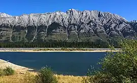 Mount Wintour, west aspect, as seen from Lower Kananaskis Lake | |
| Highest point | |
| Elevation | 2,700 m (8,900 ft) [1] |
| Prominence | 368 m (1,207 ft) [1] |
| Parent peak | Mount Jerram (2996 m)[1] |
| Listing | Mountains of Alberta |
| Coordinates | 50°41′42″N 115°04′50″W [2] |
| Geography | |
 Mount Wintour Location of Mount Wintour in Alberta  Mount Wintour Mount Wintour (Canada) | |
| Location | Alberta, Canada |
| Parent range | Opal Range[3] Canadian Rockies |
| Topo map | NTS 82J/11[2] |
| Geology | |
| Type of rock | sedimentary rock |
| Climbing | |
| First ascent | 1968 by Glen Boles and E. Peyer[1] |
| Easiest route | Climbing YDS 5.4 |
.jpg.webp)
History
The mountain was named in honor of Captain Charles John Wintour (1871–1916), Royal Navy commander of the 4th Destroyer Flotilla. He was killed when his flagship, the destroyer HMS Tipperary was sunk by the German battleship SMS Westfalen during the Battle of Jutland in World War I.[5][6] The mountain's name was officially adopted in 1928 by the Geographical Names Board of Canada.[2]
The first ascent of the peak was made in August 1968 by Glen Boles and E. Peyer via the North Ridge.[1]
Geology
Mount Wintour is composed of sedimentary rock laid down during the Precambrian to Jurassic periods. Formed in shallow seas, this sedimentary rock was pushed east and over the top of younger rock during the Laramide orogeny.[7]
Climate
Based on the Köppen climate classification, Mount Wintour is located in a subarctic climate with cold, snowy winters, and mild summers.[8] Temperatures can drop below −20 °C (−4 °F) with wind chill factors below −30 °C (−22 °F).
In terms of favorable weather, June through September are the best months to climb Mount Wintour.
Precipitation runoff from the mountain drains into the Kananaskis River.
References
- "Mount Wintour". Bivouac.com. Retrieved 2018-11-28.
- "Mount Wintour". Geographical Names Data Base. Natural Resources Canada. Retrieved 2018-11-28.
- "Opal Range". Peakbagger.com. Retrieved 2019-09-24.
- Mount Wintour SummitPost
- Place-names of Alberta. Ottawa: Geographic Board of Canada. 1928. p. 136.
- Battle of Jutland Alberta Historic Places
- Gadd, Ben (2008). Geology of the Rocky Mountains and Columbias.
- Peel, M. C.; Finlayson, B. L.; McMahon, T. A. (2007). "Updated world map of the Köppen−Geiger climate classification". Hydrol. Earth Syst. Sci. 11: 1633–1644. ISSN 1027-5606.
External links
- Charles John Wintour Charles Wintour biography
- Mount Wintour weather: Mountain Forecast