Murgul
Murgul (Laz and Georgian: მურღული/Murghuli) is a town and district of Artvin Province in the Black Sea region of Turkey.
Murgul | |
|---|---|
 Murgul | |
| Coordinates: 41°16′32″N 41°33′59″E | |
| Country | Turkey |
| Province | Artvin |
| Government | |
| • Mayor | Hasan Çavuş (AKP) |
| • Kaymakam | Faik Oktay Sözer |
| Area | |
| • District | 335.93 km2 (129.70 sq mi) |
| Elevation | 473 m (1,552 ft) |
| Population (2012)[2] | |
| • Urban | 3,051 |
| • District | 6,395 |
| • District density | 19/km2 (49/sq mi) |
| Post code | 088xx |
| Climate | Cfb |
Previously known as Damar and Göktaş Murgul is on a tributary of the Çoruh River, with mountains on all sides.
Half of the land is mountain forest and most of the other half is meadow, only 5% is planted. There are various mining and mineral operations especially copper (Murgul has Turkey's largest copper reserve) and also iron and nitrates. Murgul itself is a small town of 3,525 people.
Climate
Murgul has an oceanic climate (Köppen: Cfb).
| Climate data for Murgul | |||||||||||||
|---|---|---|---|---|---|---|---|---|---|---|---|---|---|
| Month | Jan | Feb | Mar | Apr | May | Jun | Jul | Aug | Sep | Oct | Nov | Dec | Year |
| Daily mean °C (°F) | 3.2 (37.8) |
4.1 (39.4) |
6.6 (43.9) |
10.9 (51.6) |
14.6 (58.3) |
17.9 (64.2) |
20.7 (69.3) |
20.9 (69.6) |
18.1 (64.6) |
14.0 (57.2) |
9.6 (49.3) |
5.4 (41.7) |
12.2 (54.0) |
| Average precipitation mm (inches) | 139 (5.5) |
111 (4.4) |
92 (3.6) |
82 (3.2) |
74 (2.9) |
102 (4.0) |
84 (3.3) |
105 (4.1) |
132 (5.2) |
163 (6.4) |
157 (6.2) |
173 (6.8) |
1,414 (55.6) |
| Source: Climate-Data-org[3] | |||||||||||||
Villages

Murgul in 1960's
References
- "Area of regions (including lakes), km²". Regional Statistics Database. Turkish Statistical Institute. 2002. Retrieved 2013-03-05.
- "Population of province/district centers and towns/villages by districts - 2012". Address Based Population Registration System (ABPRS) Database. Turkish Statistical Institute. Retrieved 2013-02-27.
- "Climate: Murgul". Climate-Data.org. Retrieved 12 April 2014.
External links
- Governor's Office
- the Municipality
- local information (in Turkish)
Murgul in Artvin Province of Turkey | |||||||||||||||||||||||||||
|---|---|---|---|---|---|---|---|---|---|---|---|---|---|---|---|---|---|---|---|---|---|---|---|---|---|---|---|
| Districts | 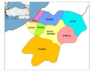 Districts of Artvin | ||||||||||||||||||||||||||
| |||||||||||||||||||||||||||
Metropolitan municipalities are bolded. | |||||||||||||||||||||||||||
This article is issued from Wikipedia. The text is licensed under Creative Commons - Attribution - Sharealike. Additional terms may apply for the media files.