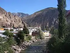
Yusufeli
Yusufeli (Armenian: Բերդագրակ, Pertaktrag; Georgian: ახალთი, Akhalti) is a town and district of Artvin Province in the Black Sea region of Turkey. It is located on the bank of Çoruh River 104 km south-west of the city of Artvin, on the road to Erzurum.
Yusufeli | |
|---|---|
 Yusufeli | |
| Coordinates: 40°49′24″N 41°32′55″E | |
| Country | Turkey |
| Province | Artvin |
| Government | |
| • Mayor | Eyüp Aytekin (AKP) |
| • Kaymakam | Emre Nebioğlu |
| Area | |
| • District | 2,270.00 km2 (876.45 sq mi) |
| Elevation | 741 m (2,431 ft) |
| Population (2012)[2] | |
| • Urban | 6,856 |
| • District | 22,234 |
| • District density | 9.8/km2 (25/sq mi) |
| Post code | 08700 |
| Climate | Cfb |
| Website | www.yusufeli.bel.tr |
The town of Yusufeli (population 5863) sits in a valley where the Çoruh River is joined by the Barhal, the surrounding countryside is a range of mountains running east to west, with villages in other valleys between the mountains. The micro climate allows the cultivation of olives, grapes, and citrus fruits, the driving forces of the economy in addition to tourism. The town can be reached by air via Erzurum Airport, 135 km (84 mi) away from Yusufeli or by road from Artvin, Erzurum and Trabzon (via İspir in Erzurum Province).
There is a widely criticised plan to dam the Çoruh at Yusufeli, which would submerge 15,000 homes.[3][4][5]
Climate
Yusufeli has an oceanic climate (Köppen: Cfb).
| Climate data for Yusufeli | |||||||||||||
|---|---|---|---|---|---|---|---|---|---|---|---|---|---|
| Month | Jan | Feb | Mar | Apr | May | Jun | Jul | Aug | Sep | Oct | Nov | Dec | Year |
| Daily mean °C (°F) | 0.5 (32.9) |
2.0 (35.6) |
5.7 (42.3) |
11.0 (51.8) |
15.0 (59.0) |
18.4 (65.1) |
21.6 (70.9) |
21.6 (70.9) |
18.4 (65.1) |
13.3 (55.9) |
8.0 (46.4) |
3.0 (37.4) |
11.5 (52.7) |
| Average precipitation mm (inches) | 80 (3.1) |
68 (2.7) |
59 (2.3) |
63 (2.5) |
65 (2.6) |
67 (2.6) |
49 (1.9) |
54 (2.1) |
68 (2.7) |
96 (3.8) |
94 (3.7) |
95 (3.7) |
858 (33.7) |
| Source: Climate-Data.org[6] | |||||||||||||
History
The history of Yusufeli, formerly Perterek or Pertarek, is traced to 3000 BC, the Bronze Age. The area has since been inhabited by Hurri, Urartu, Persians, Armenians, Ancient Romans, Byzantines and Georgians. In the Turkish era the area has been settled by Seljuks, Saltuks, Ilkhanates, Tamerlan, Akkoyunlu, Safevids and the Ottoman Empire. In the kingdom of Armenia in antiquity it was part of Tayk province, known as the Canton of Arsiats por.[7] In 1879 the area was the district of Kiksim in the county of Çıldır. Then following the war between the Ottoman Empire and Russia it became a county of Erzurum. most of the population is descended from Armenians who were forced to convert to Islam in the 1700s.[8]
Because of the rocky geography it was difficult for people from all villages to reach the city center, so a local district was established centred on Ögdem, but this was still inaccessible so Kılıçkaya (Ersis) became the center of county. Ersis means "a place where no boys live", so-called because so many sons of the district were lost in the Russo-Turkish War of 1878 and First World War. In the year 1912 the county name became Yusuf İli, i.e. "province of Yusuf" so the name Kiskim should not be confused with the name Keskin which was a county of Ankara at that time.
Culture
The folk music and culture is typical of the Black Sea region featuring the clarinet type zurna, a drum and bagpipes.
There are a number of historical Georgian churches in the valleys of Yusufeli, including the ruins of the Four Churches (Dört Kilise) in a village off the road to İspir (Map).
Places of interest
There are many medieval forts and Georgian churches in the valleys of Yusufeli. Some of them:[9]
- Armashen fortress
- Ersis fortress
- Nihak fortres
- Oshnak fortress
- Ishan monastery
- Ogdem fortress
- Peterek fortress
- Parhal monastery
- Savangin, a pre-historical cave with an inscription written in an undeciphered writing system
Notable natives
- The singer and politician Zülfü Livaneli was born into a family from Yusufeli.
- The mayor of Istanbul, Kadir Topbaş was born in Yusufeli.
References
- "Area of regions (including lakes), km²". Regional Statistics Database. Turkish Statistical Institute. 2002. Retrieved 2013-03-05.
- "Population of province/district centers and towns/villages by districts - 2012". Address Based Population Registration System (ABPRS) Database. Turkish Statistical Institute. Retrieved 2013-02-27.
- The Yusufeli dam project
- Friends of the Earth: Campaigns: Corporates: AMEC and Spie pull out of Yusufeli Dam
- Balfour Beatty withdraws support for the Ilisu Dam Archived April 15, 2007, at the Wayback Machine
- "Climate: Yusufeli". Climate-Data.org. Retrieved 12 April 2014.
- http://www.bvahan.com/armenianway/great_armenia/Main_Eng/Maps_Eng/Maps_prov_Eng/Map_Eng.html
- Ինճիճեան Ղ., Աշխարհագրութիւն չորից մասանց աշխարհի՝ Ասիոյ, Եւրոպիոյ, Ափրիկոյ և Ամերիկոյ: Մասն առաջին. Ասիա, հտ. Ա, Վենետիկ, 1806, էջ 93
- Yusuefli forts and monasteries (Turkish) Archived November 22, 2008, at the Wayback Machine
External links
Yusufeli in Artvin Province of Turkey | |||||||||||||||||||||||||||
|---|---|---|---|---|---|---|---|---|---|---|---|---|---|---|---|---|---|---|---|---|---|---|---|---|---|---|---|
| Districts | 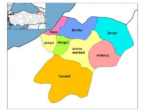 Districts of Artvin | ||||||||||||||||||||||||||
| |||||||||||||||||||||||||||
Metropolitan municipalities are bolded. | |||||||||||||||||||||||||||