Nagarukhra, Nadia
Nagarukhra (pronounced [/nəgɑ:rʌkrə/]) is a town and a gram panchayat within the jurisdiction of the Nagarukhra police station in the Haringhata CD Block in the Kalyani subdivision of the Nadia district in the Indian state of West Bengal.[3]
Nagarukhra | |
|---|---|
Town | |
 Dakshina Kali Mata at Sadar Kalibari | |
.png.webp) Coat of Arms or Seal | |
 Nagarukhra Location in West Bengal, India  Nagarukhra Nagarukhra (India) | |
| Coordinates: 22.94°N 88.66°E | |
| Country | |
| State | |
| Division | Presidency |
| District | Nadia |
| Subdivision | Kalyani |
| CD Block | Haringhata |
| Government | |
| • Type | Gram Panchayat |
| • Body | Nagarukhra-I Gram Panchayat Nagarukhra-II Gram Panchayat |
| • MLA | Nilima Nag (Mallick), (AITC) |
| • MP | Shantanu Thakur, (BJP) |
| Area | |
| • Total | 29.87 km2 (11.53 sq mi) |
| Elevation | 12 m (39 ft) |
| Population (2011) | |
| • Total | 46,914 |
| • Density | 1,600/km2 (4,100/sq mi) |
| Languages | |
| • Official | Bengali[1][2] |
| • Additional official | English[2] |
| Time zone | UTC+5:30 (IST) |
| PIN | 741257 |
| Telephone code | +91 3473 |
| ISO 3166 code | IN-WB |
| Vehicle registration | WB-51, WB-52 |
| Lok Sabha constituency | Bangaon |
| Vidhan Sabha constituency | Haringhata |
| Website | www |
Geography
Nagarukhra is located at 22.94°N 88.66°E.[4] It has an average elevation of 12 metres (39 ft).
Nagarukhra is bounded by the Jamuna River on the North. It is approximately 65 km far from district headquarter, Krishnagar and approximately 50 km. far from the state capital, Kolkata.
Demographics
According to the 2011 Census of India, Nagarukhra had a total population of 46,914.[5]
| Area | Gram Panchayat | Town/Village | Population |
|---|---|---|---|
| Ukrah | Nagarukhra-I | Nagarukhra | 13,548 |
| Simul Pukharia | Nagarukhra-I | Nagarukhra | 1,262 |
| East Satberia | Nagarukhra-I | Nagarukhra | 1,159 |
| Goaldob | Nagarukhra-I | Nagarukhra | 4,883 |
| Dasbaria | Nagarukhra-I | Nagarukhra | 1,734 |
| Chak Bhandarkona | Nagarukhra-I | Nagarukhra | 265 |
| Bhandarkona | Nagarukhra-II | Nagarukhra | 1,061 |
| Chanda | Nagarukhra-II | Nagarukhra | 3,692 |
| Dighalgram | Nagarukhra-II | Nagarukhra | 5,395 |
| Hapania | Nagarukhra-II | Nagarukhra | 2,494 |
| Jhikra | Nagarukhra-II | Nagarukhra | 3,214 |
| Singa | Nagarukhra-II | Nagarukhra | 3,882 |
| Parulia | Nagarukhra-II | Nagarukhra | 1,766 |
| Sonakur | Nagarukhra-II | Nagarukhra | 1,886 |
| Thansara | Nagarukhra-II | Nagarukhra | 1,198 |
| Total | 46,914 (Census Data: 2011)[6][7] |
According to the 2011 Census of India, 93.38% of the population is Hindu, 5.07% Muslim, 1.49% Christian and 0.06% is others. The remainder of the population is uncatalogued.[8]
Civic Administration
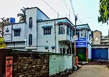
Police station
Nagarukhra Police Station is a newly established Juridical administrative Police Department in Nagarukhra. This Police Station has jurisdiction over Nagarukhra and its neighbouring areas. The New Police Station located on the bank of Jamuna River.
Post Office
Nagarukhra has a delivery sub post office, with PIN 741257 in the South Presidency Division of Nadia district in Kolkata region. The other post offices are under Nagarukhra Sub P.O, with the same PIN is Dighalgram, Haripukuria, Kasthodanga, Mahadebpur and Nimtala bazar.[9]
Electricity Board
The WBSEDCL (West Bengal State Electricity Distribution Company Limited) is responsible as a leading Power Utility services organization of Nagarukhra. This Government based electricity company serves electric service to the entire area and households. It also serves electric connection to its neighbour localities. Nagarukhra wbsedcl CCC[10] is the Regional control office for WBSEDCL Customer Care.
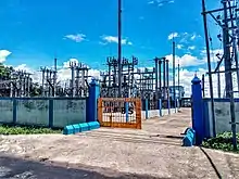
Nagarukhra 33/11 KV Substation is a power station, from where the entire area and its neighbours get electric supply.
Education
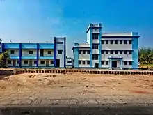
Nagarukhra have three Higher Secondary Schools.
_-_Wide_Angle_View.jpg.webp)
- Nagarukhra High School is the oldest Higher Secondary school of this area.
.jpg.webp)
- Nagarukhra Kshetra-Mohan Girls' High School is the Girls' Higher secondary school as well.
.jpg.webp)
- Dighalgram Netaji Vidyapith is also a higher secondary school at Dighalgram, Nagarukhra-II.
These schools are undertaken by West Bengal Council of Higher Secondary Education,[11] except that there are many kindergarten schools are available in this area.
Transport
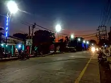
Kanchrapara - Nagarukhra - Bongaon Intercity Roadway[12] passing through Nagarukhra. This road is connected with National Highway 112 (India) to the east, with National Highway 12 (India) and Kalyani Expressway to the west directly. This road is also a shortest roadway to access the Petrapole-Bangladesh Border for Border Security Force and Indian Army. This road also connects many different villages and towns. This road is intersect with other three major roads in Nagarukhra, Ashoknagar-Kalyangarh Road intersection at near Nagarukhra Kali Bari; Nimtala Road intersection at new market chowmatha crossing and Habra Road intersection at near Anandamoyee Kali Mandir Tinmatha More.
Bus services
Nagarukhra has various bus route services to connect with different places.
Private bus lines
- 22. Nagarukhra – Kanchrapara via Duttapara, Fatehpur, Haringhata, Barajaguli, BCKV, Mohanpur, Kampa Army Camp, KPA Station.
- 22. Nagarukhra – Kalyani via Duttapara, Fatehpur, Haringhata, Barajaguli, BSF Camp,7 No., AIIMS-Kalyani, Anandapur.
- 19B. Gaighata – Ranaghat via Jaleswar, Hanspur, Nagarukhra, Haringhata, Birohi, Chakdaha, Simurali, Ranaghat.
- 95. Bongaon – Ashoknagar via Gopalnagar, Palla, Nahata, Chowberia, Nimtala, Kasthadanga, Nagarukhra, Jhikra, Habra.
MN series
Bus transit without number
- Nagarukhra – Kolkata.
- Thakurnagar – Nabadwip Ghat.
- Thakurnagar – Kalna Ghat.
WBTC route line
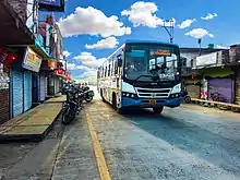
Bus Terminals
- Public Bus Terminus:
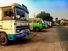
Nagarukhra Public Bus Terminus (NPBT) is situated on North bank of Jamuna River(West Bengal), beside the Nagarukhra Police Station's Gate no.1. The bus depot was built up in 2016.
Air
Netaji Subhas Chandra Bose International Airport (IATA: CCU, ICAO: VECC) is the nearest airport. The airport is located approximately 45 kilometres (28 mi) from Nagarukhra.
References
- "52nd Report of the Commissioner for Linguistic Minorities in India" (PDF). Ministry of Minority Affairs. p. 85. Archived from the original (PDF) on 25 May 2017. Retrieved 29 August 2019.
- "Fact and Figures". Wb.gov.in. Retrieved 29 August 2019.
- "Nagarukhra detail osmap". Openstreetmap.org.
- "Nagarukhra Weather Forecast". Accuweather.
- "Census digital library". Census-2001. Retrieved 12 April 2004.
- "Nagarukhra I areas". census2011. Retrieved 4 October 2020.
- "Nagarukhra II areas". census2011. Retrieved 4 October 2020.
- "C1 Population by Religious Community". West Bengal. Register General and Census Commissioner, India. Retrieved 2 May 2017.
- "Nagarukhra PIN Code". pincode.in-server.com. Retrieved 28 September 2020.
- "Tender for Nagarukhra WBSEDCL Construction". tenderdetail.com.
- "WBCHSE Schools in Nadia Dist".
- "Kanchrapara - Nagarukhra - Bongaon Highway". OpenstreetMap.
External links
Cities, towns and locations in Nadia District | |||||||||
|---|---|---|---|---|---|---|---|---|---|
| Cities, municipal and census towns |
| ||||||||
| Locations other than cities and towns |
| ||||||||
| Related topics |
| ||||||||
| Wikimedia Commons has media related to Nagarukhra. |
 Nagarukhra travel guide from Wikivoyage