Nanjemoy Formation
The Nanjemoy Formation is a geologic formation pertaining to both the Wilcox Group and the Pamunkey Group of the eastern United States, stretching across the states of Virginia, Maryland, and District of Columbia. The formation crops out east of the Appalachians and dates back to the Paleogene period. Specifically to the Ypresian stage of the Eocene epoch, about 55 to 50 Ma or Wasatchian in the NALMA classification, defined by the contemporaneous Wasatch Formation of the Pacific US coast.
| Nanjemoy Formation Stratigraphic range: Ypresian (Wasatchian) ~54.5–50.3 Ma | |
|---|---|
| Type | Formation |
| Unit of | Pamunkey Group |
| Sub-units | Woodstock & Potapaco |
| Underlies | Piney Point & Calvert |
| Overlies | Aquia & Marlboro Clay |
| Thickness | About 20 m (66 ft) |
| Lithology | |
| Primary | Sandstone, claystone |
| Other | Marl, limestone |
| Location | |
| Coordinates | 38.8°N 76.7°W |
| Approximate paleocoordinates | 39.1°N 60.8°W |
| Region | |
| Country | |
| Extent | Extent |
| Type section | |
| Named for | Nanjemoy Creek Etymology |
| Named by | Clark & Martin |
| Year defined | 1901 |
 Nanjemoy Formation (the United States) 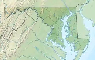 Nanjemoy Formation (Maryland) | |
The about 20 metres (66 ft) thin formation crops out in a narrow irregular band and only in certain of the many creeks of the Maryland peninsula and on the southern side of the Potomac River in Virginia. The two members the formation was divided into by Clark and Martin in 1901; Potapaco and Woodstock, represent different phases in the basin history. The lower Potapaco Member is much more clayey, described as marl, than the upper Woodstock Member, probably characteristic of less storm influences in the shallow shelf sediments.
The formation has provided a wealth of fossils of mainly fish, but also mammals, reptiles, birds and flora. The presence of the sharks Otodus obliquus and Carcharocles aksuaticus, as well as various other shark and ray species are notable. Crocodylian, snake, turtle, mammal, and bird remains have all been found in the Nanjemoy Formation.[1]
Etymology
Nanjemoy is probably an Ojibwe word, meaning "one goes downward",[2] representing the many rivers and creeks in the wet watershed of Chesapeake Bay, an area originally inhabited by the Algonquin-speaking Nanticoke and Powhatan.[3] The formation is named after Nanjemoy Creek, a left tributary of the Potomac River.[2]
Wicomico is the name of two separate rivers, one on Maryland's Eastern Shore, Wicomico River (Maryland eastern shore), and another in Southern Maryland, Wicomico River (Potomac River tributary), and is the name of a small thoroughfare in southeastern Charles County.[2]
The reason this term appears in three different places in the state simply means that the people living there when the English barged in were trying to tell them it was a nice place to live.[2]
Wigh or wik, representing "pleasant" and accomico "dwelling, village" was the native's way of telling the Europeans they liked living there.[2]
Geography is all-defining in these areas,[4] Hills, valleys and rivers received their descriptive name in the local languages of the world. The global phenomenon of naming geographical features; our leading highways for millennia, as descriptive as possible. In the Algonquin-speaking area of the present-day Eastern United States, for instance in western Charles County; Chicamuxen means "there lies the high ground."[2]
Potapaco was an early name for Port Tobacco Creek,[5] that was named after the people, also known as the Piscataway.
Nanjemoy, which may contain elements of Ojibwa, by contrast means "one goes downward."[2]
Mattawoman, found in Charles, Prince George's and on the Eastern Shore, has remnants of not only Algonquin, but Fox and Ojibwa as well, and translates to "where one goes pleasantly."[2]
Definition
_(14746338736).jpg.webp)
The Nanjemoy Formation was defined by Clark and Martin in 1901, as part of the mapping by the Maryland Geological Survey. The Nanjemoy Formation was divided into two members, the lower or Potapaco, and the upper or Woodstock. The main lithologic distinction is that the lower part of the Nanjemoy is much clayey than the upper part. In the subsurface, the distinction between the members is less evident than in outcrops, especially in Maryland, so the formation has been left undivided.[6]
In the outcrops along the Potomac River near Popes Creek, the contact between the Woodstock and Potapaco at about 10 feet (3.0 m) above the water level.[6]
Extent
 FS Ws Nanjemoy Formation (Virginia) |
NC Nanjemoy Formation (Maryland) |
 |
| Notable sites of the Nanjemoy Formation in the Potomac River basin in northeastern Virginia and western Maryland NC - Nanjemoy Creek, Ws - Woodstock, FS - Fisher/Sullivan site | ||
The Nanjemoy Formation, represented as Tn on the geologic map of the Washington West 30' × 60' Quadrangle, Maryland, Virginia, and Washington D.C., restricted to the southeastern side of the Potomac Basin represented in the quadrangle.[7] Scott (2005) in his thesis included a map showing the thin bands of outcrops of both the underlying Marlboro Clay and the Nanjemoy Formation, restricted to the many creeks feeding the Chesapeake Bay.[8]
The Nanjemoy Formation (Eocene), the Marlboro Clay (Paleocene), and the Aquia Formation (Paleocene) are present in the westernmost part of the Potomac channel.[9]
The outcrop area of the formation is designated Nanjemoy Wildlife Management Area.
Geology
Learn more Geology of the Appalachians under that article.
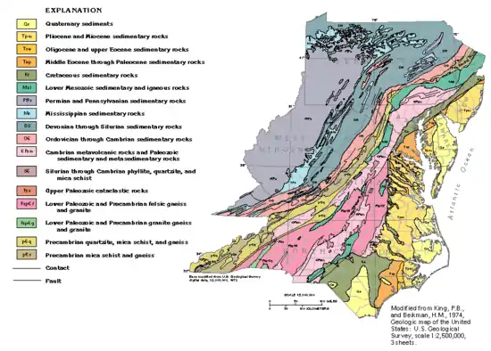
Geologically, the area of deposition of the Nanjemoy Formation is part of the Atlantic coastal plain province.
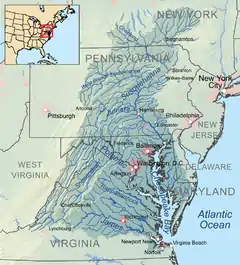
Potomac Basin
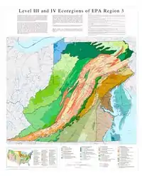
The Potomac Basin represents the central part of the Atlantic coastal plain that stretches along the Atlantic coast of Canada and the United States. The basin stretches across parts of four states (Maryland, Pennsylvania, Virginia and West Virginia), as well as the District of Columbia. This area is also called the Potomac watershed. It includes all of the land area where water drains towards the mouth of the Potomac – the point where the river spills into the Chesapeake Bay. The Potomac River basin is the 2nd largest watershed in the Chesapeake Bay watershed.[10]
The land of the Potomac Basin varies a great deal from its sources to its mouth, and so do its people. It is difficult to fully describe the Potomac and its people because of their variety and because they are both constantly changing. With that in mind, here is a current snapshot of the basin’s land, its people, and its water.
- Land
The drainage area of the Potomac includes 14,670 square miles in four states: Virginia (5,723 sq. mi.), Maryland (3,818 sq. mi.), West Virginia (3,490 sq. mi.), Pennsylvania (1,570 sq. mi.), and the District of Columbia (69 sq. mi.). The basin’s total area varies depending on map projection used. The basin lies in five geological provinces: the Appalachian Plateau, the Ridge and Valley, Blue Ridge, Piedmont Plateau, and Coastal Plain. The Potomac meanders over 383 miles from Fairfax Stone, West Virginia to Point Lookout, Maryland. The river’s distance will vary with map projection and location of measuring tool in the river (ie. middle of the river, Maryland shoreline, Virginia shoreline).
Based on information from the NLCD 2011 database, the majority of the basin’s land area is covered by forests at 54.6 percent of the land area. Developed land makes up 14.1 percent of the basin’s land area, while agriculture covers 26.0 percent. Water and wetlands make up 5.9 percent of the basin’s land area.
The Potomac's major tributaries include: the Anacostia River, Antietam Creek, the Cacapon River, Catoctin Creek, Conococheague Creek, the Monocacy River, the North Branch, the South Branch, the Occoquan River, the Savage River, the Seneca Creek, and the Shenandoah River. Visit our maps section to see these watersheds in detail.
- People
The population of the basin is approximately 6.11 million (2010 estimated census). The population has increased by about five percent since 2005. The following information is based on 2010 estimated census data.
Stratigraphy
The Nanjemoy Formation belongs to two geologic groups; the Wilcox Group of the Gulf of Mexico Basin in the southernmost surface expression of the formation and the Pamunkey Group in the northern and central portions from Maryland in the north through Virginia and the Carolinas. Both geologic groups have been dated to the early Paleogene; the Paleocene and Eocene periods, or in the commonly used NALMA classification; Wasatchian, defined by the age-equivalent Wasatch Formation of Wyoming.
The third-oldest unit in the Pamunkey Group is the Nanjemoy Formation that overlies the Marlboro Clay and is partly overlain by the Piney Point Formation and in many areas covered by the Miocene Calvert Formation, separated by an unconformity representing about 34 Ma.
The upper surface reaches an elevation of about 50 metres (160 ft) and is overlain in most places by the Calvert Formation (Tc). The unit is present only in the southeastern part of the map area of Washington D.C., and it reaches a maximum thickness of about 20 metres (66 ft).[7]
Petrology
The formation comprises glauconitic quartz sand, dark-grayish-green to olive-black (tan to orange where weathered), fine to medium-grained; and dark-greenish-gray silty clay. In places, the sand is very muddy or contains many small quartz pebbles, and the clay is silty or sandy. Both lithologies contain richly fossiliferous beds including abundant mollusk shells.[7]
Robert E. Weems and Gary J. Grimsley (1999) described the geology of the Fisher/Sullivan site in Virginia as:[11]
| Formation | Member | Bed | Lithology | Thickness (ft) |
|---|---|---|---|---|
| Nanmejoy | Potomac | B | Sand, dominantly quartz, fine-grained, well sorted, micaceous, glauconitic, medium-brown, spa$e wood fragments present and molds and casts of shells | 1 |
| Sand, dominantly quartz, dominantly fine-grained but with abundant rounded grains of medium- to coarse-grained quartz and scattered rounded quartz granules and pebbles to 1 cm (0.39 in) in diameter, glauconitic, medium-brown, contains abundant shell casts of Venericardia potapacoensis and abundant teeth and bones | 2 | |||
| Unconformity | ||||
| Nanmejoy | Potomac | A | Sand, dominantly quartz, very fine- to fine-grained, bioturbated and massive, glauconitic, medium-brownish- gray, scattered wood fragments throughout and scattered molds and casts of shells, upper foot bioturbated and burrows filled with matrix from above bed, basal foot contains abundant medium- to coarse-grains and is more glauconitic than sediments above | 15 |
| Marlboro Clay | Clay, silty, finely micaceous, greasy, sticky, lightgray, upper two feet intensely burrowed and burrows filled with matrix from bed above | 8 | ||
| Total section exposed | 26 | |||
Paleogeography
Climate
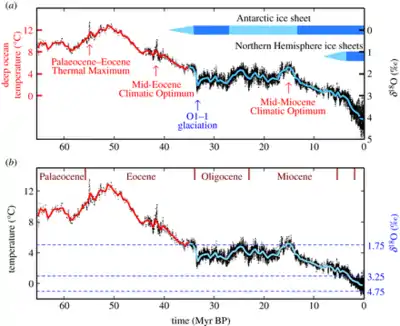
The climate of the Early Eocene and Late Paleocene was very hot and rich in CO2. Based on the fossils of the terrifyingly large Titanoboa cerrejonensis, dating to the latest Paleocene, a body mass of 1,135 kilograms (40,000 oz) for the snake was estimated. This enormous size could only have been possible under the most ideal conditions for such large species, around 6 to 8 Ma after the extinction of the previous megafauna; the dinosaurs. The climate of the Neotropical biome was estimated at 34 °C (93 °F) average yearly temperatures and 2000 ppm atmospheric CO2.[12]
Depositional environment
The depositional environment of the Nanjemoy Formation is mostly shallow shelf. The more clayey beds suggest an area or time of quiet water, not affected by waves, tides, or current activity; intercalated sandier zones may reflect the higher energy of waves or currents during episodic storms. Its regional dip is eastward at 15–20 ft per mile (3-3.5 m/km).[6]
Paleontology
The floral and faunal assemblage of the Nanjemoy Formation is very varied and provides an insight into the paleobiological and paleoclimatological environment of the early Eocene. Fossils of bivalves, sharks, rays, actinopterygian fishes, reptiles, birds and mammals, and of fruits and seeds are common in the Potapaco Member. More than 2000 vertebrate coprolites from the Potapaco Member at the Fisher/Sullivan Site in Virginia were analyzed by Dentzien Dias et al. (2019). The chemical composition (phosphatic), inclusions and morphology suggest that only carnivorous scats were preserved.[13]
All Nanjemoy coprolites were produced by fishes; chondrichthyans, Carcharhiniformes, and lamniform sharks, probably the genus Carcharias. Other morphotypes were produced by actinopterygian fishes. The surface marks and the lack of flatness on most coprolites suggests early lithification of the Potapaco Member.[13]
Main fossil sites of the Nanjemoy Formation are
- Nanjemoy Creek; Charles County, MD[14]
- Woodstock; King George County, VA[15][16][17]
- Fisher/Sullivan; Stafford County, VA[18][19]
- Evergreen Plantation; Prince Charles County, VA[20]
Fisher/Sullivan site, VA
In October 1990, Mr. Richard Brezina of the Maryland Geological Society discovered an important fossil site east of Fredericksburg, in eastern Stafford County, Virginia. This locality, along an unnamed tributary of Muddy Creek, became known as the Fisher/Sullivan site in recognition of its principle landowners.[21]
Mr. Brezina immediately realized that the site was exceptional, because it yielded numerous shark teeth and other vertebrate remains from the sands and gravels in the unnamed tributary. Mr. Brezina notified other members of the Maryland Geological Society, and together members of the MGS began to screen stream sediments at the site for more shark teeth and other remains. It soon became apparent, from the types of teeth that were being found and from the color and texture of the sediments in the banks of the creek, that the fossils were being reworked from glauconitic ("greensand") horizons of the Lower Tertiary (Paleocene-Eocene) Pamunkey Group.[21]
Because the Pamunkey Group previously had yielded only sparse vertebrate remains, it seemed reasonable to suspect that this locality was scientifically important.[21]
Fossil content
Among many invertebrates (gastropods, bivalves, corals, bryozoans), the following fossils have been reported from the Nanjemoy Formation:
| Group | Fossils | Member | Site | Images | Refs |
|---|---|---|---|---|---|
| Mammals | Peradectes guottai, Pisodus oweni, cf. Esthonyx sp., aff. Homogalax sp., Miacidae indet., Nyctitheriidae indet., ?Ischyromyidae indet. | Potapaco | Fisher/Sullivan, Prince Charles County, VA | [19] | |
| cf. Hyopsodus sp. | 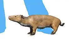 | ||||
| cf. Palaeosinopa sp. |  | ||||
| Birds | ?Odontopteryx sp. |  | |||
| ?Graculavidae indet., Scolopaci indet., ?Steatornithidae indet., ?Caprimulgidae indet., Aegialornithidae indet., ?Phoenicopteridae indet. Eostrix gulottai | |||||
| Reptiles | cf. Eosphargis gigas, ?Dollochelys sp., Puppigerus camperi, cf. Trionyx pennatus, Eosuchus lerichei, Thoracosaurus neocesariensis, Parophisaurus mccloskeyi, Palaeophis toliapicus, Palaeophis virginianus, Palaeophis casei | ||||
| Palaeophis grandis, Palaeophis sp. | Woodstock | King George County, VA |  | [15] | |
| Fish | Myliobatis dixoni, Odontaspis macrota | [16] | |||
| Lamna cuspidata, Galeocerdo latidens | [17] | ||||
| Hypotodus verticalis | Nanjemoy Creek, MD | [14] | |||
| Odontaspis macrota, | Evergreen Plantation, VA | [20] | |||
| Otodus obliquus | Potapaco | Evergreen Plantation Fisher/Sullivan, VA | 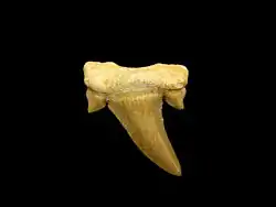 | [20][19] | |
| Isistius trituratus, Squatina prima, Squalus crenatidens, Triakis wardi, Rhinobatus bruxelliensis, Pristis luthami, Propristis schweinfurthi, Anoxypristis macrodens, Anoxypristis sp., Coupatezia woatersi, Hypolophodon sylvestris, Myliobatis latidens, Myliobatis dixoni, Myliobatis striatus, Archaeomanta melenhorsti, Burnhamia daviesi, Aetomylaeus sp., Aetobatis irregularis, Rhinoptera sherboni, Meridiania conyexa, Heterotorpedo fowleri, Jacquhermania duponti, Echinorhinus priscus, Striatolamia macrota, Anomotodon novus, Serratolamna aschersoni, Serratolamna lerichei, Cretolamna appendiculata, Odontaspis winkleri, Carcharias hopei, Carcharias teretidens, Palaeohypotodus ratoti, Physogaleus secundas, Abdounia recticona, Abdounia minutissima, Abdounia beaugei, Eugaleus ypresiensis, Pachygaleus lefevrei, Palaeogaleus vincenti, Heterodontus lerichei, Scyliorhinus gilberti, Orectolobidae indet., Ginglymostoma africanam, Ginglymostoma subafricanum, Nebrius thielensis, Nebrius serra, Palaeorhincodon wardi, Hexanchus sp., Acipenser sp., Cylindracanthus rectus, Voltaconger latispinus, cf. Bolcyrus formosissimus, Phyllodus toliapicus, Paralbula marylandica, Egertonia isodonta, Albula eppsi, Teratichthys antiquitatus, Sphyraena bognorensis, Acanthocybium proosti, Sarda delheidi, Scomberomorus sp., Scomberomorus bleekeri, Scombrinus sp., Aglyptorhynchus veneblesi, Trichiurides sagittidens, Sullivanichthys mccloskeyi, Fisherichthys folmeri, Prolates dormaalensis, Cyclopoma folmeri, cf. Sciaenurus bowerbanki, ?Arius sp., Brychaetus muelleri, Pycnodus sp., Amia sp., Lepisosteus sp., Megalopidae indet., Ostraciidae indet., ?Perciformes indet. | Potapaco | Fisher/Sullivan, VA | [19] | ||
| Flora | Canarium parksii, Iodes multireticulata, Nipa burtini, Premontria degremonti, Symplocos grimsleyi, Tinospora folmerii, Wetherellia marylandica, cf. Coturnipes cooperi, Ampelopsis sp., Nyssa sp., Vitis sp., ?Beckettia sp. | [18][19] | |||
Contemporaneous fossiliferous units
Ypresian, Wasatchian and Casamayoran formations:[22]
- North America
- Manasquan Formation, New Jersey
- Bashi Formation, Alabama
- Hatchetigbee Bluff and Sabinetown Bluff Formations, Southeastern United States
- Klondike Mountain Formation, Republic & Curlew Basin, Washington State
- Crescent Formation, Washington
- Allenby and Coldwater Beds Formations and Ootsa Lake and Kamloops Group, British Columbia
- Lookingglass and Umpqua Formations, Oregon
- Wasatch Formation, and Tatman, Willwood, Wind River, Pass Peak and Indian Meadows Formations, Wyoming
- Challis Volcanics Formation, Idaho
- Golden Valley Formation, North Dakota
- Claron Formation, Utah
- Green River Formation, western United States
- Coalmont, Cuchara and DeBeque Formations, Colorado
- Sheep Pass Formation, Nevada
- San Jose and Galisteo Formations, New Mexico
- Capay, Juncal, Llajas, Maniobra, Matilija, Meganos & Santa Susana Formations, California
- Margaret Formation, Northwest Territories and Nunavut, Canada
- Mokka Fiord Formation, Remus Basin, Northern Territories
- Bateque and Las Tetas de Cabra Formations, Baja California
- Hannold Hill and Pendleton Ferry Formations, Gulf of Mexico
- Adjuntas and Indio Formations and Lechería Limestone, Mexico
- Descartes Formation, Costa Rica
- Stettin Formation, Jamaica
- Scotland Formation, Barbados
- Lizard Springs Formation, Trinidad and Tobago
- South America
- Bogotá Formation, Altiplano Cundiboyacense, Colombia
- Cerrejón Formation, Cesar-Ranchería Basin, Colombia
- Los Cuervos Formation, Catatumbo, Cesar-Ranchería and Llanos Basins, Colombia
- Caballas Formation, Pisco Basin, Peru
- Chacras and Negritos Formations, Peru
- Fonseca Formation, Brazil
- Itaboraí Formation, Itaboraí Basin, Brazil
- Lumbrera Formation, Salta Basin, Argentina
- Laguna del Hunco Formation, Cañadón Asfalto Basin, Argentina
- Huitrera Formation, Neuquén Basin, Argentina
- Sarmiento and Ventana Formations, Golfo San Jorge Basin, Argentina
- Las Flores Formation, Austral Basin, Argentina
- Antarctica
- lower La Meseta Formation
- Europe
- Kortrijk Clay, Bruxellian Formation and Dormaal Member of Tienen Formation, Belgium
- Sables de Pierrefonds, Calcares marins à alvéolines, Lignites de Soissonais, Marnes de Foncouverte, Argiles d'lignite du Soissonnais, Marnes de Gan and Carcassonne Group, France
- Moler, Ølst and Fur Formations, southeastern North Sea Graben, Denmark
- Balder Formation, Faroe-Shetland Basin, North Sea
- London Clay, Bagshot Formation, London Basin, England
- Oldhaven Formation, England
- Roterzschicht Formation, Austria
- Lefkara Formation, Cyprus
- Silveirinha Formation, Portugal
- Armàncies, Corca and Roda Formations, Spain
- Pesciara Formation, Italy
- Monte Spilecco, Monte Bolca, Italy
- Asia
- Çeltek, Kirkkavak and Yoncali Formations, Turkey
- Umm al-Rua’us Formation, Saudi Arabia
- Alai Beds, Kyrgyzstan
- Ghazij, Mami Khel and Shekhan Formations, Pakistan
- Cambay Shale, Naredi and Subathu Formations, Sylhet Limestone and Upper Ranikot Group, India
- Dabu, Qimugen Formation and Ulunguhe Formations, Xinjiang, China
- Arshanto Formation, Inner Mongolia, China
- Yangxi Formation, Hubei, China
- Lingcha Formation, Hunan, China
- Wutu Formation, Shandong, China
- Tadushi Formation, Primorsky Krai, Russia
- Takaradayskaya Formation, Sakhalin, Russia
- Ommai Formation, Kamchatka, Russia
- Akasaki Formation, Japan
- Africa
- Esna, El Rufuf Formation and Thebes Formations, Egypt
- Al Jir and Jdeir Formations, Libya
- Gafsa Phosphates Formation, Tunisia
- Ait Ouarhitane Formation, Morocco
- Tamaguélelt Formation, Mali
- Thies Formation, Senegal
- Auradu Formation, Somalia
- Landana Formation, Cabinda, Angola
- Oceania
- Red Bluff Tuff Formation, Tutuiri Greensand and Tumaio and Te Whanga Limestones, New Zealand
- Macquarie Harbor Formation, Tasmania, Australia
- Dilwyn Formation, Victoria
- Redbank Plains Formation, Queensland
- Jubilee Member of Cardabia Formation, Western Australia
See also
- Regional geology
- List of fossiliferous stratigraphic units in Maryland, Virginia
- Geology of Chesapeake Bay, Appalachians
- Chesapeake Bay impact crater
- Paleontology
References
- Weems & Grimsley, 1999
- Joseph Norris, TheBayNet, 2016
- Library of Congress - National atlas. Indian tribes, cultures & languages: United States
- Robert Kaplan, 1991, p.
- UoC, 1938, p.1713
- McCartan et al., 1995, p.17
- Geologic Map MD; VA; D.C., USGS, 2017
- Scott, 2005, p.67
- McCartan et al., 1995, p.7
- Nardolilli et al., 2020
- Weems & Grimsley, 1999, p.5
- Head et al., 2009
- Dentzien Dias et al., 2019
- Nanjemoy Creek at Fossilworks.org
- Woodstock at Fossilworks.org
- Woodstock 2 at Fossilworks.org
- Woodstock 3 at Fossilworks.org
- Fisher/Sullivan 1 at Fossilworks.org
- Fisher/Sullivan 2 at Fossilworks.org
- Evergreen Plantation 1 at Fossilworks.org
- Weems & Grimsley, 1999, p.3
- Fossilworks.org
Bibliography
- Nanjemoy
- Norris, Joseph (23 October 2016). "Do you know the Indian name places in Maryland?". TheBayNet.com. Retrieved 2020-03-06.
- Wilmarth, M. Grace (1938). "Lexicon of geologic names of the United States - Part 2 M-Z". USGS Bulletin. 896: 1–2396. Retrieved 2020-03-08.
- Potomac Basin
- Nardolilli, Mike; Bolle, Robert; Park, Bo; Wang, Wendy; Hunter, DeeDee; Dalpra, Curtis; Bourassa, Renee (2020). "Potomac Basin Facts". Interstate Commission on the Potomac River Basin (ICPRB): 1. Retrieved 2020-03-06. Cite journal requires
|journal=(help)
Geology publications
- Lyttle, Peter T.; Aleinikoff, John N.; Burton, William C.; Crider Jr., E. Allen; Drake Jr., Avery A.; Froelich, Albert J.; Wright Horton Jr., J.; Kasselas, Gregorios; Mixon, Lucy McCartan, Arthur E. Nelson, Wayne L. Newell, Louis Pavlides, David S. Powars, C. Scott Southworth, and Robert E. Weems, Robert B. (2017). "Geologic Map of the Washington West 30' × 60' Quadrangle, Maryland, Virginia, and Washington D.C." (PDF). USGS: 1. Retrieved 2020-03-07. Cite journal requires
|journal=(help)CS1 maint: multiple names: authors list (link) - Scott, Mitchell Louis (2005). Mapping and Characterization of the Marlboro Clay formation (M.Sc. thesis). University of Maryland. pp. 1–115.
Paleontology publications
- Dentzien Dias, Paula; Hunt, Adrian P.; Lucas, Spencer G.; Francischini, Heitor; Gulotta Sr., Marco N. (2019). "Fish coprolites from the Nanjemoy Formation, Lower Eocene, Virginia, USA". Geological Society of America, Abstracts with Programs. 51: 1.
- Head, J.J.; Bloch, J.I.; Hastings, A.K.; Bourque, J.R.; Cadena, E.A.; Herrera, F.A.; Polly, P.D.; Jaramillo, C.A. (2009). "Giant boid snake from the paleocene neotropics reveals hotter past equatorial temperatures". Nature. 457 (7230): 715–718. Bibcode:2009Natur.457..715H. doi:10.1038/nature07671. PMID 19194448. S2CID 4381423.
- Weems, Robert E.; Grimsley, Gary J. (1999). "Early Eocene Vertebrates and Plants from the Fisher/Sullivan Site (Nanjemoy Formation) Stafford County, Virginia" (PDF). Publication 152. Virginia Division of Mineral Resources: 1–201. Retrieved 2020-03-06. Cite journal requires
|journal=(help) - Leriche, M (1942). "Contribution à l'étude des faunes ichthyologiques marines des terrains tertiaires de la plaine cotière Atlantique et du centre des États-Unis". Mémoires de la Société Géologique de France. Nouvelle Série. 45: 1–111.
Further reading
- Tejedor, Marcelo F.; Goin, Francisco J.; Gelfo, Javier N.; López, Guillermo; Bond, Mariano; Carlini, Alfredo A.; Scillato Yané, Gustavo J.; Woodburne, Michael O.; Chornogubsky, Eugenio Aragón, Marcelo A. Reguero, Nicholas J. Czaplewski, Sergio Vincon, Gabriel M. Martin, Martín Ciancio, Laura (2009). "New Early Eocene Mammalian Fauna from Western Patagonia, Argentina" (PDF). American Museum Novitates. 3638: 1–43. doi:10.1206/577.1. S2CID 85941397. Retrieved 2019-03-02.CS1 maint: multiple names: authors list (link)
- Ancient publications
- R. E. Weems. 1985. Vertebrate biozones of the Pamunkey Group (Paleocene and Eocene, Maryland and Virginia). Stratigraphy and paleontology of the outcropping Tertiary beds in the Pamunkey River region, central Virginia Coastal Plain—Guidebook for Atlantic Coastal Plain Geological Association 1984 field Trip: Atlantic Coastal Plain Geological Association 198-209
- R. Weems and S. Horman. 1983. Teleost fish remains (Osteoglossidae, Blochiidae, Scombridae, Triodontidae, Diodontidae) from the Lower Eocene Nanjemoy Formation of Maryland. Proceedings of The Biological Society of Washington 96(1):38-49
- K. V. Palmer and D. C. Brann. 1965. Catalogue of the Paleocene and Eocene molluscs of the southern and eastern United States. Part 1. Pelecypoda, Amphineura, Peteropoda, Scaphopoda and Cephalopoda. Bulletins of American Paleontology 48:1-471
- S.F. Blake. 1941. Note on a vertebra of Palaeophis from the Eocene of Maryland. Journal of the Washington Academy of Sciences 31(12):501-503
- W. B. Clark and G. C. Martin. 1901. Mollusca. Maryland Geological Survey, Eocene 122-203
- C. R. Eastman. 1901. Pisces. Maryland Geological Survey Eocene 98-115
- W. B. Clark. 1895. Contributions to the Eocene fauna of the Middle Atlantic slope. Johns Hopkins University Circulars 15(121):3-6