National Register of Historic Places listings in Biscayne National Park
This is a list of the National Register of Historic Places listings in Biscayne National Park.
This is intended to be a complete list of the properties and districts on the National Register of Historic Places in Biscayne National Park, Florida, United States. The locations of National Register properties and districts for which the latitude and longitude coordinates are included below, may be seen in a Google map.[1]
There are six properties and districts listed on the National Register in the park.
- This National Park Service list is complete through NPS recent listings posted February 5, 2021.[2]
Current listings
| [3] | Name on the Register | Image | Date listed[4] | Location | City or town | Description |
|---|---|---|---|---|---|---|
| 1 | Boca Chita Key Historic District | 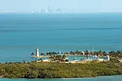 Boca Chita Key Historic District |
August 1, 1997 (#97000795) |
Northwestern section of Boca Chita Key, roughly bounded by Biscayne Bay and a stone wall 25°31′23″N 80°10′29″W |
Biscayne National Park | |
| 2 | Fowey Rocks Light | 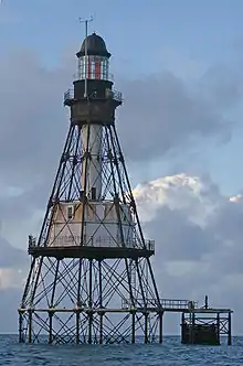 Fowey Rocks Light |
January 26, 2011 (#10001181) |
Offshore in Straits of Florida 6.3 miles south southeast of Cape Florida on Key Biscayne, Florida 25°35′26″N 80°05′48″W |
Key Biscayne | (Light Stations of the United States MPS) |
| 3 | Jones Family Historic District |  Jones Family Historic District |
October 23, 2013 (#13000846) |
Biscayne National Park 25°22′37″N 80°14′29″W |
Islandia vicinity | |
| 4 | Offshore Reefs Archeological District | August 24, 1984 (#84000838) |
Address Restricted |
Homestead | ||
| 5 | Populo |  Populo |
June 15, 2006 (#06000498) |
Biscayne National Park 25°21′51″N 80°09′41″W |
Homestead | Part of the 1733 Spanish Plate Fleet Shipwrecks MPS |
| 6 | Sweeting Homestead | September 19, 1997 (#97001088) |
Address Restricted 25°27′07″N 80°11′28″W |
Biscayne National Park |
See also
| Wikimedia Commons has media related to National Register of Historic Places in Biscayne National Park. |
References
- The latitude and longitude information provided in this table was derived originally from the National Register Information System, which has been found to be fairly accurate for about 99% of listings. Some locations in this table may have been corrected to current GPS standards.
- "National Register of Historic Places: Weekly List Actions". National Park Service, United States Department of the Interior. Retrieved on February 5, 2021.
- Numbers represent an alphabetical ordering by significant words. Various colorings, defined here, differentiate National Historic Landmarks and historic districts from other NRHP buildings, structures, sites or objects.
- The eight-digit number below each date is the number assigned to each location in the National Register Information System database, which can be viewed by clicking the number.
| Topics | |
|---|---|
| Lists by state |
|
| Lists by insular areas | |
| Lists by associated state | |
| Other areas | |
| Related | |
| |
This article is issued from Wikipedia. The text is licensed under Creative Commons - Attribution - Sharealike. Additional terms may apply for the media files.