National Register of Historic Places listings in Buffalo County, Nebraska
This is a list of the National Register of Historic Places listings in Buffalo County, Nebraska.
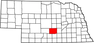
Location of Buffalo County in Nebraska
This is intended to be a complete list of the properties and districts on the National Register of Historic Places in Buffalo County, Nebraska, United States. The locations of National Register properties and districts for which the latitude and longitude coordinates are included below, may be seen in a map.[1]
There are 21 properties and districts listed on the National Register in the county.
- This National Park Service list is complete through NPS recent listings posted January 29, 2021.[2]
Current listings
| [3] | Name on the Register[4] | Image | Date listed[5] | Location | City or town | Description |
|---|---|---|---|---|---|---|
| 1 | John Barnd House | 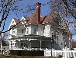 John Barnd House |
March 31, 1983 (#83001079) |
320 E. 31st St. 40°42′23″N 99°04′34″W |
Kearney | Victorian Queen Anne style house built by prominent attorney John Barnd c.1892. The property includes a frame carriage barn which is presently used as a garage.[6] |
| 2 | John J. and Lenora Bartlett House | _2.jpg.webp) John J. and Lenora Bartlett House |
December 27, 2007 (#07001321) |
1402 9th Ave. 40°41′19″N 99°05′39″W |
Kearney | |
| 3 | Fort Theater | 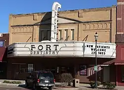 Fort Theater |
July 12, 2006 (#06000607) |
2205 Central Ave. 40°41′52″N 99°04′52″W |
Kearney | |
| 4 | George W. Frank House | _from_NE_2.JPG.webp) George W. Frank House |
February 23, 1973 (#73001054) |
University of Nebraska at Kearney 40°42′03″N 99°06′30″W |
Kearney | Richardsonian Romanesque style mansion made with Colorado red sandstone from Wyoming. Built in 1889 by George W. Frank [7] |
| 5 | Gibbon Baptist Church | 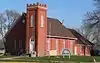 Gibbon Baptist Church |
March 21, 2016 (#15000897) |
917 2nd St. 40°44′48″N 98°50′44″W |
Gibbon | |
| 6 | Hanson-Downing House | _from_SE_1.JPG.webp) Hanson-Downing House |
December 10, 1980 (#80002440) |
723 W. 22nd St. 40°41′53″N 99°05′32″W |
Kearney | |
| 7 | Harmon Park | 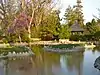 Harmon Park |
December 10, 2010 (#10001002) |
Roughly bounded by 29th and 33rd Sts. and 5th and 7th Aves. 40°42′24″N 99°05′23″W |
Kearney | |
| 8 | Kearney Downtown Historic District | 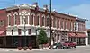 Kearney Downtown Historic District |
November 9, 2017 (#100001797) |
Multiple 40°41′52″N 99°04′54″W |
Kearney | |
| 9 | Kearney Junior High School | Kearney Junior High School |
July 5, 2000 (#00000766) |
300 W. 24th St. 40°41′57″N 99°05′09″W |
Kearney | |
| 10 | Kearney National Guard Armory | Kearney National Guard Armory |
July 16, 2009 (#09000525) |
1600 Central Ave. 40°41′25″N 99°04′55″W |
Kearney | |
| 11 | Kilgore Bridge | 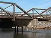 Kilgore Bridge |
June 29, 1992 (#92000768) |
Nebraska Highway 10 over the North Channel Platte River, 7.1 miles southeast of Kearney 40°41′02″N 98°57′03″W |
Kearney | |
| 12 | Klehm House | 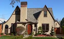 Klehm House |
March 25, 1999 (#99000388) |
2215 9th Ave. 40°41′54″N 99°05′39″W |
Kearney | |
| 13 | Lowe and Fair Commercial Block | 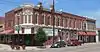 Lowe and Fair Commercial Block |
June 3, 2015 (#14001012) |
2001-2003 Central Ave., 10-12 E. Railroad St. 40°41′44″N 99°04′53″W |
Kearney | |
| 14 | Masonic Temple and World Theater Building | _from_NE_2.JPG.webp) Masonic Temple and World Theater Building |
November 10, 2009 (#09000903) |
2318 Central Ave. 40°41′56″N 99°04′54″W |
Kearney | |
| 15 | Meisner Bank Building | 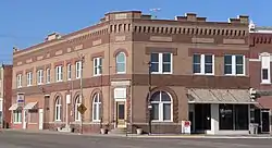 Meisner Bank Building |
March 25, 1999 (#99000390) |
128 C St. 40°46′50″N 98°44′02″W |
Shelton | |
| 16 | George Meisner House | 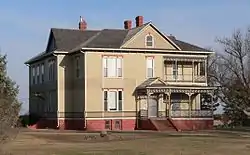 George Meisner House |
June 23, 1988 (#88000903) |
Address Restricted |
Shelton | |
| 17 | Saint Luke's Protestant Episcopal Church | _1.jpg.webp) Saint Luke's Protestant Episcopal Church |
December 1, 1986 (#86003360) |
2304 2nd Ave. 40°42′20″N 99°05′35″W |
Kearney | |
| 18 | Sweetwater Archeological Site | _(4).JPG.webp) Sweetwater Archeological Site |
July 29, 1974 (#74001141) |
SW 1/4, section 35, township 13N, range 15W[8] 41°02′53″N 99°00′58″W |
Sweetwater | |
| 19 | Sweetwater Mill Bridge | Sweetwater Mill Bridge |
June 29, 1992 (#92000767) |
County road over Mud Creek 41°02′27″N 99°00′27″W |
Sweetwater | |
| 20 | Dr. A.O. Thomas House | 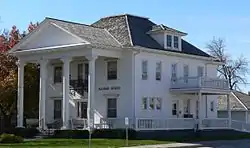 Dr. A.O. Thomas House |
February 28, 1980 (#80002441) |
2222 9th Ave. 40°41′55″N 99°05′39″W |
Kearney | |
| 21 | U.S. Post Office | 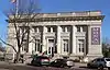 U.S. Post Office |
September 17, 1981 (#81000368) |
2401 Central Ave. 40°41′59″N 99°04′52″W |
Kearney |
See also
References
- The latitude and longitude information provided in this table was derived originally from the National Register Information System, which has been found to be fairly accurate for about 99% of listings. Some locations in this table may have been corrected to current GPS standards.
- "National Register of Historic Places: Weekly List Actions". National Park Service, United States Department of the Interior. Retrieved on January 29, 2021.
- Numbers represent an alphabetical ordering by significant words. Various colorings, defined here, differentiate National Historic Landmarks and historic districts from other NRHP buildings, structures, sites or objects.
- "National Register Information System". National Register of Historic Places. National Park Service. April 24, 2008.
- The eight-digit number below each date is the number assigned to each location in the National Register Information System database, which can be viewed by clicking the number.
- https://npgallery.nps.gov/NRHP/GetAsset/d9c92880-266d-4751-b904-ee5551c4b198/?branding=NRHP
- https://npgallery.nps.gov/NRHP/AssetDetail?assetID=278dbc9f-125e-475f-832b-16c3c63f4c3c
- Champe, John L. (1936). "The Sweetwater Culture Complex". Chapters in Nebraska Archaeology, vol. 1, ed. by Earl H. Bell. pp. 253-57.
External links
| Wikimedia Commons has media related to National Register of Historic Places in Buffalo County, Nebraska. |
- Nebraska National Register Sites in Buffalo County–Nebraska State Historical Society
| Topics | |
|---|---|
| Lists by state |
|
| Lists by insular areas | |
| Lists by associated state | |
| Other areas | |
| Related | |
| |
Municipalities and communities of Buffalo County, Nebraska, United States | ||
|---|---|---|
| Cities | Map of Nebraska highlighting Buffalo County | |
| Villages | ||
| CDPs | ||
| Other unincorporated communities | ||
| Townships | ||
| Footnotes | ‡This populated place also has portions in an adjacent county or counties | |
| ||
This article is issued from Wikipedia. The text is licensed under Creative Commons - Attribution - Sharealike. Additional terms may apply for the media files.