National Register of Historic Places listings in Butte County, South Dakota
This is a list of the National Register of Historic Places listings in Butte County, South Dakota.
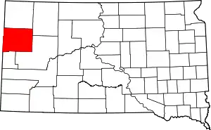
Location of Butte County in South Dakota
This is intended to be a complete list of the properties and districts on the National Register of Historic Places in Butte County, South Dakota, United States. The locations of National Register properties and districts for which the latitude and longitude coordinates are included below, may be seen in a map.[1]
There are 39 properties and districts listed on the National Register in the county. Another 5 properties were once listed but have been removed.
- This National Park Service list is complete through NPS recent listings posted January 29, 2021.[2]
Current listings
| [3] | Name on the Register[4] | Image | Date listed[5] | Location | City or town | Description |
|---|---|---|---|---|---|---|
| 1 | Belle Fourche Band Shell | 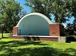 Belle Fourche Band Shell |
December 6, 2016 (#16000823) |
Herrmann Park 44°40′03″N 103°50′56″W |
Belle Fourche | |
| 2 | Belle Fourche Commercial Historic District | 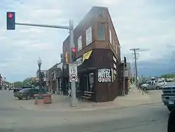 Belle Fourche Commercial Historic District |
April 27, 1982 (#82003917) |
500-620 State St. and 608-622 5th Ave. 44°40′20″N 103°51′12″W |
Belle Fourche | |
| 3 | Belle Fourche Dam | 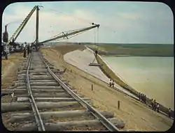 Belle Fourche Dam |
November 23, 1977 (#77001239) |
East of Belle Fourche off U.S. Route 212 44°44′06″N 103°40′28″W |
Belle Fourche | |
| 4 | Belle Fourche Experiment Farm | December 22, 1976 (#76001722) |
Northwest of Newell off Highway 79 44°43′45″N 103°27′01″W |
Newell | ||
| 5 | Charles Bolles House | 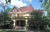 Charles Bolles House |
July 1, 1982 (#82003918) |
919 State St. 44°40′18″N 103°50′44″W |
Belle Fourche | |
| 6 | Butte County Courthouse and Historic Jail Building | 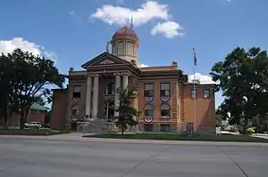 Butte County Courthouse and Historic Jail Building |
December 3, 1998 (#98001398) |
839 5th Ave. 44°40′12″N 103°48′54″W |
Belle Fourche | |
| 7 | Butte-Lawrence County Fairgrounds | April 30, 1986 (#86000934) |
Southwest of Nisland 44°40′02″N 103°34′04″W |
Nisland | ||
| 8 | Chambers Dugout | March 11, 2019 (#100003437) |
19003 Rimrock Ranch 44°38′54″N 104°00′59″W |
Belle Fourche vicinity | ||
| 9 | Ditchrider House | January 31, 2002 (#01000172) |
North of U.S. Route 212 44°40′46″N 103°33′31″W |
Nisland | ||
| 10 | First Congregational United Church of Christ | 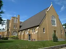 First Congregational United Church of Christ |
July 30, 2013 (#13000571) |
717 Jackson St 44°40′02″N 103°50′59″W |
Belle Fourche | |
| 11 | Fruitdale School | April 30, 1986 (#86000926) |
High St. 44°40′12″N 103°41′36″W |
Fruitdale | ||
| 12 | Fruitdale Store | April 30, 1986 (#86000927) |
Water and Main Sts. 44°40′09″N 103°41′44″W |
Fruitdale | ||
| 13 | Carl Friedrick Gartner Homestead | April 30, 1986 (#86000930) |
West of Highway 79 44°42′29″N 103°29′21″W |
Newell | ||
| 14 | Thomas Haskins Gay House | 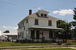 Thomas Haskins Gay House |
July 19, 1982 (#82003919) |
704 Harding 44°40′13″N 103°51′00″W |
Belle Fourche | |
| 15 | Fred S. Harris House | 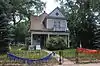 Fred S. Harris House |
July 13, 1988 (#88000575) |
826 State St. 44°40′17″N 103°50′51″W |
Belle Fourche | |
| 16 | Hay Creek Bridge | December 9, 1993 (#93001274) |
8th Ave. over Hay Creek 44°39′54″N 103°51′05″W |
Belle Fourche | ||
| 17 | Hoover Store | 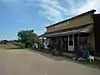 Hoover Store |
April 30, 1986 (#86000931) |
Highway 79 45°06′45″N 103°16′16″W |
Hoover | |
| 18 | Alexander Hoover House | April 30, 1986 (#86000929) |
Highway 59 45°06′46″N 103°16′06″W |
Hoover | ||
| 19 | William Johnson House | April 30, 1986 (#86000928) |
High St. 44°40′14″N 103°41′38″W |
Fruitdale | ||
| 20 | William G. Kenaston House | February 23, 1984 (#84003246) |
301 Dartmouth 44°42′54″N 103°25′31″W |
Newell | ||
| 21 | Langdon School | April 30, 1986 (#86000935) |
Snoma Rd. 44°38′59″N 103°28′45″W |
Nisland | ||
| 22 | Lincoln School | 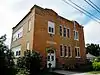 Lincoln School |
February 9, 2001 (#01000098) |
706 Jackson 44°40′00″N 103°51′00″W |
Belle Fourche | |
| 23 | Minnesela Bridge | December 9, 1993 (#93001277) |
Local road over Redwater Creek 44°38′28″N 103°49′19″W |
Belle Fourche | ||
| 24 | Newell Depot Bridge | August 5, 1999 (#99000953) |
Local road over Horse Creek 44°42′20″N 103°29′10″W |
Newell | ||
| 25 | Newell High School | May 1, 1986 (#86000947) |
Dartmouth St. 44°43′04″N 103°25′34″W |
Newell | ||
| 26 | Roosevelt School | 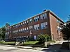 Roosevelt School |
March 14, 2019 (#100003438) |
1010 State St. 44°40′17″N 103°50′42″W |
Belle Fourche | |
| 27 | John Aaron Scotney House | 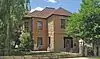 John Aaron Scotney House |
January 3, 1978 (#78002541) |
830 9th St. 44°40′09″N 103°50′55″W |
Belle Fourche | |
| 28 | Charles and Eleanor Small House | 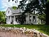 Charles and Eleanor Small House |
November 1, 1991 (#91001617) |
825 5th Ave. 44°40′09″N 103°51′10″W |
Belle Fourche | |
| 29 | Snoma Finnish Cemetery | November 13, 1985 (#85003492) |
3.5 miles southeast of Fruitdale 44°37′59″N 103°41′06″W |
Fruitdale | ||
| 30 | Soper-Behymer Ranch | June 6, 1986 (#86001262) |
Highway 34 Coordinates missing |
Belle Fourche | ||
| 31 | South Dakota Dept. of Transportation Bridge No. 10-109-360 | December 9, 1993 (#93001275) |
Local road over the Diversion Dam Inlet Canal in the Belle Fourche Irrigation District 44°41′27″N 103°49′52″W |
Belle Fourche | ||
| 32 | South Dakota Dept. of Transportation Bridge No. 10-270-338 | February 18, 2000 (#00000124) |
Local road over Horse Creek 44°43′21″N 103°30′22″W |
Newell | Replaced in 2002 | |
| 33 | Stonelake Bridge | April 30, 1986 (#86000932) |
Winkler Rd. 44°43′21″N 103°30′24″W |
Newell | ||
| 34 | Tri State Bakery | 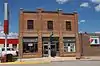 Tri State Bakery |
August 5, 1993 (#93000781) |
705 State St. 44°40′18″N 103°50′58″W |
Belle Fourche | |
| 35 | Vale Bridge | August 5, 1999 (#99000954) |
Local road over the Belle Fourche River 44°37′45″N 103°23′13″W |
Vale | ||
| 36 | Vale Cut Off Belle Fourche River Bridge | April 30, 1986 (#86000937) |
7 miles southwest of Newell 44°40′17″N 103°29′32″W |
Belle Fourche | ||
| 37 | Vale School | August 1, 1984 (#84003250) |
Off Highway 79 44°37′14″N 103°23′53″W |
Vale | ||
| 38 | Nicholas Augustus Viken Homestead | April 30, 1986 (#86000933) |
North of Hope Cemetery Rd. 44°42′51″N 103°28′35″W |
Newell | ||
| 39 | Wide Awake Grocery Building | 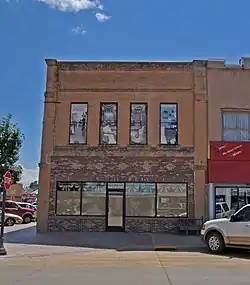 Wide Awake Grocery Building |
March 30, 1978 (#78002542) |
520 State St. 44°40′15″N 103°51′02″W |
Belle Fourche |
Former listings
| [3] | Name on the Register | Image | Date listed | Date removed | Location | City or town | Summary |
|---|---|---|---|---|---|---|---|
| 1 | Belle Fourche River Bridge | April 30, 1986 (#86000923) | August 1, 1996 | NE of Belle Fourche of US 212 |
Belle Fourche vicinity | Rural Butte and Meade Counties MRA | |
| 2 | Fruitdale Bridge | April 30, 1986 (#86000925) | August 1, 1996 | 1/2 Mi S of Fruitdale |
Fruitdale vicinity | Rural Butte and Meade Counties MRA | |
| 3 | Nisland Bridge | April 30, 1986 (#86000936) | March 26, 2008 | S of Nisland on Section Rd. |
Nisland | ||
| 4 | Olson Bridge | April 30, 1986 (#86000924) | March 26, 2008 | NE of Belle Fourche |
Belle Fourche | ||
| 5 | South Dakota Dept. of Transportation Bridge No. 10-112-355 | December 9, 1993 (#93001276) | December 15, 1999 | Diversion Dam Rd. over Crow Cr. |
Belle Fourche vicinity |
See also
| Wikimedia Commons has media related to National Register of Historic Places in Butte County, South Dakota. |
References
- The latitude and longitude information provided in this table was derived originally from the National Register Information System, which has been found to be fairly accurate for about 99% of listings. Some locations in this table may have been corrected to current GPS standards.
- "National Register of Historic Places: Weekly List Actions". National Park Service, United States Department of the Interior. Retrieved on January 29, 2021.
- Numbers represent an alphabetical ordering by significant words. Various colorings, defined here, differentiate National Historic Landmarks and historic districts from other NRHP buildings, structures, sites or objects.
- "National Register Information System". National Register of Historic Places. National Park Service. April 24, 2008.
- The eight-digit number below each date is the number assigned to each location in the National Register Information System database, which can be viewed by clicking the number.
| Topics | |
|---|---|
| Lists by state |
|
| Lists by insular areas | |
| Lists by associated state | |
| Other areas | |
| Related | |
| |
Municipalities and communities of Butte County, South Dakota, United States | ||
|---|---|---|
| Cities | | |
| Towns | ||
| Townships | ||
| Unorganized territories |
| |
| CDP | ||
| Other unincorporated communities | ||
| Ghost town | ||
| ||
This article is issued from Wikipedia. The text is licensed under Creative Commons - Attribution - Sharealike. Additional terms may apply for the media files.