National Register of Historic Places listings in Calaveras County, California
This is a list of the National Register of Historic Places listings in Calaveras County, California.
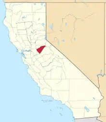
Location of Calaveras County in California
This is intended to be a complete list of the properties and districts on the National Register of Historic Places in Calaveras County, California, United States. Latitude and longitude coordinates are provided for many National Register properties and districts; these locations may be seen together in a Google map.[1]
There are 16 properties and districts listed on the National Register in the county.
- This National Park Service list is complete through NPS recent listings posted January 29, 2021.[2]
Current listings
| [3] | Name on the Register[4] | Image | Date listed[5] | Location | City or town | Description |
|---|---|---|---|---|---|---|
| 1 | Altaville Grammar School | 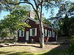 Altaville Grammar School |
August 24, 1979 (#79000471) |
125 N. Main St. 38°04′58″N 120°33′39″W |
Altaville | |
| 2 | Angels Hotel | 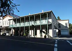 Angels Hotel |
March 24, 1972 (#72000220) |
Main St. at Birds Way 38°04′08″N 120°32′44″W |
Angels Camp | |
| 3 | Calaveras County Bank |  Calaveras County Bank |
August 1, 1985 (#85001683) |
1239 Main St. 38°04′11″N 120°32′22″W |
Angels Camp | |
| 4 | Calaveras County Courthouse | 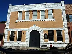 Calaveras County Courthouse |
February 28, 1972 (#72000221) |
Main St. 38°11′48″N 120°40′45″W |
San Andreas | |
| 5 | Calaveritas Creek Bridge | November 6, 2015 (#15000767) |
Calaveritas Rd. at Calaveritas Cr. 38°09′22″N 120°36′35″W |
Calaveritas | ||
| 6 | Sam Choy Brick Store |  Sam Choy Brick Store |
September 20, 1984 (#84000759) |
Bird Way 38°04′09″N 120°32′18″W |
Angels Camp | |
| 7 | Copperopolis Armory | 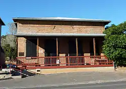 Copperopolis Armory |
December 30, 1997 (#97001588) |
695 Main St. 37°58′34″N 120°38′04″W |
Copperopolis | |
| 8 | Copperopolis Congregational Church | 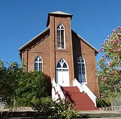 Copperopolis Congregational Church |
December 30, 1997 (#97001587) |
411 Main St. 37°58′47″N 120°38′16″W |
Copperopolis | |
| 9 | Douglas Flat School | 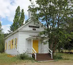 Douglas Flat School |
May 24, 1973 (#73000397) |
NE of Vallecito on SR 4 38°07′01″N 120°27′11″W |
Douglas Flat | |
| 10 | Honigsberger Store | 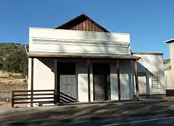 Honigsberger Store |
April 2, 1992 (#92000310) |
665 Main St. 37°58′34″N 120°38′07″W |
Copperopolis | |
| 11 | Murphys Grammar School | 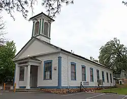 Murphys Grammar School |
June 8, 1973 (#73000398) |
Jones St. 38°08′08″N 120°27′24″W |
Murphys | |
| 12 | Murphys Hotel | 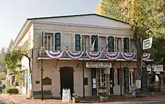 Murphys Hotel |
November 23, 1971 (#71000134) |
Main and Algiers Sts. 38°08′15″N 120°27′50″W |
Murphys | Also known as Mitchler Hotel |
| 13 | Reed's Store | 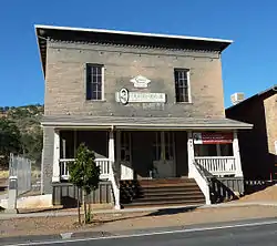 Reed's Store |
April 2, 1992 (#92000309) |
679 Main St. 37°58′34″N 120°38′05″W |
Copperopolis | |
| 14 | John J. Snyder House |  John J. Snyder House |
August 2, 1984 (#84000760) |
247 W. St. Charles St. 38°11′51″N 120°41′06″W |
San Andreas | |
| 15 | Thorn House | 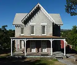 Thorn House |
February 23, 1972 (#72000222) |
87 E. St. Charles St. 38°11′43″N 120°40′40″W |
San Andreas | |
| 16 | Utica Mansion |  Utica Mansion |
May 31, 1984 (#84000764) |
1103 Bush St. 38°04′16″N 120°32′32″W |
Angels Camp |
See also
| Wikimedia Commons has media related to National Register of Historic Places in Calaveras County, California. |
References
- The latitude and longitude information provided in this table was derived originally from the National Register Information System, which has been found to be fairly accurate for about 99% of listings. Some locations in this table may have been corrected to current GPS standards.
- "National Register of Historic Places: Weekly List Actions". National Park Service, United States Department of the Interior. Retrieved on January 29, 2021.
- Numbers represent an alphabetical ordering by significant words. Various colorings, defined here, differentiate National Historic Landmarks and historic districts from other NRHP buildings, structures, sites or objects.
- "National Register Information System". National Register of Historic Places. National Park Service. July 9, 2010.
- The eight-digit number below each date is the number assigned to each location in the National Register Information System database, which can be viewed by clicking the number.
| Topics | |
|---|---|
| Lists by state |
|
| Lists by insular areas | |
| Lists by associated state | |
| Other areas | |
| Related | |
| |
Municipalities and communities of Calaveras County, California, United States | ||
|---|---|---|
| City | Calaveras County map | |
| CDPs | ||
| Unincorporated communities |
| |
| Former settlements | ||
| ||
This article is issued from Wikipedia. The text is licensed under Creative Commons - Attribution - Sharealike. Additional terms may apply for the media files.