National Register of Historic Places listings in Capitol Reef National Park
This is a list of the National Register of Historic Places listings in Capitol Reef National Park.
This is intended to be a complete list of the properties and districts on the National Register of Historic Places in Capitol Reef National Park, Utah, United States. The locations of National Register properties and districts for which the latitude and longitude coordinates are included below, may be seen in a Google map.[1]
There are ten properties and districts listed on the National Register in the park.
- This National Park Service list is complete through NPS recent listings posted January 29, 2021.[2]
Current listings
| [3] | Name on the Register | Image | Date listed[4] | Location | City or town | Description |
|---|---|---|---|---|---|---|
| 1 | Elijah Cutler Behunin Cabin | 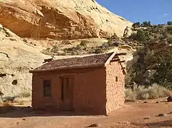 Elijah Cutler Behunin Cabin |
September 13, 1999 (#99001094) |
State Route 24, 1.5 miles southeast of the tip of Horse Mesa 38°16′56″N 111°10′12″W |
Torrey | |
| 2 | Cathedral Valley Corral | 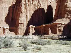 Cathedral Valley Corral |
September 13, 1999 (#99001093) |
Middle Desert, southeast of the confluence of Cathedral Mountain and Cathedral Valley 38°29′05″N 111°20′58″W |
Torrey | |
| 3 | Civilian Conservation Corps Powder Magazine | 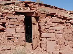 Civilian Conservation Corps Powder Magazine |
September 13, 1999 (#99001090) |
South of the Fremont River, north of Cuts Canyon 38°16′33″N 111°15′04″W |
Torrey | |
| 4 | Fruita Rural Historic District | 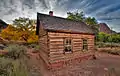 Fruita Rural Historic District |
March 25, 1997 (#97000246) |
Roughly along State Route 24 from Sulphur Creek to Hickman Natural Bridge 38°17′06″N 111°15′07″W |
Fruita | |
| 5 | Fruita Schoolhouse | 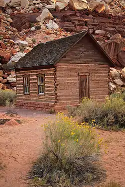 Fruita Schoolhouse |
February 23, 1972 (#72000098) |
Capitol Reef National Park on State Route 24 38°17′15″N 111°14′45″W |
Fruita | |
| 6 | Hanks' Dugouts | 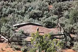 Hanks' Dugouts |
September 13, 1999 (#99001095) |
Confluence of Pleasant Creek and South Draw 38°10′39″N 111°11′03″W |
Torrey | |
| 7 | Lesley Morrell Line Cabin and Corral | 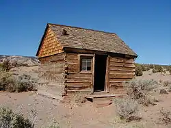 Lesley Morrell Line Cabin and Corral |
September 13, 1999 (#99001096) |
Confluence of Middle Desert Wash and Cathedral Valley 38°29′02″N 111°21′55″W |
Torrey | |
| 8 | Oak Creek Dam | September 13, 1999 (#99001091) |
Oak Creek, north of North Coleman Canyon 38°05′00″N 111°08′15″W |
Torrey | ||
| 9 | Oyler Mine | 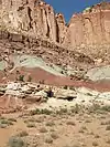 Oyler Mine |
September 14, 1999 (#99001092) |
Confluence of Grand Wash and Cohab Canyon 38°15′33″N 111°13′51″W |
Torrey | |
| 10 | Pioneer Register | 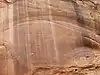 Pioneer Register |
September 13, 1999 (#99001097) |
Southwest of the confluence of Capitol Wash and Waterpocket Canyon 38°12′41″N 111°09′36″W |
Torrey |
See also
References
- Brower, Benjamin; McKoy, Kathy. National Register of Historic Places Multiple Property Documentation Form: Capitol Reef National Park Multiple Property Documentation Form. National Park Service March 15, 1996 https://npgallery.nps.gov/NRHP/GetAsset/NRHP/64500662_text
- The latitude and longitude information provided in this table was derived originally from the National Register Information System, which has been found to be fairly accurate for about 99% of listings. Some locations in this table may have been corrected to current GPS standards.
- "National Register of Historic Places: Weekly List Actions". National Park Service, United States Department of the Interior. Retrieved on January 29, 2021.
- Numbers represent an alphabetical ordering by significant words. Various colorings, defined here, differentiate National Historic Landmarks and historic districts from other NRHP buildings, structures, sites or objects.
- The eight-digit number below each date is the number assigned to each location in the National Register Information System database, which can be viewed by clicking the number.
| Topics | |
|---|---|
| Lists by state |
|
| Lists by insular areas | |
| Lists by associated state | |
| Other areas | |
| Related | |
| |
| Wikimedia Commons has media related to National Register of Historic Places in Capitol Reef National Park. |
This article is issued from Wikipedia. The text is licensed under Creative Commons - Attribution - Sharealike. Additional terms may apply for the media files.