National Register of Historic Places listings in Cheyenne County, Nebraska
This is a list of the National Register of Historic Places listings in Cheyenne County, Nebraska. It is intended to be a complete list of the properties and districts on the National Register of Historic Places in Cheyenne County, Nebraska, United States. The locations of National Register properties and districts for which the latitude and longitude coordinates are included below, may be seen in a map.[1]
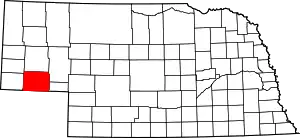
Location of Cheyenne County in Nebraska
There are 11 properties and districts listed on the National Register in the county.
- This National Park Service list is complete through NPS recent listings posted January 29, 2021.[2]
Listings county-wide
| [3] | Name on the Register | Image | Date listed[4] | Location | City or town | Description |
|---|---|---|---|---|---|---|
| 1 | Christ Episcopal Church | 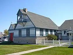 Christ Episcopal Church |
October 21, 1994 (#94001232) |
Junction of 10th Ave. and Linden St. 41°08′30″N 102°58′32″W |
Sidney | |
| 2 | Deadwood Draw | 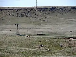 Deadwood Draw |
November 12, 1992 (#92001574) |
Northwest of Sidney 41°09′35″N 103°00′28″W |
Sidney | |
| 3 | Fort Sidney Historic District | 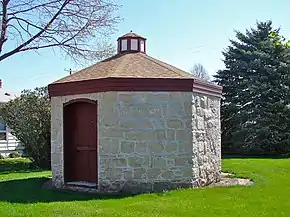 Fort Sidney Historic District |
March 28, 1973 (#73001056) |
Roughly bounded by 6th and 5th Aves., Linden and Jackson 41°08′35″N 102°58′10″W |
Sidney | |
| 4 | Daniel and Sarah Herboldsheimer Ranch | Daniel and Sarah Herboldsheimer Ranch |
April 5, 1990 (#90000566) |
Northeast of Potter 41°16′44″N 103°13′26″W |
Potter | |
| 5 | Lodgepole Opera House | 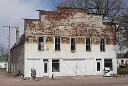 Lodgepole Opera House |
July 7, 1988 (#88000947) |
Western side of Oberfelder at Front 41°08′52″N 102°38′22″W |
Lodgepole | |
| 6 | Sidney Carnegie Library | 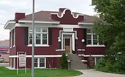 Sidney Carnegie Library |
July 3, 1991 (#91000838) |
740 Illinois St. 41°08′43″N 102°58′26″W |
Sidney | |
| 7 | Sidney Historic Business District | 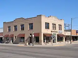 Sidney Historic Business District |
October 21, 1994 (#94001233) |
Roughly bounded by Hickory and King Sts. and 9th and 11th Aves.; also roughly bounded by Hickory and King Sts. and 9th and 12th Aves. 41°08′40″N 96°58′34″W |
Sidney | Second set of addresses represents a boundary increase |
| 8 | Sioux Ordnance Depot Fire & Guard Headquarters | 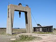 Sioux Ordnance Depot Fire & Guard Headquarters |
October 24, 1994 (#94001234) |
Junction of 1st Ave. and Military Rd. at Western Nebraska Community College 41°12′52″N 103°06′14″W |
Sidney | |
| 9 | Wes Stevens Site | August 28, 1973 (#73001055) |
Address Restricted |
Potter | ||
| 10 | Water Holes Ranch | _ruts.JPG.webp) Water Holes Ranch |
November 12, 1992 (#92001575) |
Roughly 7.5 miles west of Gurley 41°18′23″N 103°06′52″W |
Gurley | |
| 11 | Wild Horse Draw-Leeman's Springs Archeological District | July 12, 2006 (#06000556) |
Address Restricted |
Sidney |
Former listing
| [3] | Name on the Register | Image | Date listed | Date removed | Location | City or town | Summary |
|---|---|---|---|---|---|---|---|
| 1 | Brownson Viaduct | Brownson Viaduct |
June 29, 1992 (#92000747) | December 31, 2013 | Spur 17A over U.S. Route 30 and Union Pacific tracks, 0.8 miles northwest of Brownson 41°11′22″N 103°07′17″W |
Brownson | Demolished in 2000 and replaced by a modern concrete beam bridge: see photo |
See also
References
- The latitude and longitude information provided in this table was derived originally from the National Register Information System, which has been found to be fairly accurate for about 99% of listings. Some locations in this table may have been corrected to current GPS standards.
- "National Register of Historic Places: Weekly List Actions". National Park Service, United States Department of the Interior. Retrieved on January 29, 2021.
- Numbers represent an alphabetical ordering by significant words. Various colorings, defined here, differentiate National Historic Landmarks and historic districts from other NRHP buildings, structures, sites or objects.
- The eight-digit number below each date is the number assigned to each location in the National Register Information System database, which can be viewed by clicking the number.
External links
| Wikimedia Commons has media related to National Register of Historic Places in Cheyenne County, Nebraska. |
- Nebraska National Register Sites in Cheyenne County–Nebraska State Historical Society
| Topics | |
|---|---|
| Lists by state |
|
| Lists by insular areas | |
| Lists by associated state | |
| Other areas | |
| Related | |
| |
This article is issued from Wikipedia. The text is licensed under Creative Commons - Attribution - Sharealike. Additional terms may apply for the media files.