National Register of Historic Places listings in Davison County, South Dakota
This is a list of the National Register of Historic Places listings in Davison County, South Dakota.
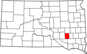
Location of Davison County in South Dakota
This is intended to be a complete list of the properties and districts on the National Register of Historic Places in Davison County, South Dakota, United States. The locations of National Register properties and districts for which the latitude and longitude coordinates are included below, may be seen in a map.[1]
There are 25 properties and districts listed on the National Register in the county, including 1 National Historic Landmark.
- This National Park Service list is complete through NPS recent listings posted February 5, 2021.[2]
Current listings
| [3] | Name on the Register[4] | Image | Date listed[5] | Location | City or town | Description |
|---|---|---|---|---|---|---|
| 1 | John F. Anderson House |  John F. Anderson House |
July 1, 1982 (#82003925) |
323 N. Duff 43°42′39″N 98°01′45″W |
Mitchell | |
| 2 | Whittier and Virginia Bauer House |  Whittier and Virginia Bauer House |
March 1, 2010 (#10000048) |
600 E. 4th Ave. 43°42′45″N 98°01′07″W |
Mitchell | |
| 3 | Louis Beckwith House |  Louis Beckwith House |
July 1, 1982 (#82003926) |
1311 S. Duff Dr. 43°41′51″N 98°01′42″W |
Mitchell | |
| 4 | E. B. Bobb House |  E. B. Bobb House |
October 31, 2002 (#02001282) |
501 E. 4th St. 43°42′45″N 98°01′12″W |
Mitchell | |
| 5 | C. E. Chambers House |  C. E. Chambers House |
January 26, 1990 (#89002334) |
322 W. 11th St. 43°43′11″N 98°01′45″W |
Mitchell | |
| 6 | Dakota Wesleyan University |  Dakota Wesleyan University |
December 22, 1976 (#76001727) |
Bounded by E. and W. University Aves. and McCabe St. 43°41′55″N 98°01′51″W |
Mitchell | |
| 7 | Ellis and Roberta Henline Farmstead | November 29, 2010 (#10000950) |
39987 252nd St. 43°43′54″N 98°12′32″W |
Mount Vernon vicinity | ||
| 8 | W. S. Hill House |  W. S. Hill House |
June 19, 2009 (#09000445) |
520 East 6th Avenue 43°42′52″N 98°01′11″W |
Mitchell | |
| 9 | Holy Family Church, School, and Rectory | 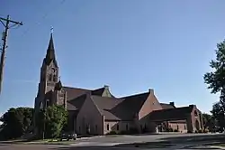 Holy Family Church, School, and Rectory |
December 12, 1976 (#76001729) |
Kimball and Davison Sts., E. 2nd and E. 3rd Aves. 43°42′40″N 98°01′18″W |
Mitchell | |
| 10 | Kibbee-Nepstad House |  Kibbee-Nepstad House |
September 22, 1995 (#95001122) |
409 E. 5th Ave. 43°42′49″N 98°01′19″W |
Mitchell | |
| 11 | Koch Apartments | 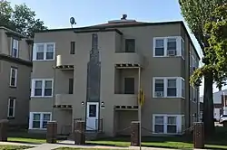 Koch Apartments |
October 31, 1996 (#94000562) |
209 W. 2nd Ave. 43°42′39″N 98°01′38″W |
Mitchell | |
| 12 | William Koch House |  William Koch House |
October 31, 1996 (#94000566) |
201 W. 2nd St. 43°42′39″N 98°01′36″W |
Mitchell | |
| 13 | Mitchell Historic Commercial District | 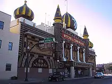 Mitchell Historic Commercial District |
June 27, 1975 (#75001716) |
210 S.-604 N. Main, 119-201 W. 3rd St., 117-219 E. 4th St., and 112-220 W. 5th St.; also roughly bounded by Duff, Railroad and Lawler Sts. 43°42′39″N 98°01′29″W |
Mitchell | Second set of boundaries represents a boundary increase |
| 14 | Mitchell Lustron Historic District |  Mitchell Lustron Historic District |
December 2, 1998 (#98001402) |
Roughly along Vincent Place, from Miller Ave. to Mitchell Boulevard 43°41′55″N 98°02′21″W |
Mitchell | |
| 15 | Mitchell Site | 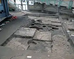 Mitchell Site |
October 15, 1966 (#66000712) |
3200 Indian Village Road 43°44′30″N 98°02′02″W |
Mitchell | An archaeological site of a prehistoric Mississippian culture village. Open to the public. |
| 16 | Mitchell West Central Residential Historic District | 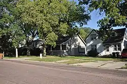 Mitchell West Central Residential Historic District |
June 16, 1999 (#99000676) |
Roughly bounded by 1st and 7th Aves. 43°42′46″N 98°01′40″W |
Mitchell | |
| 17 | Gottlieb and Friederike Scheurenbrand House | 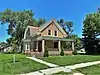 Gottlieb and Friederike Scheurenbrand House |
February 16, 2018 (#100002101) |
700 E Hanson St. 43°42′31″N 98°01′01″W |
Mitchell | |
| 18 | Louis N. and Helen Seaman House | 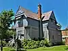 Louis N. and Helen Seaman House |
February 16, 2018 (#100002100) |
300 E 3rd St. 43°42′41″N 98°01′21″W |
Mitchell | |
| 19 | Site 39DV24 | January 31, 1984 (#84003260) |
Address Restricted |
Mitchell | ||
| 20 | Site 39DV9 | January 31, 1984 (#84003275) |
Address Restricted |
Riverside | ||
| 21 | South Dakota Dept. of Transportation Bridge No. 18-040-137 | December 9, 1993 (#93001282) |
Local road over Enemy Creek 43°38′52″N 98°14′45″W |
Mitchell | ||
| 22 | South Dakota Dept. of Transportation Bridge No. 18-060-202 | December 9, 1993 (#93001283) |
Local road over Twelve Mile Creek 43°45′48″N 98°04′13″W |
Mitchell | Relocated in 2010. | |
| 23 | South Dakota Dept. of Transportation Bridge No. 18-100-052 | December 9, 1993 (#93001284) |
Local road over Firesteel Creek 43°46′16″N 98°07′34″W |
Loomis | ||
| 24 | L.J. Welch House |  L.J. Welch House |
October 19, 1989 (#89001722) |
608 E. 4th Ave. 43°42′45″N 98°01′02″W |
Mitchell | |
| 25 | Whittier School | 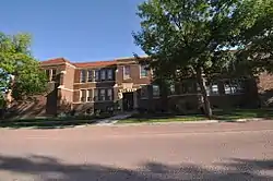 Whittier School |
January 25, 2007 (#06001309) |
410 W. 2nd Ave. 43°42′46″N 98°01′49″W |
Mitchell |
Former listings
| [3] | Name on the Register | Image | Date listed | Date removed | Location | City or town | Summary |
|---|---|---|---|---|---|---|---|
| 1 | South Dakota Dept. of Transportation Bridge No. 18-142-150 | December 9, 1993 (#93001285) | December 15, 1999 | Local rd. over Enemy Cr. |
Mitchell vicinity |
See also
| Wikimedia Commons has media related to National Register of Historic Places in Davison County, South Dakota. |
References
- The latitude and longitude information provided in this table was derived originally from the National Register Information System, which has been found to be fairly accurate for about 99% of listings. Some locations in this table may have been corrected to current GPS standards.
- "National Register of Historic Places: Weekly List Actions". National Park Service, United States Department of the Interior. Retrieved on February 5, 2021.
- Numbers represent an alphabetical ordering by significant words. Various colorings, defined here, differentiate National Historic Landmarks and historic districts from other NRHP buildings, structures, sites or objects.
- "National Register Information System". National Register of Historic Places. National Park Service. April 24, 2008.
- The eight-digit number below each date is the number assigned to each location in the National Register Information System database, which can be viewed by clicking the number.
| Topics | |
|---|---|
| Lists by state |
|
| Lists by insular areas | |
| Lists by associated state | |
| Other areas | |
| Related | |
| |
Municipalities and communities of Davison County, South Dakota, United States | ||
|---|---|---|
| City | | |
| Town | ||
| CDP | ||
| ||
This article is issued from Wikipedia. The text is licensed under Creative Commons - Attribution - Sharealike. Additional terms may apply for the media files.