National Register of Historic Places listings in Hamlin County, South Dakota
This is a list of the National Register of Historic Places listings in Hamlin County, South Dakota.
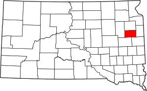
Location of Hamlin County in South Dakota
This is intended to be a complete list of the properties on the National Register of Historic Places in Hamlin County, South Dakota, United States. The locations of National Register properties for which the latitude and longitude coordinates are included below, may be seen in a map.[1]
There are 15 properties listed on the National Register in the county.
- This National Park Service list is complete through NPS recent listings posted January 29, 2021.[2]
Current listings
| [3] | Name on the Register[4] | Image | Date listed[5] | Location | City or town | Description |
|---|---|---|---|---|---|---|
| 1 | Bryant Masonic Lodge 118 | March 26, 2020 (#100005110) |
204 East Main St. 44°35′26″N 97°27′47″W |
Bryant | ||
| 2 | Estelline Bandstand and Gazebo Park | November 30, 1999 (#99001434) |
105 N. Main 44°34′22″N 96°54′09″W |
Estelline | ||
| 3 | First National Bank of Norden | 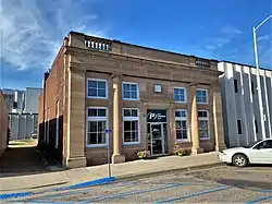 First National Bank of Norden |
October 26, 2005 (#05001189) |
503 Main Ave. 44°34′56″N 97°12′37″W |
Lake Norden | |
| 4 | First State Bank of Hazel | February 21, 1997 (#97000147) |
Main St. west of its junction with Highway 22 44°45′33″N 97°22′55″W |
Hazel | ||
| 5 | Garfield Church and Cemetery | February 15, 2012 (#12000036) |
Northwest corner of SD 28 & 443rd Ave. 44°35′16″N 97°21′05″W |
Bryant vicinity | ||
| 6 | Hamlin County Courthouse | 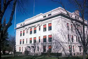 Hamlin County Courthouse |
October 12, 2000 (#00001225) |
300 4th St. 44°39′25″N 97°12′13″W |
Hayti | |
| 7 | M. O. Hanson Building | 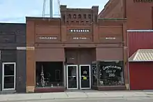 M. O. Hanson Building |
July 28, 2011 (#11000486) |
126 E. Main St. 44°43′19″N 97°02′09″W |
Castlewood | |
| 8 | Hendrick and Waldur Hendrickson Farm | November 13, 1985 (#85003485) |
Highway 28 44°35′06″N 97°15′26″W |
Lake Norden | ||
| 9 | Hoffelt Drug Store | 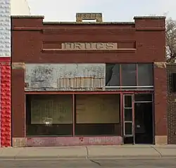 Hoffelt Drug Store |
February 19, 2008 (#08000050) |
212 Main St. 44°34′35″N 96°54′08″W |
Estelline | |
| 10 | Kant Hotel | October 31, 1985 (#85003449) |
North of Highway 28 44°35′26″N 97°28′04″W |
Bryant | ||
| 11 | Charles and Mary Lohr House | July 19, 1982 (#82003927) |
1705 State Ave. 44°34′23″N 96°53′37″W |
Estelline | ||
| 12 | Old St. Mary's Catholic Parish House | December 27, 1988 (#88002840) |
5th Ave. and Underwood St. 44°35′19″N 97°27′57″W |
Bryant | ||
| 13 | South Dakota Dept. of Transportation Bridge No. 29-221-060 | December 9, 1993 (#93001291) |
Local road over the Big Sioux River 44°42′59″N 97°02′41″W |
Castlewood | Replaced | |
| 14 | South Dakota Dept. of Transportation Bridge No. 29-279-010 | December 9, 1993 (#93001292) |
Local road over Stray Horse Creek 44°47′24″N 96°55′35″W |
Castlewood | ||
| 15 | Jacob and Amelia Tuohino Farm | November 13, 1985 (#85003495) |
South of Highway 28 44°34′29″N 97°18′39″W |
Lake Norden |
See also
| Wikimedia Commons has media related to National Register of Historic Places in Hamlin County, South Dakota. |
References
- The latitude and longitude information provided in this table was derived originally from the National Register Information System, which has been found to be fairly accurate for about 99% of listings. Some locations in this table may have been corrected to current GPS standards.
- "National Register of Historic Places: Weekly List Actions". National Park Service, United States Department of the Interior. Retrieved on January 29, 2021.
- Numbers represent an alphabetical ordering by significant words. Various colorings, defined here, differentiate National Historic Landmarks and historic districts from other NRHP buildings, structures, sites or objects.
- "National Register Information System". National Register of Historic Places. National Park Service. April 24, 2008.
- The eight-digit number below each date is the number assigned to each location in the National Register Information System database, which can be viewed by clicking the number.
| Topics | |
|---|---|
| Lists by state |
|
| Lists by insular areas | |
| Lists by associated state | |
| Other areas | |
| Related | |
| |
Municipalities and communities of Hamlin County, South Dakota, United States | ||
|---|---|---|
| Cities | | |
| Towns | ||
| CDP | ||
| Unincorporated communities | ||
| Footnotes | ‡This populated place also has portions in an adjacent county or counties | |
| ||
This article is issued from Wikipedia. The text is licensed under Creative Commons - Attribution - Sharealike. Additional terms may apply for the media files.