National Register of Historic Places listings in Lancaster County, Nebraska
This is a list of the National Register of Historic Places listings in Lancaster County, Nebraska.
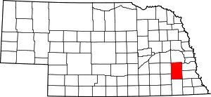
Location of Lancaster County in Nebraska
This is intended to be a complete list of the properties and districts on the National Register of Historic Places in Lancaster County, Nebraska, United States. The locations of National Register properties and districts for which the latitude and longitude coordinates are included below, may be seen in a map.[1]
There are 104 properties and districts listed on the National Register in the county, including 2 National Historic Landmarks. Another 6 properties were once listed but have been removed.
- This National Park Service list is complete through NPS recent listings posted January 29, 2021.[2]
Current listings
| [3] | Name on the Register | Image | Date listed[4] | Location | City or town | Description |
|---|---|---|---|---|---|---|
| 1 | Agricultural Hall | _SW_corner_1.JPG.webp) Agricultural Hall |
December 10, 2010 (#10001001) |
Lincoln's State Fairgrounds 40°49′53″N 96°41′34″W |
Lincoln | |
| 2 | Antelope Grocery | Antelope Grocery |
March 17, 1988 (#88000213) |
2406 J St. 40°48′30″N 96°41′10″W |
Lincoln | |
| 3 | Barr Terrace | _SE_corner.JPG.webp) Barr Terrace |
October 1, 1979 (#79003688) |
627-643 S. 11th, and 1044 H St. 40°48′26″N 96°42′21″W |
Lincoln | Part of the Nineteenth Century Terrace Houses Thematic Resource (TR) |
| 4 | Beatrice Creamery Company Lincoln Plant | _from_SW_1.JPG.webp) Beatrice Creamery Company Lincoln Plant |
March 12, 2012 (#12000104) |
726 L St. 40°48′39″N 96°42′39″W |
Lincoln | |
| 5 | James A. Beattie House | _from_SW_1.JPG.webp) James A. Beattie House |
December 4, 1990 (#90001773) |
6706 Colby St. 40°50′00″N 96°37′43″W |
Lincoln | |
| 6 | Jasper Newton Bell House | _from_S_1.JPG.webp) Jasper Newton Bell House |
June 21, 1984 (#84002483) |
2212 Sheldon St. 40°49′38″N 96°41′22″W |
Lincoln | |
| 7 | Boulevards Historic District | 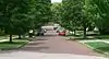 Boulevards Historic District |
December 10, 2008 (#08001180) |
Roughly bounded by South St., Calvert and High Sts., S. 22nd and S. 24th Sts., Rock Island Trail, and Sheridan Boulevard 40°47′04″N 96°41′05″W |
Lincoln | |
| 8 | Guy A. Brown House | 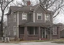 Guy A. Brown House |
March 5, 1998 (#98000195) |
219-221 S. 27th St. 40°48′42″N 96°40′58″W |
Lincoln | |
| 9 | Brownbilt Residential Historic District | 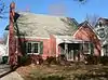 Brownbilt Residential Historic District |
August 29, 2012 (#12000565) |
Bounded by A, D, S. 37th to S. 40th Sts. 40°48′03″N 96°39′56″W |
Lincoln | |
| 10 | Burckhardt House | _from_SW_1.JPG.webp) Burckhardt House |
June 25, 1999 (#99000746) |
1236 Washington St. 40°47′54″N 96°42′11″W |
Lincoln | Part of the African American Historic and Architectural Resources in Lincoln, Nebraska MPS |
| 11 | Edgar A. Burnett House | _from_S_1.JPG.webp) Edgar A. Burnett House |
July 12, 2006 (#06000609) |
3256 Holdrege St. 40°49′42″N 96°40′28″W |
Lincoln | |
| 12 | Burr Block | _from_SW_1.JPG.webp) Burr Block |
May 18, 1979 (#79001448) |
1206 O St. 40°48′50″N 96°42′14″W |
Lincoln | |
| 13 | James D. Calhoun House | _from_SE_2.JPG.webp) James D. Calhoun House |
April 26, 2002 (#02000411) |
1130 Plum St. 40°47′34″N 96°42′17″W |
Lincoln | |
| 14 | William H. Charlton House | 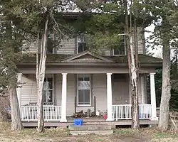 William H. Charlton House |
January 25, 1997 (#96001614) |
17705 S. 12th Street[5] 40°38′13″N 96°42′22″W |
Roca | |
| 15 | Chicago, Burlington & Quincy Steam Locomotive No. 710 | .JPG.webp) Chicago, Burlington & Quincy Steam Locomotive No. 710 |
June 20, 1997 (#97000609) |
Near the junction of 7th and Q Sts. 40°48′57″N 96°42′42″W |
Lincoln | |
| 16 | Christian Record Building | _from_SE_3.JPG.webp) Christian Record Building |
December 1, 1986 (#86003384) |
3705 S. 48th St. 40°46′33″N 96°39′16″W |
Lincoln | |
| 17 | City Hall | _from_NE_1.JPG.webp) City Hall |
October 15, 1969 (#69000132) |
920 O St. 40°48′50″N 96°42′28″W |
Lincoln | |
| 18 | College View Public Library | 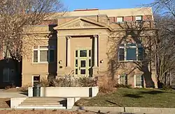 College View Public Library |
June 28, 1984 (#84002486) |
3800 S. 48th St. 40°46′23″N 96°39′13″W |
Lincoln | |
| 19 | Eastridge Historic District | 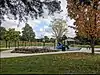 Eastridge Historic District |
July 31, 2017 (#100001394) |
Generally bounded by L to A Sts., 56th & Cotner Blvd. to Sunrise & Mulder Drs. 40°48′19″N 96°38′24″W |
Lincoln | 478 contributing buildings. |
| 20 | Eddy-Taylor House | 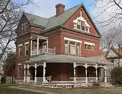 Eddy-Taylor House |
July 21, 1983 (#83001098) |
435 N. 25th 40°49′03″N 96°41′08″W |
Lincoln | |
| 21 | Fairview | _from_S_1.JPG.webp) Fairview |
October 15, 1966 (#66000947) |
4900 Sumner St. 40°47′45″N 96°39′06″W |
Lincoln | |
| 22 | Federal Trust Building | _from_SW_1.JPG.webp) Federal Trust Building |
April 25, 2002 (#02000409) |
134 S. 13th St. 40°48′46″N 96°42′08″W |
Lincoln | |
| 23 | William H. Ferguson House | _from_SW_1.JPG.webp) William H. Ferguson House |
November 29, 1972 (#72000755) |
700 S. 16th St. 40°48′24″N 96°41′52″W |
Lincoln | |
| 24 | First National Bank Building | _from_NW_1.JPG.webp) First National Bank Building |
March 5, 1998 (#98000190) |
1001 O St. 40°48′48″N 96°42′24″W |
Lincoln | |
| 25 | First State Bank of Bethany | 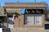 First State Bank of Bethany |
July 24, 1986 (#86001936) |
1551 N. Cotner Boulevard 40°49′44″N 96°37′50″W |
Lincoln | |
| 26 | Frank E. and Emma A. Gillen House | _from_N_1.JPG.webp) Frank E. and Emma A. Gillen House |
March 5, 1998 (#98000188) |
2245 A St. 40°47′55″N 96°41′17″W |
Lincoln | |
| 27 | Gold and Company Store Building | _from_NE_3.JPG.webp) Gold and Company Store Building |
October 19, 1982 (#82000609) |
1033 O St. 40°48′48″N 96°42′21″W |
Lincoln | |
| 28 | Government Square | _from_NE_1.JPG.webp) Government Square |
April 15, 2004 (#04000303) |
N. 9th to N. 10th St., O to P Sts. 40°48′51″N 96°42′28″W |
Lincoln | |
| 29 | Greek Row Historic District | _from_SE_1.JPG.webp) Greek Row Historic District |
June 25, 1997 (#97000611) |
Roughly, R St. from 14th to 17th Sts. and 16th St. from R toVine Sts. 40°49′06″N 96°41′55″W |
Lincoln | |
| 30 | Harris House | _from_S_1.JPG.webp) Harris House |
September 2, 1982 (#82003194) |
1630 K St. 40°48′34″N 96°41′51″W |
Lincoln | |
| 31 | Hayward School | Hayward School |
August 23, 1985 (#85001795) |
1215 N. 9th 40°49′34″N 96°42′31″W |
Lincoln | |
| 32 | Helmer-Winnett-White Flats |  Helmer-Winnett-White Flats |
October 1, 1979 (#79003690) |
1022-1028 K St. 40°48′34″N 96°42′22″W |
Lincoln | Part of the Nineteenth Century Terrace Houses TR |
| 33 | Herter Farmstead |  Herter Farmstead |
July 24, 2000 (#00000835) |
4949 S. 148th[6] 40°45′51″N 96°31′16″W |
Walton | |
| 34 | W.F. Hitchcock House | .JPG.webp) W.F. Hitchcock House |
December 5, 2002 (#02001482) |
2733 Sheridan Boulevard 40°47′11″N 96°40′54″W |
Lincoln | Colonial Revival-styled house built in 1922 |
| 35 | Hotel Capital | _from_NE_2.JPG.webp) Hotel Capital |
December 5, 1983 (#83003994) |
139 N. 11th St. 40°48′52″N 96°42′21″W |
Lincoln | |
| 36 | Aeneas Yates-Charles Hurlbut House | _from_W_1.JPG.webp) Aeneas Yates-Charles Hurlbut House |
September 17, 1999 (#99001167) |
720 S. 16th St. 40°48′22″N 96°41′52″W |
Lincoln | Now occupied by Alpha Delta Pi sorority[7] |
| 37 | Thomas P. Kennard House |  Thomas P. Kennard House |
April 16, 1969 (#69000134) |
1627 H St. 40°48′24″N 96°41′51″W |
Lincoln | |
| 38 | Theodore A. Kiesselbach House | _from_SE_2.JPG.webp) Theodore A. Kiesselbach House |
July 1, 1994 (#94000651) |
3232 Holdrege St. 40°49′42″N 96°40′30″W |
Lincoln | |
| 39 | Rose Kirkwood Brothel | 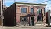 Rose Kirkwood Brothel |
August 28, 2012 (#12000566) |
124 S. 9th St. 40°48′47″N 96°42′29″W |
Lincoln | |
| 40 | Amel H. Koop House | 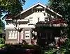 Amel H. Koop House |
December 2, 2014 (#14001014) |
1401 S. 15th St. 40°47′56″N 96°42′00″W |
Lincoln | |
| 41 | Lancaster Block | _from_N_1.JPG.webp) Lancaster Block |
April 12, 1989 (#89000245) |
6201-6205 Havelock Ave. 40°51′25″N 96°38′08″W |
Lincoln | |
| 42 | Lewis-Syford House | _from_W_2.JPG.webp) Lewis-Syford House |
February 18, 1971 (#71000486) |
700 N. 16th St.[8] 40°49′13″N 96°41′52″W |
Lincoln | |
| 43 | Lincoln Army Air Field Regimental Chapel | 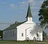 Lincoln Army Air Field Regimental Chapel |
June 17, 1993 (#93000535) |
4601 NW. 48th St. 40°51′38″N 96°47′15″W |
Lincoln | |
| 44 | Lincoln Haymarket Historic District | 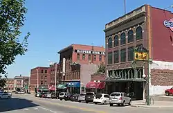 Lincoln Haymarket Historic District |
July 8, 2014 (#14000288) |
Generally 7th to 9th & N to R Sts. 40°48′53″N 96°42′36″W |
Lincoln | (Develop this topic within Haymarket District (Lincoln, Nebraska)) |
| 45 | Lincoln Liberty Life Insurance Building | 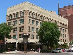 Lincoln Liberty Life Insurance Building |
January 19, 1988 (#87002299) |
113 N. 11th St. 40°48′50″N 96°42′21″W |
Lincoln | |
| 46 | Lincoln Veterans Administration Hospital Historic District | 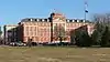 Lincoln Veterans Administration Hospital Historic District |
September 10, 2012 (#12000785) |
600 S. 70th St. 40°48′32″N 96°37′21″W |
Lincoln | Part of the United States Second Generation Veterans Hospitals MPS |
| 47 | Lincoln YWCA Building | _from_SW_1.JPG.webp) Lincoln YWCA Building |
June 21, 1984 (#84002490) |
1432 N St. 40°48′46″N 96°42′01″W |
Lincoln | |
| 48 | Lyman Terrace | Lyman Terrace |
October 1, 1979 (#79003689) |
1111-1119 H St. 40°48′24″N 96°42′18″W |
Lincoln | Part of the Nineteenth Century Terrace Houses TR |
| 49 | Masonic Temple | 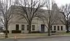 Masonic Temple |
August 5, 2005 (#05000792) |
1635 L St. 40°48′36″N 96°41′50″W |
Lincoln | |
| 50 | McWilliams House | 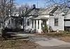 McWilliams House |
June 25, 1999 (#99000748) |
1723 N. 29th St. 40°49′49″N 96°40′48″W |
Lincoln | Part of the African American Historic and Architectural Resources in Lincoln, Nebraska MPS |
| 51 | Mount Emerald and Capitol Additions Historic Residential District |  Mount Emerald and Capitol Additions Historic Residential District |
June 5, 1980 (#80002453) |
Roughly bounded by A, G, 17th, and 22nd Sts. 40°48′08″N 96°41′34″W |
Lincoln | |
| 52 | Municipal Lighting and Waterworks Plant | _from_SW_1.JPG.webp) Municipal Lighting and Waterworks Plant |
July 24, 1986 (#86001938) |
2901 A St. 40°47′55″N 96°40′41″W |
Lincoln | |
| 53 | William L. and Sydney V. Murphy House | 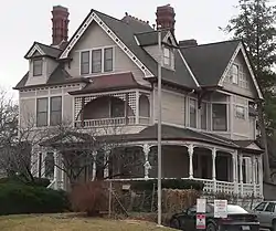 William L. and Sydney V. Murphy House |
November 4, 1994 (#94001280) |
2525 N St. 40°48′44″N 96°41′04″W |
Lincoln | |
| 54 | Nebraska City to Fort Kearny Cutoff Ruts at Spring Creek Prairie | 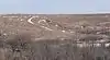 Nebraska City to Fort Kearny Cutoff Ruts at Spring Creek Prairie |
July 11, 2002 (#02000771) |
11700 SW. 100th St. 40°41′30″N 96°50′54″W |
Denton | |
| 55 | Nebraska Governor's Mansion | 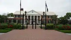 Nebraska Governor's Mansion |
March 12, 2008 (#08000173) |
1425 H St. 40°48′23″N 96°42′02″W |
Lincoln | |
| 56 | Nebraska State Capitol |  Nebraska State Capitol |
October 16, 1970 (#70000372) |
1445 K St. 40°48′29″N 96°41′57″W |
Lincoln | |
| 57 | Nebraska State Historical Society Building | 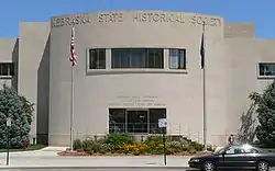 Nebraska State Historical Society Building |
August 21, 2003 (#03000797) |
1500 R St. 40°49′02″N 96°41′59″W |
Lincoln | |
| 58 | Nebraska Telephone Company Building | _from_NW_1.JPG.webp) Nebraska Telephone Company Building |
November 16, 1978 (#78001703) |
128-130 S. 13th St. 40°48′47″N 96°42′09″W |
Lincoln | |
| 59 | Nine-Mile Prairie |  Nine-Mile Prairie |
July 30, 1986 (#86002089) |
Northwest of Huskerville 40°52′01″N 96°48′54″W |
Lincoln | |
| 60 | Old Main, Nebraska Wesleyan University | 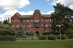 Old Main, Nebraska Wesleyan University |
May 21, 1975 (#75001097) |
50th and St. Paul Sts. 40°50′20″N 96°38′58″W |
Lincoln | |
| 61 | Old University Library | 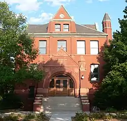 Old University Library |
August 6, 1975 (#75001098) |
11th and R Sts. 40°49′02″N 96°42′22″W |
Lincoln | |
| 62 | Palisade and Regent Apartments | _1035_from_E_1.JPG.webp) Palisade and Regent Apartments |
March 5, 1998 (#98000191) |
1035 S. 17th St. and 1626 D St. 40°48′10″N 96°41′50″W |
Lincoln | |
| 63 | Park Hill | _from_E_1.JPG.webp) Park Hill |
September 3, 2010 (#10000628) |
1913 S. 41st St. 40°47′35″N 96°39′46″W |
Lincoln | |
| 64 | Park Manor Residential Historic District | Park Manor Residential Historic District |
September 4, 2013 (#13000675) |
Bounded by A, South, 56th & 70th Sts. 40°47′44″N 96°38′04″W |
Lincoln | |
| 65 | Peter Peterson Farmstead | 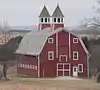 Peter Peterson Farmstead |
February 11, 1980 (#80002456) |
Address Restricted |
Waverly | |
| 66 | Phi Delta Theta Fraternity House | _from_NE_1.JPG.webp) Phi Delta Theta Fraternity House |
May 28, 1986 (#86001183) |
1545 R St. 40°49′00″N 96°41′55″W |
Lincoln | |
| 67 | Phi Kappa Tau Fraternity House |  Phi Kappa Tau Fraternity House |
November 25, 2005 (#05001329) |
5305 Huntington Ave. 40°50′13″N 96°38′48″W |
Lincoln | |
| 68 | R.O. Phillips House | 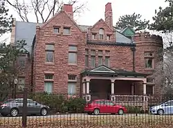 R.O. Phillips House |
November 29, 1979 (#79001449) |
1845 D St 40°48′08″N 96°41′40″W |
Lincoln | |
| 69 | Pioneers Park | _columns_1.JPG.webp) Pioneers Park |
June 17, 1993 (#93000538) |
Junction of W. Van Dorn and Coddington Sts. 40°46′39″N 96°45′57″W |
Lincoln | |
| 70 | President and Ambassador Apartments | 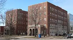 President and Ambassador Apartments |
December 10, 1993 (#93001401) |
1330 and 1340 Lincoln Mall 40°48′30″N 96°42′06″W |
Lincoln | |
| 71 | Quinn Chapel African Methodist Episcopal Church and Parsonage | _from_NW_2.JPG.webp) Quinn Chapel African Methodist Episcopal Church and Parsonage |
June 25, 1999 (#99000749) |
1225 S. 9th St. 40°48′04″N 96°42′32″W |
Lincoln | Part of the African American Historic and Architectural Resources in Lincoln, Nebraska MPS |
| 72 | Retzlaff Farmstead | 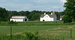 Retzlaff Farmstead |
May 31, 1979 (#79001450) |
Address Restricted |
Lincoln | |
| 73 | Robbers' Cave | March 13, 2020 (#100005055) |
925 Robbers Cave Rd. 40°46′49″N 96°42′27″W |
Lincoln | ||
| 74 | Rock Island Depot | _4.JPG.webp) Rock Island Depot |
September 3, 1971 (#71000487) |
1944 O St. 40°48′51″N 96°41′34″W |
Lincoln | |
| 75 | Nimrod Ross House | 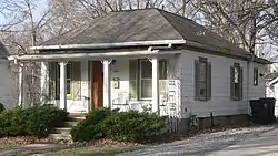 Nimrod Ross House |
June 25, 1999 (#99000747) |
445 S. 30th St. 40°48′28″N 96°40′37″W |
Lincoln | Part of the African American Historic and Architectural Resources in Lincoln, Nebraska MPS |
| 76 | Royer-Williams House |  Royer-Williams House |
June 14, 1982 (#82003195) |
407 N. 26th St. 40°49′02″N 96°41′02″W |
Lincoln | |
| 77 | Ryons-Alexander House | _from_NE_1.JPG.webp) Ryons-Alexander House |
July 8, 1982 (#82003196) |
1835 Ryons St. 40°47′26″N 96°41′41″W |
Lincoln | |
| 78 | St. Charles Apartments | _from_NE_1.JPG.webp) St. Charles Apartments |
September 12, 1985 (#85002138) |
4717 Baldwin Ave. 40°50′17″N 96°39′17″W |
Lincoln | |
| 79 | Schrader Archeological Site | January 21, 1974 (#74002290) |
9 miles (14 km) south of Lincoln[9] |
Roca | Village along Salt Creek named for the landowner. Excavated by E.E. Blackman in 1901;[9] by him denominated the "Roca Site"[10] | |
| 80 | Scottish Rite Temple | Scottish Rite Temple |
December 1, 1986 (#86003359) |
332 Centennial Mall, S. 40°48′38″N 96°41′58″W |
Lincoln | |
| 81 | Sheldon Memorial Art Gallery | _interior_1.JPG.webp) Sheldon Memorial Art Gallery |
September 3, 2013 (#13000676) |
12th & R Sts., University of Nebraska–Lincoln 40°49′03″N 96°42′16″W |
Lincoln | |
| 82 | Sky Park Manor | 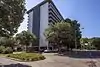 Sky Park Manor |
August 8, 2016 (#16000515) |
1301 Lincoln Mall 40°48′29″N 96°42′08″W |
Lincoln | |
| 83 | South Bottoms Historic District |  South Bottoms Historic District |
July 17, 1986 (#86001717) |
Roughly bounded by M and J and H and G Sts., 2nd and 9th Sts., and W. B Sts., and Salt Creek 40°48′16″N 96°43′02″W |
Lincoln | |
| 84 | Frank M. Spalding House | Frank M. Spalding House |
March 25, 1999 (#99000386) |
2221 Sheridan Boulevard 40°47′25″N 96°41′07″W |
Lincoln | |
| 85 | R.O. Stake House |  R.O. Stake House |
April 27, 2005 (#05000357) |
145 S. 28th St. 40°48′45″N 96°40′53″W |
Lincoln | |
| 86 | State Arsenal | _from_S_1.JPG.webp) State Arsenal |
September 17, 1981 (#81000372) |
17th and Court Sts. 40°49′45″N 96°41′49″W |
Lincoln | |
| 87 | Strode Building | November 9, 2020 (#100005770) |
1600-1608 O St. 40°48′49″N 96°41′52″W |
Lincoln | ||
| 88 | Stuart Building | _from_NW_2.JPG.webp) Stuart Building |
December 23, 2003 (#03001341) |
13th and P Sts. 40°48′52″N 96°42′08″W |
Lincoln | |
| 89 | Temple of Congregation B'nai Jeshurun | _from_SE_1.JPG.webp) Temple of Congregation B'nai Jeshurun |
June 25, 1982 (#82003197) |
2061 S. 20th Street[11] 40°47′31″N 96°41′32″W |
Lincoln | |
| 90 | Terminal Building | _from_NE_1.JPG.webp) Terminal Building |
December 29, 1986 (#86003527) |
947 O St. 40°48′48″N 96°42′26″W |
Lincoln | |
| 91 | John M. Thayer House | _from_NW_1.JPG.webp) John M. Thayer House |
December 5, 2002 (#02001479) |
1901 Prospect St. 40°47′41″N 96°41′38″W |
Lincoln | |
| 92 | Tifereth Israel Synagogue | 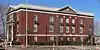 Tifereth Israel Synagogue |
May 9, 1985 (#85000958) |
344 S. 18th St. 40°48′38″N 96°41′42″W |
Lincoln | Now Tifereth Place Apts.[12] |
| 93 | William H. Tyler House | _from_W_1.JPG.webp) William H. Tyler House |
April 6, 1978 (#78001704) |
808 D St. 40°48′10″N 96°42′35″W |
Lincoln | |
| 94 | University Place Historic Residential District | 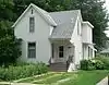 University Place Historic Residential District |
February 7, 2003 (#03000069) |
Roughly Walker Ave., 51st-54th Sts., Leighton Ave., and 49th-53rd Sts. 40°50′09″N 96°39′06″W |
Lincoln | |
| 95 | Veith Building | _from_S_1.JPG.webp) Veith Building |
September 18, 1980 (#80002454) |
816 P St. 40°48′54″N 96°42′34″W |
Lincoln | |
| 96 | Albert Watkins House | _from_S_2.JPG.webp) Albert Watkins House |
April 3, 1989 (#89000244) |
920 D St. 40°48′10″N 96°42′28″W |
Lincoln | |
| 97 | Wesleyan Hospital and Nurses Training School | 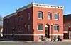 Wesleyan Hospital and Nurses Training School |
November 12, 2015 (#15000794) |
2742 N. 48th St. 40°50′25″N 96°39′12″W |
Lincoln | |
| 98 | Whitehall | _from_SE_1.JPG.webp) Whitehall |
October 29, 1982 (#82000610) |
5903 Walker 40°50′10″N 96°38′24″W |
Lincoln | |
| 99 | Woods Brothers Building | _from_NW_1.JPG.webp) Woods Brothers Building |
September 18, 1980 (#80002455) |
132 S. 13th St. 40°48′46″N 96°42′09″W |
Lincoln | |
| 100 | Frank and Nelle Cochrane Woods House | _from_NE_1.JPG.webp) Frank and Nelle Cochrane Woods House |
June 30, 1995 (#95000793) |
2501 Sheridan Boulevard 40°47′14″N 96°41′04″W |
Lincoln | |
| 101 | Woodsshire Residential Historic District |  Woodsshire Residential Historic District |
March 29, 2011 (#11000147) |
Bounded by High and Calvert Sts., South 17th to South 20th Sts. 40°46′45″N 96°41′41″W |
Lincoln | |
| 102 | Wyuka Cemetery | 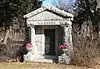 Wyuka Cemetery |
July 19, 1982 (#82003198) |
3600 O St. 40°49′01″N 96°39′54″W |
Lincoln | |
| 103 | John H. and Christina Yost House | _from_SW_2.JPG.webp) John H. and Christina Yost House |
April 26, 2002 (#02000410) |
1900 S. 25th St. 40°47′36″N 96°41′08″W |
Lincoln | |
| 104 | Arthur C. Ziemer House | 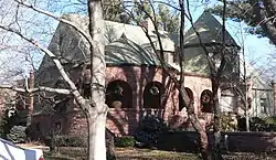 Arthur C. Ziemer House |
November 23, 1977 (#77000832) |
2030 Euclid Ave. 40°47′40″N 96°41′28″W |
Lincoln |
Former listings
| [3] | Name on the Register | Image | Date listed | Date removed | Location | City or town | Summary |
|---|---|---|---|---|---|---|---|
| 1 | Baldwin Terrace | 1979 (#79003687) | March 14, 2007 | 429–443 S. 12th St., and 1134–1142 K St. |
Lincoln | ||
| 2 | Beal Slough Bridge | Beal Slough Bridge |
June 29, 1992 (#92000744) | March 25, 2019 | W. Pioneers Boulevard over Beal Slough, 0.5 miles (0.80 km) west of Lincoln 40°46′13″N 96°42′46″W |
Lincoln | Bridge no longer extant; replaced ca. 2004.[13] Part of the Highway Bridges in Nebraska Multiple Property Submission (MPS). |
| 3 | Ehlers Round Barn |  Ehlers Round Barn |
June 30, 1995 (#95000799) | December 31, 2013 | 12200 S. 110th Street 40°41′31″N 96°34′16″W |
Roca | Destroyed in a 2012 snowstorm.[14] |
| 4 | Metropolitan Apartments | January 19, 1988 (#87002298) | March 14, 2007 | 502 South Twelfth Street |
Lincoln | ||
| 5 | Olive Branch Bridge | 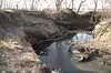 Olive Branch Bridge |
June 29, 1992 (#92000739) | December 31, 2013 | W. Stagecoach Rd. over Olive Brook, 1.7 miles (2.7 km) southwest of Sprague 40°36′37″N 96°46′28″W |
Sprague | Bridge no longer extant.[15] Part of the Highway Bridges in Nebraska MPS. |
| 6 | Townsend Photography Studio | December 20, 1984 (#84000478) | March 14, 2007 | 226 South 11th Street |
Lincoln |
See also
| Wikimedia Commons has media related to National Register of Historic Places in Lancaster County, Nebraska. |
References
- The latitude and longitude information provided in this table was derived originally from the National Register Information System, which has been found to be fairly accurate for about 99% of listings. Some locations in this table may have been corrected to current GPS standards.
- "National Register of Historic Places: Weekly List Actions". National Park Service, United States Department of the Interior. Retrieved on January 29, 2021.
- Numbers represent an alphabetical ordering by significant words. Various colorings, defined here, differentiate National Historic Landmarks and historic districts from other NRHP buildings, structures, sites or objects.
- The eight-digit number below each date is the number assigned to each location in the National Register Information System database, which can be viewed by clicking the number.
- "Prairie Hill Learning Center". Retrieved 2012-03-21.
- The boundaries of this NRHP-listed site were expanded July 28, 2004, to add 100 acres of farmland to the previous 20-acre plot, which had encompassed the farm's buildings. The NRHP reference number for the expansion is 04000750; see "National Register of Historic Places Registration Form: Herter Farmstead - Boundary Increase." Nebraska State Historical Society. Retrieved 2012-11-23.
- "Sorority Chapters". Archived 2012-02-28 at the Wayback Machine University of Nebraska—Lincoln. Retrieved 2012-02-13.
- Boundaries of NRHP site extended July 3, 2007; the reference number for the extension is 07000657.
- Hill, A.T., and Paul Cooper. "The Schrader Site: Prehistoric Village in Lancaster County, Nebraska." Nebraska History Magazine 17.4 (1936): 223-252: 224.
- Blackman, E.E. "Report of Department of Archeology". Annual Report: Nebraska State Board of Agriculture for the Year 1902. Robert W. Furnas, ed. Lincoln: State Journal, 1903. 294-326: 296.
- "South Street Temple: Congregation B'nai Jeshurun". Retrieved 2012-01-13.
- See photo.
- See 2012 photos of bridge at Commons:Category:Beal Slough Pioneers Blvd bridge (Lincoln, Nebraska). The Lancaster County Board of Commissioners voted to replace the bridge April 8, 2004 (see minutes). Bridge is not listed in Nebraska State Historical Society's "Nebraska National Register Sites in Lancaster County" page.
- Siddiqui, Faiz. "Snowstorm damages historic round barn". Lincoln Journal Star. 2012-02-05. Retrieved 2015-04-15.
- See photos.
| Topics | |
|---|---|
| Lists by state |
|
| Lists by insular areas | |
| Lists by associated state | |
| Other areas | |
| Related | |
| |
Municipalities and communities of Lancaster County, Nebraska, United States | ||
|---|---|---|
| Cities | Map of Nebraska highlighting Lancaster County | |
| Villages | ||
| CDPs | ||
| Other unincorporated communities | ||
| Footnotes | ‡This populated place also has portions in an adjacent county or counties | |
| ||
This article is issued from Wikipedia. The text is licensed under Creative Commons - Attribution - Sharealike. Additional terms may apply for the media files.