National Register of Historic Places listings in Lassen Volcanic National Park
This is a list of the National Register of Historic Places listings in Lassen Volcanic National Park.
This is intended to be a complete list of the properties and districts on the National Register of Historic Places in Lassen Volcanic National Park, California, United States. The locations of National Register properties and districts for which the latitude and longitude coordinates are included below, may be seen in a Google map.[1]
There are 13 properties and districts listed on the National Register in the park.
- This National Park Service list is complete through NPS recent listings posted February 5, 2021.[2]
Current listings
| [3] | Name on the Register | Image | Date listed[4] | Location | City or town | Description |
|---|---|---|---|---|---|---|
| 1 | Drakesbad Guest Ranch | 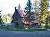 Drakesbad Guest Ranch |
October 22, 2003 (#03001062) |
Head of Warner Creek Valley, Lassen Volcanic National Park 40°26′23″N 121°24′52″W |
Chester | |
| 2 | Horseshoe Lake Ranger Station | 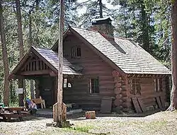 Horseshoe Lake Ranger Station |
May 5, 1978 (#78000292) |
N of Chester in Lassen Volcanic National Park 40°28′23″N 121°19′48″W |
Chester | |
| 3 | Lassen Volcanic National Park Highway Historic District | 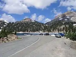 Lassen Volcanic National Park Highway Historic District |
June 23, 2006 (#06000527) |
NPS Route 1, CA 89 40°30′02″N 121°30′38″W |
Mineral | |
| 4 | Loomis Visitor Center, Bldg. 43 | 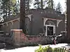 Loomis Visitor Center, Bldg. 43 |
February 25, 1975 (#75000177) |
Lassen Volcanic National Park 40°32′10″N 121°33′44″W |
Manzanita Lake | |
| 5 | Manzanita Lake Naturalist's Services Historic District | 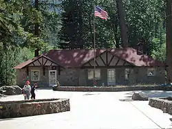 Manzanita Lake Naturalist's Services Historic District |
June 23, 2006 (#06000525) |
39489 CA 44 40°32′08″N 121°33′51″W |
Shingletown | |
| 6 | Mount Harkness Fire Lookout | .jpg.webp) Mount Harkness Fire Lookout |
June 19, 2017 (#100001211) |
40°18′40″N 121°18′06″W |
Mineral | |
| 7 | Nobles Emigrant Trail |  Nobles Emigrant Trail |
October 3, 1975 (#75000222) |
E of Shingletown in Lassen Volcanic National Park 40°32′50″N 121°25′29″W |
Shingletown | |
| 8 | Park Headquarters, Lassen Volcanic National Park | 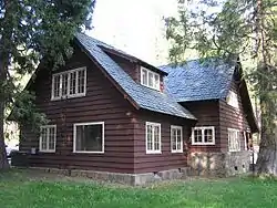 Park Headquarters, Lassen Volcanic National Park |
October 3, 1978 (#06000490) |
Off CA 36 40°20′45″N 121°36′27″W |
Mineral | |
| 9 | Prospect Peak Fire Lookout | March 30, 1978 (#78000295) |
40°34′24″N 121°20′42″W |
Mineral | ||
| 10 | Sulphur Creek Archeological District | April 14, 1980 (#80000370) |
Coordinates missing |
Mill Creek | ||
| 11 | Summit Lake Ranger Station | 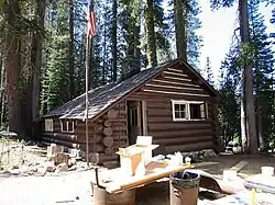 Summit Lake Ranger Station |
April 3, 1978 (#78000296) |
NE of Mineral in Lassen Volcanic National Park 40°29′54″N 121°25′37″W |
Mineral | |
| 12 | Twin Lakes Fire Tool Cache | October 25, 2016 (#16000745) |
40°30′46″N 121°21′47″W |
Mineral vicinity | ||
| 13 | Warner Valley Ranger Station | .jpg.webp) Warner Valley Ranger Station |
April 3, 1978 (#78000364) |
N of Chester in Lassen Volcanic National Park 40°26′28″N 121°22′57″W |
Chester |
See also
- National Register of Historic Places listings in Lassen County, California
- National Register of Historic Places listings in Plumas County, California
- National Register of Historic Places listings in Shasta County, California
- National Register of Historic Places listings in Tehama County, California
- National Register of Historic Places listings in California
References
- Emmons, Ann; Catton, Ted. National Register of Historic Places Multiple Property Documentation Form: Lassen Volcanic National Park Multiple Property Listing. National Park Service February 2004 https://npgallery.nps.gov/NRHP/GetAsset/NRHP/64500949_text
- The latitude and longitude information provided in this table was derived originally from the National Register Information System, which has been found to be fairly accurate for about 99% of listings. Some locations in this table may have been corrected to current GPS standards.
- "National Register of Historic Places: Weekly List Actions". National Park Service, United States Department of the Interior. Retrieved on February 5, 2021.
- Numbers represent an alphabetical ordering by significant words. Various colorings, defined here, differentiate National Historic Landmarks and historic districts from other NRHP buildings, structures, sites or objects.
- The eight-digit number below each date is the number assigned to each location in the National Register Information System database, which can be viewed by clicking the number.
| Topics | |
|---|---|
| Lists by state |
|
| Lists by insular areas | |
| Lists by associated state | |
| Other areas | |
| Related | |
| |
| Wikimedia Commons has media related to National Register of Historic Places in Lassen Volcanic National Park. |
This article is issued from Wikipedia. The text is licensed under Creative Commons - Attribution - Sharealike. Additional terms may apply for the media files.