National Register of Historic Places listings in Walsh County, North Dakota
This is a list of the National Register of Historic Places listings in Walsh County, North Dakota.
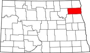
Location of Walsh County in North Dakota
This is intended to be a complete list of the properties and districts on the National Register of Historic Places in Walsh County, North Dakota, United States. The locations of National Register properties and districts for which the latitude and longitude coordinates are included below, may be seen in a map.[1]
There are 16 properties and districts listed on the National Register in the county. Another property was once listed but has been removed.
| Adams | Barnes | Benson | Billings | Bottineau | Bowman | Burke | Burleigh | Cass | Cavalier | Dickey | Divide | Dunn | Eddy | Emmons | Foster | Golden Valley | Grand Forks | Grant | Griggs | Hettinger | Kidder | La Moure | Logan | McHenry | McIntosh | McKenzie | McLean | Mercer | Morton | Mountrail | Nelson | Oliver | Pembina | Pierce | Ramsey | Ransom | Renville | Richland | Rolette | Sargent | Sheridan | Sioux | Slope | Stark | Steele | Stutsman | Towner | Traill | Walsh | Ward | Wells | Williams |
- This National Park Service list is complete through NPS recent listings posted January 29, 2021.[2]
Current listings
| [3] | Name on the Register[4] | Image | Date listed[5] | Location | City or town | Description |
|---|---|---|---|---|---|---|
| 1 | District No. 70-Hoff Rural School | March 20, 2008 (#08000233) |
Fire No. 6591 123rd Ave., NE. (Norton Township) 48°22′08″N 97°59′23″W |
Adams | ||
| 2 | Edinburg WPA Auditorium | November 7, 2013 (#13000863) |
67 Main St. 48°29′45″N 97°51′51″W |
Edinburg | Federal Relief Construction in North Dakota, 1931-1943, MPS | |
| 3 | Elmwood | February 21, 1985 (#85000339) |
P.O. Box 654 48°25′19″N 97°24′18″W |
Grafton | ||
| 4 | Forest River State Bank | 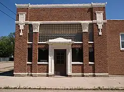 Forest River State Bank |
December 5, 2019 (#100004715) |
110 Front St. 48°12′50″N 97°28′07″E |
Forest River | |
| 5 | Grafton State School | 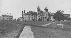 Grafton State School |
November 6, 1996 (#96001191) |
700 6th St., W. 48°25′07″N 97°25′26″W |
Grafton | |
| 6 | Minto School | January 30, 1992 (#91002002) |
Junction of Major Ave. and 3rd St. 48°17′35″N 97°22′25″W |
Minto | ||
| 7 | Nordre Trefoldegheds Menigheds | February 20, 2004 (#04000058) |
6 miles west and 3/8 miles south of the junction of U.S. Route 81 and County Road 9 48°27′56″N 97°33′28″W |
Nash | ||
| 8 | Pisek School | 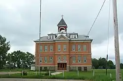 Pisek School |
March 17, 1994 (#94000220) |
Eastern end of Main St. at Lovcik Ave. 48°18′37″N 97°42′21″W |
Pisek | |
| 9 | Ridge Trail Historic District | March 17, 2006 (#05001333) |
Address Restricted |
Kensington | Historic trail segments in Walsh and Pembina Counties. | |
| 10 | St. Catherine's Church of Lomice, North Dakota | 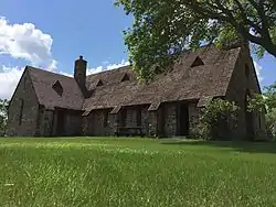 St. Catherine's Church of Lomice, North Dakota |
April 12, 2006 (#06000249) |
4 miles west and 2 miles south of the junction of ND 35 and County Road 15 48°16′53″N 98°12′35″W |
Whitman | |
| 11 | St. Joseph's Chapel | June 2, 1994 (#94000556) |
Between Interstate 29 and the Red River, east of Minto, in Pulaski Township 48°18′35″N 97°08′42″W |
Minto | ||
| 12 | St. Stanislaus Church Historic District | 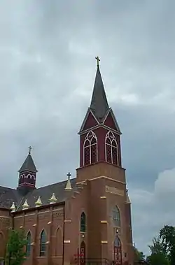 St. Stanislaus Church Historic District |
August 3, 1979 (#79001776) |
Off Interstate 29 48°17′41″N 97°15′11″W |
Warsaw | |
| 13 | State Bank of Edinburg | May 30, 2001 (#01000588) |
300 Main Ave. 48°29′45″N 97°51′52″W |
Edinburg | ||
| 14 | Strand Theatre | 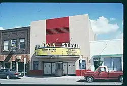 Strand Theatre |
April 14, 2004 (#04000299) |
618 Hill Ave. 48°25′05″N 97°24′37″W |
Grafton | |
| 15 | US Post Office-Grafton | November 1, 1989 (#89001756) |
506 S. Griggs Ave. 48°25′09″N 97°24′42″W |
Grafton | ||
| 16 | Walsh County Courthouse | 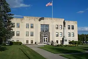 Walsh County Courthouse |
November 25, 1985 (#85002992) |
638 Cooper Ave. 48°25′06″N 97°24′15″W |
Grafton |
Former listing
| [3] | Name on the Register | Image | Date listed | Date removed | Location | City or town | Summary |
|---|---|---|---|---|---|---|---|
| 1 | Odalen Lutherske Kirke | January 11, 2006 (#05001517) | November 28, 2007 | 6 miles west and ¼ miles north of the junction of ND 32 and County Road 9 in Tiber Township 48°25′06″N 97°24′15″W |
Edinburg | Burned to ground on June 21, 2007. Cemetery which was included in listing remains, but was delisted November 28, 2007 |
See also
| Wikimedia Commons has media related to National Register of Historic Places in Walsh County, North Dakota. |
References
- The latitude and longitude information provided in this table was derived originally from the National Register Information System, which has been found to be fairly accurate for about 99% of listings. Some locations in this table may have been corrected to current GPS standards.
- "National Register of Historic Places: Weekly List Actions". National Park Service, United States Department of the Interior. Retrieved on January 29, 2021.
- Numbers represent an alphabetical ordering by significant words. Various colorings, defined here, differentiate National Historic Landmarks and historic districts from other NRHP buildings, structures, sites or objects.
- "National Register Information System". National Register of Historic Places. National Park Service. April 24, 2008.
- The eight-digit number below each date is the number assigned to each location in the National Register Information System database, which can be viewed by clicking the number.
| Topics | |
|---|---|
| Lists by state |
|
| Lists by insular areas | |
| Lists by associated state | |
| Other areas | |
| Related | |
| |
Municipalities and communities of Walsh County, North Dakota, United States | ||
|---|---|---|
| Cities | Map of North Dakota highlighting Walsh County | |
| Townships | ||
| CDPs | ||
| Unincorporated communities | ||
| ||
This article is issued from Wikipedia. The text is licensed under Creative Commons - Attribution - Sharealike. Additional terms may apply for the media files.