National Register of Historic Places listings in McHenry County, North Dakota
This is a list of the National Register of Historic Places listings in McHenry County, North Dakota.
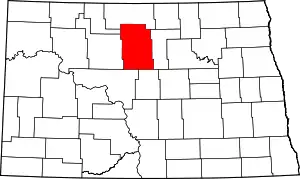
Location of McHenry County in North Dakota
This is intended to be a complete list of the properties and districts on the National Register of Historic Places in McHenry County, North Dakota, United States. The locations of National Register properties and districts for which the latitude and longitude coordinates are included below, may be seen in a map.[1]
There are 12 properties and districts listed on the National Register in the county.
| Adams | Barnes | Benson | Billings | Bottineau | Bowman | Burke | Burleigh | Cass | Cavalier | Dickey | Divide | Dunn | Eddy | Emmons | Foster | Golden Valley | Grand Forks | Grant | Griggs | Hettinger | Kidder | La Moure | Logan | McHenry | McIntosh | McKenzie | McLean | Mercer | Morton | Mountrail | Nelson | Oliver | Pembina | Pierce | Ramsey | Ransom | Renville | Richland | Rolette | Sargent | Sheridan | Sioux | Slope | Stark | Steele | Stutsman | Towner | Traill | Walsh | Ward | Wells | Williams |
- This National Park Service list is complete through NPS recent listings posted January 29, 2021.[2]
Current listings
| [3] | Name on the Register | Image | Date listed[4] | Location | City or town | Description |
|---|---|---|---|---|---|---|
| 1 | Denbigh Station and Experimental Forest | June 24, 2010 (#10000380) |
U.S. Route 2 48°17′25″N 100°38′12″W |
Denbigh | ||
| 2 | Elliott Bridge | February 27, 1997 (#97000181) |
Unnamed county road across the Souris River, approximately 4 miles north of Towner 48°24′27″N 100°23′45″W |
Towner | ||
| 3 | Granville State Bank | 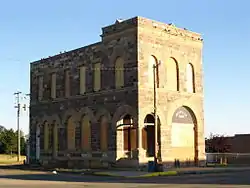 Granville State Bank |
September 13, 1977 (#77001509) |
Main and 2nd Sts. 48°16′02″N 100°50′03″W |
Granville | |
| 4 | Hotel Berry | 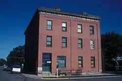 Hotel Berry |
October 20, 1982 (#82001343) |
100 W. Central Ave. 48°03′36″N 100°55′54″W |
Velva | |
| 5 | Liberty Baptist Church | 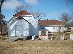 Liberty Baptist Church |
October 16, 1987 (#87001789) |
5th and Christina Sts. 47°51′24″N 100°31′29″W |
Kief | |
| 6 | Lower Souris National Wildlife Refuge Airplane Hangar | 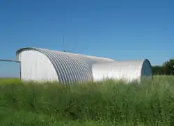 Lower Souris National Wildlife Refuge Airplane Hangar |
September 20, 2011 (#11000140) |
681 Salyer Rd. 48°36′40″N 100°43′10″W |
Upham | |
| 7 | McHenry County Courthouse | 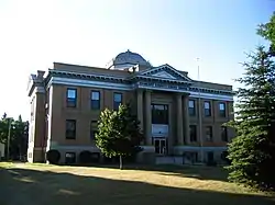 McHenry County Courthouse |
November 25, 1980 (#80002917) |
In Towner 48°20′35″N 100°24′13″W |
Towner | |
| 8 | Norway Lutheran Church and Cemetery | .jpg.webp) Norway Lutheran Church and Cemetery |
October 14, 1994 (#94001216) |
10 miles south of Denbigh, south of the Souris River 48°10′56″N 100°36′51″W |
Denbigh | |
| 9 | Old Saint John Nepomocene Cemetery, Wrought-Iron Cross Site | October 23, 1989 (#89001683) |
Address Restricted |
Orrin | ||
| 10 | Old Saints Peter and Paul Cemetery, Wrought-Iron Cross Site | 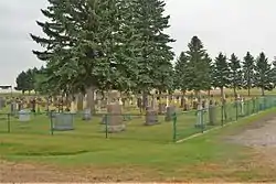 Old Saints Peter and Paul Cemetery, Wrought-Iron Cross Site |
October 23, 1989 (#89001682) |
Address Restricted |
Karlsruhe | |
| 11 | Alfred and Clara Sevareid House | 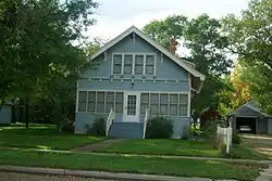 Alfred and Clara Sevareid House |
October 3, 1996 (#96001066) |
405 2nd St., W. 48°03′41″N 100°55′51″W |
Velva | |
| 12 | Westgaard Bridge | 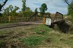 Westgaard Bridge |
February 27, 1997 (#97000180) |
Unnamed county road across the Sheyenne River, approximately 6 miles north and 1 mile east of Voltaire 48°06′51″N 100°48′33″W |
Voltaire |
See also
| Wikimedia Commons has media related to National Register of Historic Places in McHenry County, North Dakota. |
References
- The latitude and longitude information provided in this table was derived originally from the National Register Information System, which has been found to be fairly accurate for about 99% of listings. Some locations in this table may have been corrected to current GPS standards.
- "National Register of Historic Places: Weekly List Actions". National Park Service, United States Department of the Interior. Retrieved on January 29, 2021.
- Numbers represent an alphabetical ordering by significant words. Various colorings, defined here, differentiate National Historic Landmarks and historic districts from other NRHP buildings, structures, sites or objects.
- The eight-digit number below each date is the number assigned to each location in the National Register Information System database, which can be viewed by clicking the number.
| Topics | |
|---|---|
| Lists by state |
|
| Lists by insular areas | |
| Lists by associated state | |
| Other areas | |
| Related | |
| |
Municipalities and communities of McHenry County, North Dakota, United States | ||
|---|---|---|
| Cities | Map of North Dakota highlighting McHenry County | |
| Townships |
| |
| Unorganized territory |
| |
| Unincorporated communities | ||
| Indian reservation | ||
| Footnotes | ‡This populated place also has portions in an adjacent county or counties | |
| ||
This article is issued from Wikipedia. The text is licensed under Creative Commons - Attribution - Sharealike. Additional terms may apply for the media files.