National Register of Historic Places listings in Yankton County, South Dakota
This is a list of the National Register of Historic Places listings in Yankton County, South Dakota.
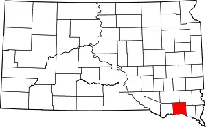
Location of Yankton County in South Dakota
This is intended to be a complete list of the properties and districts on the National Register of Historic Places in Yankton County, South Dakota, United States. The locations of National Register properties and districts for which the latitude and longitude coordinates are included below, may be seen in a map.[1]
There are 79 properties and districts listed on the National Register in the county. Another property was once listed but has since been removed.
- This National Park Service list is complete through NPS recent listings posted January 29, 2021.[2]
Current listings
| [3] | Name on the Register[4] | Image | Date listed[5] | Location | City or town | Description |
|---|---|---|---|---|---|---|
| 1 | Aggergaard Manor | _from_SE_2.JPG.webp) Aggergaard Manor |
June 6, 2001 (#01000636) |
Thompson St. 43°05′09″N 97°09′55″W |
Irene | |
| 2 | Dr. B.M. Banton House | _from_SE_2.JPG.webp) Dr. B.M. Banton House |
October 8, 1987 (#87001729) |
517 Locust St. 42°52′24″N 97°23′59″W |
Yankton | |
| 3 | Bishop Marty Rectory | 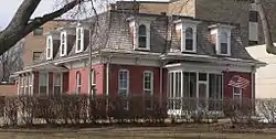 Bishop Marty Rectory |
December 27, 1974 (#74001900) |
1101 W. 5th St. 42°52′16″N 97°24′29″W |
Yankton | |
| 4 | Brockmueller Barn | April 16, 1980 (#80003757) |
South of Highway 46 43°02′34″N 97°19′10″W |
Volin | part of the Northern and Central Townships of Yankton Multiple Resource Area (MRA) | |
| 5 | Bruce-Donaldson House | 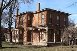 Bruce-Donaldson House |
March 5, 1982 (#82003946) |
313 Pine St. 42°52′14″N 97°23′20″W |
Yankton | |
| 6 | Burns House | 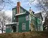 Burns House |
February 9, 2001 (#01000094) |
816 Pine St. 42°52′39″N 97°23′18″W |
Yankton | |
| 7 | Chicago, Milwaukee and St. Paul Depot | 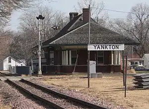 Chicago, Milwaukee and St. Paul Depot |
March 5, 1982 (#82003947) |
8th and Douglas Sts. 42°52′35″N 97°23′27″W |
Yankton | |
| 8 | DeJong House | _from_E_1.jpg.webp) DeJong House |
April 16, 1980 (#80003750) |
In Utica 42°58′50″N 97°29′56″W |
Utica | part of the Northern and Central Townships of Yankton MRA |
| 9 | Harold A. (H.A.) Doyle House | _from_SW.JPG.webp) Harold A. (H.A.) Doyle House |
October 25, 1990 (#90001645) |
712 W. 3rd St. 42°52′13″N 97°24′08″W |
Yankton | |
| 10 | Arthur C. Ellerman House | 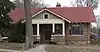 Arthur C. Ellerman House |
March 5, 1982 (#82003948) |
708 W. 5th St. 42°52′22″N 97°24′08″W |
Yankton | |
| 11 | ES Volin Farmstead | April 16, 1980 (#80003758) |
Southeast of Volin 42°57′07″N 97°10′22″W |
Volin | part of the Northern and Central Townships of Yankton MRA | |
| 12 | Excelsior Flour Mill | _from_NW_1.JPG.webp) Excelsior Flour Mill |
November 7, 1976 (#76001757) |
106 Capital Street[6] 42°52′04″N 97°23′25″W |
Yankton | |
| 13 | William J. Fantle House | 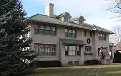 William J. Fantle House |
October 10, 1989 (#89001588) |
1201 Douglas 42°52′57″N 97°23′31″W |
Yankton | |
| 14 | Gordon House | April 16, 1980 (#80003736) |
North of Highway 46 43°06′03″N 97°19′13″W |
Irene | part of the Northern and Central Townships of Yankton MRA | |
| 15 | Gorsett Farmstead | April 16, 1980 (#80003759) |
North of Volin 42°58′56″N 97°11′11″W |
Volin | part of the Northern and Central Townships of Yankton MRA | |
| 16 | Endre B. Gunderson Farmstead | April 16, 1980 (#80003769) |
North of Yankton 42°56′11″N 97°24′59″W |
Yankton | part of the Northern and Central Townships of Yankton MRA | |
| 17 | Charles Gurney Hotel | 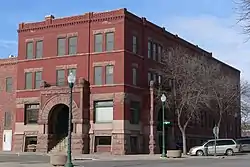 Charles Gurney Hotel |
August 3, 1979 (#79002410) |
3rd and Capital Sts. 42°52′12″N 97°23′26″W |
Yankton | |
| 18 | Bernt Gustad House | April 16, 1980 (#80003760) |
Northwest of Volin 42°58′10″N 97°20′13″W |
Volin | part of the Northern and Central Townships of Yankton MRA | |
| 19 | Henjna Farmstead | _from_SE_2_long.JPG.webp) Henjna Farmstead |
April 16, 1980 (#80003770) |
North of Highway 50 42°56′31″N 97°33′41″W |
Yankton | part of the Northern and Central Townships of Yankton MRA |
| 20 | Hoffman House | _from_SE.JPG.webp) Hoffman House |
November 20, 2007 (#07001216) |
307 Green St. 42°52′10″N 97°24′08″W |
Yankton | |
| 21 | House of Gurney Historic District | House of Gurney Historic District |
August 21, 2012 (#12000536) |
106, 109, & 110 Capital St. 42°52′04″N 97°23′26″W |
Yankton | |
| 22 | Hoxeng Farmstead | April 16, 1980 (#80003761) |
Northwest of Volin 42°59′16″N 97°12′42″W |
Volin | part of the Northern and Central Townships of Yankton MRA | |
| 23 | Human Services Center | 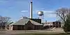 Human Services Center |
April 16, 1980 (#80003771) |
Off U.S. Route 81 42°54′52″N 97°25′40″W |
Yankton | part of the Northern and Central Townships of Yankton MRA |
| 24 | Ingebrigtsen-Hinseth Farmstead | April 16, 1980 (#80003737) |
West of Irene 43°05′24″N 97°12′30″W |
Irene | part of the Northern and Central Townships of Yankton MRA | |
| 25 | Jencks Farmstead | April 16, 1980 (#80003772) |
North of Yankton, off U.S. Route 81 42°55′14″N 97°22′40″W |
Yankton | part of the Northern and Central Townships of Yankton MRA | |
| 26 | Kietzman Farmstead | April 16, 1980 (#80003773) |
Northeast of Utica 43°00′47″N 97°24′35″W |
Yankton | part of the Northern and Central Townships of Yankton MRA | |
| 27 | Kremer House | April 16, 1980 (#80003738) |
In Lesterville 43°02′26″N 97°35′43″W |
Lesterville | part of the Northern and Central Townships of Yankton MRA | |
| 28 | Larson-Simonson House | April 16, 1980 (#80003742) |
In Mission Hill 42°55′19″N 97°16′48″W |
Mission Hill | part of the Northern and Central Townships of Yankton MRA | |
| 29 | Mathias Lasele House | April 16, 1980 (#80003739) |
East of Lesterville 43°03′40″N 97°31′51″W |
Lesterville | part of the Northern and Central Townships of Yankton MRA | |
| 30 | Machacek Homestead | April 16, 1980 (#80003751) |
Southwest of Utica 42°57′35″N 97°30′57″W |
Utica | part of the Northern and Central Townships of Yankton MRA | |
| 31 | Marindahl Post Office | April 16, 1980 (#80003762) |
Northwest of Volin 42°59′49″N 97°14′01″W |
Volin | part of the Northern and Central Townships of Yankton MRA | |
| 32 | Marindahl Township Hall | April 16, 1980 (#80003763) |
Southwest of Irene 43°02′23″N 97°14′02″W |
Volin | part of the Northern and Central Townships of Yankton MRA | |
| 33 | Martin's Evangelical Church | _from_SW_2.JPG.webp) Martin's Evangelical Church |
April 16, 1980 (#80003752) |
43804 300 St.[7] 43°02′22″N 97°26′16″W |
Utica | part of the Northern and Central Townships of Yankton MRA |
| 34 | Walker McGregor Farmstead | April 16, 1980 (#80003774) |
Northwest of Volin 42°58′22″N 97°12′44″W |
Yankton | part of the Northern and Central Townships of Yankton MRA | |
| 35 | Meridian Bridge | 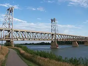 Meridian Bridge |
June 17, 1993 (#93000537) |
U.S. Route 81 over the Missouri River, just south of Yankton 42°52′05″N 97°23′37″W |
Yankton | Extends into Cedar County, Nebraska; part of the Highway Bridges in Nebraska Multiple Property Submission (MPS) |
| 36 | Nels Merk Farmstead | April 16, 1980 (#80003775) |
Southeast of Center Point 43°08′47″N 97°10′49″W |
Yankton | part of the Northern and Central Townships of Yankton MRA | |
| 37 | Mathias Merkwan Rubblestone Barn | 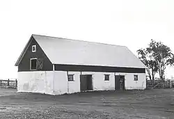 Mathias Merkwan Rubblestone Barn |
July 6, 1987 (#87001055) |
East of Tabor 42°57′01″N 97°37′57″W |
Tabor | part of the Czech Folk Architecture in Southeastern South Dakota MRA |
| 38 | Mueller Homestead | April 16, 1980 (#80003753) |
East of Lesterville 43°02′45″N 97°30′43″W |
Utica | part of the Northern and Central Townships of Yankton MRA | |
| 39 | New Hope Farm Polygonal Barn | January 28, 2004 (#03001537) |
30725 444th Ave. 42°57′37″N 97°19′17″W |
Mission Hill | part of the South Dakota's Round and Polygonal Barns and Pavilions MPS | |
| 40 | New Hope Farm Swine Barn | January 28, 2004 (#03001538) |
30725 444th Ave. 42°55′58″N 97°19′26″W |
Mission Hill | ||
| 41 | Ohlman-Shannon House | 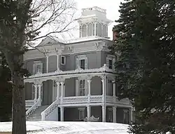 Ohlman-Shannon House |
May 28, 1976 (#76001758) |
205 Green St. 42°52′11″N 97°24′06″W |
Yankton | |
| 42 | Old Catholic Church | _from_SE_2.JPG.webp) Old Catholic Church |
April 16, 1980 (#80003776) |
43064 Lake Port Road[8] 42°54′52″N 97°34′58″W |
Yankton | part of the Northern and Central Townships of Yankton MRA |
| 43 | Lewis Olson Log House | April 16, 1980 (#80003743) |
West of Mission Hill 42°55′58″N 97°20′17″W |
Mission Hill | part of the Northern and Central Townships of Yankton MRA | |
| 44 | Our Savior's Lutheran Church | _interior_1.2.JPG.webp) Our Savior's Lutheran Church |
October 7, 2001 (#01001078) |
29219 431st Ave. 43°09′08″N 97°34′46″W |
Menno | |
| 45 | Frantisek Pechan Log House | July 6, 1987 (#87001054) |
North of Highways 50 and 52 42°54′51″N 97°32′23″W |
Tabor | part of the Czech Folk Architecture in Southeastern South Dakota MRA | |
| 46 | Governor John L. Pennington House | 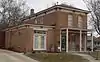 Governor John L. Pennington House |
February 8, 1988 (#88000025) |
410 E. 3rd St. 42°52′12″N 97°23′08″W |
Yankton | |
| 47 | Mathias Peterson Homestead | April 16, 1980 (#80003744) |
Southwest of Volin 42°56′19″N 97°14′03″W |
Mission Hill | part of the Northern and Central Townships of Yankton MRA | |
| 48 | Pine Street Bridge | 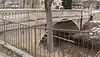 Pine Street Bridge |
January 14, 2000 (#99001697) |
Pine Street over Marne Creek 42°52′27″N 97°23′19″W |
Yankton | part of the Historic Bridges in South Dakota MPS |
| 49 | Ripple House | April 16, 1980 (#80003740) |
South of Lesterville 43°01′49″N 97°35′47″W |
Lesterville | part of the Northern and Central Townships of Yankton MRA | |
| 50 | St. Agnes Church | _from_NE_2_locn.JPG.webp) St. Agnes Church |
April 16, 1980 (#80003754) |
43883 300 St.[9] 43°02′21″N 97°25′19″W |
Utica | part of the Northern and Central Townships of Yankton MRA |
| 51 | Schaffer Farmstead | April 16, 1980 (#80003777) |
North of Yankton, off U.S. Route 81 42°55′53″N 97°22′42″W |
Yankton | part of the Northern and Central Townships of Yankton MRA | |
| 52 | Fred Schnauber House | 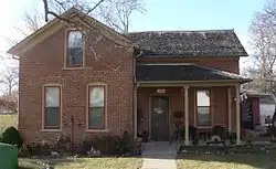 Fred Schnauber House |
January 31, 1985 (#85000185) |
717 Walnut St. 42°52′34″N 97°23′37″W |
Yankton | |
| 53 | Scottish Rite Masonic Temple | _from_NE_1.JPG.webp) Scottish Rite Masonic Temple |
January 23, 2013 (#12001219) |
333 Cedar Street 42°52′15″N 97°23′45″W |
Yankton | |
| 54 | Simonson Farmstead | April 16, 1980 (#80003745) |
Southwest of Volin 42°56′00″N 97°13′11″W |
Mission Hill | part of the Northern and Central Townships of Yankton MRA | |
| 55 | John Sloan Homestead | April 16, 1980 (#80003764) |
Southwest of Irene 43°01′28″N 97°11′53″W |
Volin | part of the Northern and Central Townships of Yankton MRA | |
| 56 | Jessie Smith Farmstead | April 16, 1980 (#80003765) |
Southwest of Volin 42°55′22″N 97°12′50″W |
Volin | part of the Northern and Central Townships of Yankton MRA | |
| 57 | Steingrube Place | January 28, 2004 (#03001539) |
30089 452nd Ave. 43°01′51″N 97°09′39″W |
Wakonda | part of the Northern and Central Townships of Yankton MRA | |
| 58 | Stribral Homestead and Farmstead | April 16, 1980 (#80003749) |
South of Lesterville 42°57′42″N 97°35′15″W |
Tabor | part of the Northern and Central Townships of Yankton MRA | |
| 59 | Frank Svatos Rubblestone Barn | July 6, 1987 (#87001056) |
Southeast of Tabor off Highway 50 42°56′08″N 97°37′43″W |
Tabor | part of the Czech Folk Architecture in Southeastern South Dakota MRA | |
| 60 | Dr. John Trierweiler House | 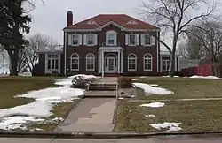 Dr. John Trierweiler House |
May 7, 1980 (#80003778) |
301 Spruce St. 42°52′13″N 97°24′15″W |
Yankton | |
| 61 | United Church of Christ | _from_S_1.JPG.webp) United Church of Christ |
April 16, 1980 (#80003746) |
3rd St. and Washington Ave.[10] 42°55′26″N 97°16′46″W |
Mission Hill | As of 2015, Harvest Independent Baptist Church[11] |
| 62 | Utica Depot | April 16, 1980 (#80003755) |
In Utica 42°58′50″N 97°29′56″W |
Utica | Moved to Pioneer Acres in Menno[12] | |
| 63 | Utica Fire and City Hall | 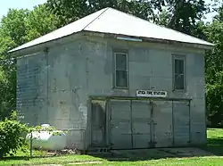 Utica Fire and City Hall |
April 16, 1980 (#80004591) |
In Utica 42°58′50″N 97°29′57″W |
Utica | part of the Northern and Central Townships of Yankton MRA |
| 64 | Utica Public School | 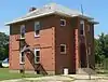 Utica Public School |
April 16, 1980 (#80003756) |
In Utica 42°58′48″N 97°29′57″W |
Utica | part of the Northern and Central Townships of Yankton MRA |
| 65 | Van Osdel House | _from_SE_1.jpg.webp) Van Osdel House |
April 16, 1980 (#80003747) |
In Mission Hill 42°55′11″N 97°16′51″W |
Mission Hill | part of the Northern and Central Townships of Yankton MRA |
| 66 | Vangen Church | 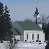 Vangen Church |
April 16, 1980 (#80003748) |
Northeastern Mission Hill 42°55′34″N 97°15′53″W |
Mission Hill | part of the Northern and Central Townships of Yankton MRA |
| 67 | Volin School | 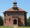 Volin School |
April 16, 1980 (#80003766) |
Main St. and Sherman Ave.[13] 42°57′38″N 97°10′56″W |
Volin | part of the Northern and Central Townships of Yankton MRA |
| 68 | Volin Town Hall | 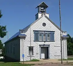 Volin Town Hall |
April 16, 1980 (#80003767) |
Main St. and Garfield Ave.[14] 42°57′31″N 97°10′54″W |
Volin | part of the Northern and Central Townships of Yankton MRA |
| 69 | Louis Volin House | April 16, 1980 (#80003768) |
Northwest of Volin 42°57′25″N 97°10′45″W |
Volin | part of the Northern and Central Townships of Yankton MRA | |
| 70 | Walloch Farmstead | April 16, 1980 (#80003741) |
South of Lesterville 43°00′27″N 97°36′44″W |
Lesterville | part of the Northern and Central Townships of Yankton MRA | |
| 71 | Walshtown School | April 16, 1980 (#80003779) |
South of Highway 46 43°02′22″N 97°19′11″W |
Yankton | part of the Northern and Central Townships of Yankton MRA | |
| 72 | Western Portland Cement Plant | _stack_1.JPG.webp) Western Portland Cement Plant |
September 19, 1979 (#79002411) |
West of Yankton 42°52′43″N 97°28′43″W |
Yankton | |
| 73 | Yankton Carnegie Library | 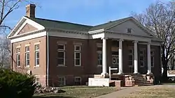 Yankton Carnegie Library |
August 7, 1979 (#79002412) |
4th and Capitol Sts. 42°52′17″N 97°23′26″W |
Yankton | |
| 74 | Yankton College Conservatory | 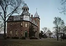 Yankton College Conservatory |
February 24, 1975 (#75001724) |
Yankton College campus 42°53′23″N 97°23′24″W |
Yankton | |
| 75 | Yankton College Historic District | 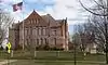 Yankton College Historic District |
March 22, 1982 (#82003949) |
12th and Douglas Sts. 42°52′49″N 97°23′22″W |
Yankton | |
| 76 | Yankton High School Historic District | Yankton High School Historic District |
May 30, 2002 (#02000578) |
613 Walnut St. 42°52′29″N 97°23′39″W |
Yankton | part of the Schools in South Dakota MPS |
| 77 | Yankton Historic Commercial District |  Yankton Historic Commercial District |
June 23, 1982 (#82003950) |
Roughly bounded by 2nd, 4th, Pine and Broadway Sts. 42°52′49″N 97°23′22″W |
Yankton | Boundary decrease approved August 24, 2018. |
| 78 | Yankton Historic District | February 13, 1975 (#75001725) |
Bounded by Marne Creek and 4th St., and including both sides of Cedar 42°52′22″N 97°23′21″W |
Yankton | ||
| 79 | Zion Lutheran Church | April 16, 1980 (#80004527) |
Northwest of Volin 42°59′47″N 97°13′23″W |
Volin | part of the Northern and Central Townships of Yankton MRA |
Former listing
| [3] | Name on the Register | Image | Date listed | Date removed | Location | City or town | Summary |
|---|---|---|---|---|---|---|---|
| 1 | Walnut Street Bridge | January 14, 2000 (#99001692) | March 26, 2008 | Walnut Street over Marne Creek |
Yankton | ||
| 2 | Yankton County Courthouse | September 3, 1976 (#76001759) | August 20, 2003 | 3rd St. and Broadway |
Yankton | Demolished in June 2003 |
See also
| Wikimedia Commons has media related to National Register of Historic Places in Yankton County, South Dakota. |
References
- The latitude and longitude information provided in this table was derived originally from the National Register Information System, which has been found to be fairly accurate for about 99% of listings. Some locations in this table may have been corrected to current GPS standards.
- "National Register of Historic Places: Weekly List Actions". National Park Service, United States Department of the Interior. Retrieved on January 29, 2021.
- Numbers represent an alphabetical ordering by significant words. Various colorings, defined here, differentiate National Historic Landmarks and historic districts from other NRHP buildings, structures, sites or objects.
- "National Register Information System". National Register of Historic Places. National Park Service. April 24, 2008.
- The eight-digit number below each date is the number assigned to each location in the National Register Information System database, which can be viewed by clicking the number.
- "Government Buildings & Attractions". Historic Downtown Yankton. Retrieved 2015-10-23.
- See photo for church's location at corner of 300 St and 438 Ave; see photo for 43804 address.
- For the street address "43064", see photo
- For address "43883", see photo.
- See photo showing street sign
- See photo showing sign
- "Why We Love Railroad Depots". South Dakota magazine. 2011-12-28. Retrieved 2016-07-21.
- See photo with street sign
- See photo with street sign
| Topics | |
|---|---|
| Lists by state |
|
| Lists by insular areas | |
| Lists by associated state | |
| Other areas | |
| Related | |
| |
Municipalities and communities of Yankton County, South Dakota, United States | ||
|---|---|---|
| Cities | | |
| Towns | ||
| Footnotes | ‡This populated place also has portions in an adjacent county or counties | |
| ||
This article is issued from Wikipedia. The text is licensed under Creative Commons - Attribution - Sharealike. Additional terms may apply for the media files.