Norman Wells
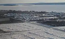
Norman Wells (Slavey language: Tłegǫ́hłı̨ [t͡ɬɛkṍhɬĩ] "where there is oil") is the regional centre for the Sahtu Region of the Northwest Territories (NWT), Canada. The town is situated on the north side of the Mackenzie River and provides a view down the valley of the Franklin and Richardson mountains.[7]
Norman Wells
Tłegǫ́hłı̨ The Wells | |
|---|---|
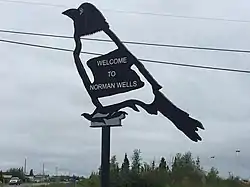 Welcome to Norman Wells | |
| Motto(s): Where Adventures Begin | |
 Norman Wells  Norman Wells | |
| Coordinates: 65°16′52″N 126°49′54″W | |
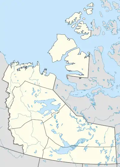
| Country | Canada |
| Territory | Northwest Territories |
| Region | Sahtu |
| Settlement area | Sahtu |
| Constituency | Sahtu |
| Incorporated (town) | 12 April 1992 |
| Government | |
| • Mayor | Frank Pope[1] |
| • Town Manager | Cathy Clarke[1] |
| • MLA | Daniel McNeely |
| Area | |
| • Land | 82.86 km2 (31.99 sq mi) |
| Elevation | 73 m (240 ft) |
| Population (2016)[2] | |
| • Total | 778 |
| • Density | 9.4/km2 (24/sq mi) |
| Time zone | UTC−07:00 (MST) |
| • Summer (DST) | UTC−06:00 (MDT) |
| Canadian Postal code | X0E 0V0 |
| Area code(s) | 867 |
| Telephone exchange | 587 |
| - Living cost | 162.5A |
| - Food price index | 170.6B |
| Website | www.normanwells.com |
| Sources: Department of Municipal and Community Affairs,[3] Prince of Wales Northern Heritage Centre,[4] Canada Flight Supplement[5] ^A 2013 figure based on Edmonton = 100[6] ^B 2015 figure based on Yellowknife = 100[6] | |
Demographics
|
| ||||||||||||||||||||||||||||||||||||||||||||||||||||||||||||||||||||||||
| Sources: NWT Bureau of Statistics (2001–2017)[8] | |||||||||||||||||||||||||||||||||||||||||||||||||||||||||||||||||||||||||
According to the 2016 Census, the town has 778 people, a 7% increase from the last census.[2]
A total of 315 people identified as Indigenous, and of these, 195 were First Nations, 80 were Métis, 15 were Inuit and 20 gave multiple Indigenous responses. The main languages in the town are North Slavey and English. Of the population, 78.1% is 15 and older, with the median age being 32.8, slightly less than the NWT averages of 79.3% and 34.0.[2]
In 2012 the Government of the Northwest Territories reported that the population was 809 with an average yearly growth rate of -0.1 from 2001.[6]
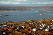
Oil was first seen by Alexander Mackenzie during his exploration of the river in 1789 but it was not until 1911 that an oil bearing formation was discovered. Imperial Oil, a major employer in the town, was established in the area in 1937 with a refinery built in 1939.[7]
During the Second World War, Norman Wells was deemed important as a source of oil for military operations in Alaska and Yukon. The Canol Road and Canol pipeline project was undertaken to enable the piping of oil to Whitehorse, with the flow starting in 1944. Although Norman Wells crude was light and easily flowed at temperatures as low as −62 °C (−80 °F), the line did not work well and was shut down shortly after the war ended. The road, which began at Canol Camp across the river, was abandoned.[7] The Canol Heritage Trail is what remains of the road in the NWT.
The Norman Wells Proven Area Agreement of 1944 is a partnership between Imperial Oil and the federal government (administered by Indigenous and Northern Affairs Canada) that has lasted to this day. The completion of an oil pipeline from Norman Wells to Zama City in 1985 connected to the North American pipeline grid and resulted in increased activity.[9]
First Nations
The Norman Wells Metis, a Métis group which is signatory to the Sahtu Dene and Metis Comprehensive Land Claim Agreement, are currently negotiating self-government powers and recently signed a framework agreement towards a new treaty.
Transportation
Norman Wells is accessible by navigating the Mackenzie River in summer, or by driving over the winter ice road, December to March, that connects with Wrigley and Fort Simpson.[7] The most common method of travel into Norman Wells is by air via the Norman Wells Airport and the town is connected with both Yellowknife and Inuvik.[7] Scheduled flights are provided by Canadian North and North-Wright Airways. Beginning in June 2010, First Air offered a scheduled service into the community. In the summer floatplane access to the town is possible at the Norman Wells Water Aerodrome. During the summer months there are barge services, sealifts to the town by Northern Transportation Company Limited from Hay River and Cooper Barging Services from Fort Simpson.[7] Other aviation companies that have a presence in the community include Canadian Helicopters and Discovery Air.[10]
Services
Services include a three-member Royal Canadian Mounted Police detachment and a community health centre with two nurses with dental visits two or three times a year. There is a branch of the Canadian Imperial Bank of Commerce and two grocery stores including the Northern store and Rampart Rentals along with three hotels and two restaurants. Norman Wells also has a liquor store, currently the only one in the Sahtu Region. Phone service is provided by Northwestel with cable television and Internet access available.[11] Mobile phone services are available through Bell Mobility or Northwestel's Latitude Wireless service, which is now owned by Bell.[12][13] Former member of parliament for the Western Arctic, Ethel Blondin-Andrew, has a consulting service, Mountain Dene Ventures, in the town.[14]
Education
The community is part of the Sahtu Divisional Education Council and they operate, through the Norman Wells District Education Authority, the Mackenzie Mountain School.[15][16] The school, which has an enrollment of 150, provides education from Junior Kindergarten to Grade 12.[17][18] Aurora College has a presence in the community with a community learning centre and a career centre.[12][13]
Climate
Norman Wells has a subarctic climate (Köppen Dfc) with summer lasting for about three months. Although winter temperatures are usually below freezing, every month of the year has seen temperatures above 0 °C (32 °F). Rainfall averages 171.7 mm (6.76 in) and snowfall 161.5 cm (63.58 in). On average, there are 92.9 days, October to April, when the wind chill is below -30, which indicates that frostbite may occur within 10 – 30 minutes. There is an average of 35.9 days, November to April, when the wind chill is below -40, which indicates that frostbite may occur within 5 – 10 minutes.[19][20]
| Climate data for Norman Wells Airport | |||||||||||||
|---|---|---|---|---|---|---|---|---|---|---|---|---|---|
| Month | Jan | Feb | Mar | Apr | May | Jun | Jul | Aug | Sep | Oct | Nov | Dec | Year |
| Record high humidex | 11.8 | 6.3 | 9.4 | 20.0 | 29.1 | 36.2 | 37.2 | 36.0 | 27.2 | 19.8 | 12.2 | 4.8 | 37.2 |
| Record high °C (°F) | 12.4 (54.3) |
7.9 (46.2) |
11.1 (52.0) |
20.0 (68.0) |
31.3 (88.3) |
33.5 (92.3) |
35.0 (95.0) |
32.4 (90.3) |
27.1 (80.8) |
21.0 (69.8) |
13.3 (55.9) |
5.7 (42.3) |
35.0 (95.0) |
| Average high °C (°F) | −22.2 (−8.0) |
−19.5 (−3.1) |
−12.5 (9.5) |
1.0 (33.8) |
12.1 (53.8) |
20.7 (69.3) |
22.5 (72.5) |
19.0 (66.2) |
11.0 (51.8) |
−1.6 (29.1) |
−15.2 (4.6) |
−19.6 (−3.3) |
−0.4 (31.3) |
| Daily mean °C (°F) | −26.1 (−15.0) |
−24.0 (−11.2) |
−18.4 (−1.1) |
−5.1 (22.8) |
6.4 (43.5) |
15.0 (59.0) |
17.1 (62.8) |
13.8 (56.8) |
6.6 (43.9) |
−4.7 (23.5) |
−18.7 (−1.7) |
−23.4 (−10.1) |
−5.1 (22.8) |
| Average low °C (°F) | −29.9 (−21.8) |
−28.4 (−19.1) |
−24.2 (−11.6) |
−11.1 (12.0) |
0.6 (33.1) |
9.3 (48.7) |
11.5 (52.7) |
8.4 (47.1) |
2.0 (35.6) |
−7.7 (18.1) |
−22.2 (−8.0) |
−27.1 (−16.8) |
−9.9 (14.2) |
| Record low °C (°F) | −52.2 (−62.0) |
−54.4 (−65.9) |
−46.1 (−51.0) |
−37.2 (−35.0) |
−17.8 (0.0) |
−2.8 (27.0) |
−1.1 (30.0) |
−6.1 (21.0) |
−15.7 (3.7) |
−31.7 (−25.1) |
−42.8 (−45.0) |
−47.8 (−54.0) |
−54.4 (−65.9) |
| Record low wind chill | −61.7 | −60.2 | −57.5 | −43.8 | −25.1 | −6.9 | 0.0 | −9.6 | −17.7 | −39.9 | −52.4 | −62.4 | −62.4 |
| Average precipitation mm (inches) | 15.6 (0.61) |
14.9 (0.59) |
10.7 (0.42) |
11.1 (0.44) |
19.0 (0.75) |
42.7 (1.68) |
41.8 (1.65) |
41.8 (1.65) |
33.1 (1.30) |
26.7 (1.05) |
18.7 (0.74) |
18.2 (0.72) |
294.4 (11.59) |
| Average rainfall mm (inches) | 0.2 (0.01) |
0.0 (0.0) |
0.1 (0.00) |
1.2 (0.05) |
13.3 (0.52) |
42.4 (1.67) |
41.8 (1.65) |
41.1 (1.62) |
26.7 (1.05) |
4.6 (0.18) |
0.0 (0.0) |
0.2 (0.01) |
171.7 (6.76) |
| Average snowfall cm (inches) | 21.1 (8.3) |
19.9 (7.8) |
14.4 (5.7) |
12.8 (5.0) |
6.4 (2.5) |
0.4 (0.2) |
0.0 (0.0) |
0.7 (0.3) |
6.9 (2.7) |
27.3 (10.7) |
26.0 (10.2) |
25.9 (10.2) |
161.5 (63.6) |
| Average precipitation days (≥ 0.2 mm) | 10.9 | 9.4 | 9.9 | 7.2 | 6.9 | 10.3 | 11.8 | 11.7 | 12.4 | 13.9 | 12.6 | 12.5 | 129.4 |
| Average rainy days (≥ 0.2 mm) | 0.2 | 0.1 | 0.1 | 0.8 | 5.0 | 10.2 | 11.8 | 11.6 | 10.2 | 2.7 | 0.1 | 0.2 | 53.0 |
| Average snowy days (≥ 0.2 cm) | 11.5 | 10.1 | 10.4 | 6.9 | 2.9 | 0.2 | 0.0 | 0.2 | 3.4 | 13.3 | 13.6 | 13.0 | 85.4 |
| Average relative humidity (%) | 65.6 | 61.4 | 54.6 | 52.8 | 47.1 | 46.3 | 50.9 | 56.7 | 62.9 | 76.0 | 72.8 | 67.9 | 59.6 |
| Mean monthly sunshine hours | 31.8 | 75.8 | 166.5 | 220.0 | 331.0 | 300.2 | 273.7 | 232.9 | 139.0 | 56.0 | 15.3 | 9.7 | 1,852 |
| Percent possible sunshine | 20.6 | 32.5 | 45.9 | 48.2 | 56.6 | 45.6 | 43.4 | 45.0 | 35.2 | 18.6 | 8.2 | 8.4 | 34.0 |
| Source: Environment Canada Canadian Climate Normals 1981–2010[20] | |||||||||||||
References
- Phone list
- "Census Profile, 2016 Census Norman Wells, Town [Census subdivision], Northwest Territories and Northwest Territories [Territory]". Statistics Canada. Retrieved 31 August 2018.
- "NWT Communities - Norman Wells". Government of the Northwest Territories: Department of Municipal and Community Affairs. Retrieved 16 January 2014.
- "Northwest Territories Official Community Names and Pronunciation Guide". Prince of Wales Northern Heritage Centre. Yellowknife: Education, Culture and Employment, Government of the Northwest Territories. Archived from the original on 13 January 2016. Retrieved 13 January 2016.
- Canada Flight Supplement. Effective 0901Z 16 July 2020 to 0901Z 10 September 2020.
- Norman Wells - Statistical Profile at the GNWT
- "Norman Wells profile". Legislative Assembly of the Northwest Territories. Archived from the original on 7 February 2012.
- Population Estimates By Community from the GNWT
- https://www.energy.alberta.ca/AU/History/Documents/ArcticEnergyGatewayCanatec.pdf pg23
- Great Slave Heli/Discovery Air/Sahtu Helicopters
- Internet
- Northwestel
- Infrastructure
- Doing Business in Norman Wells
- Sahtu Divisional Education Council
- Community Groups
- Mackenzie Mountain School at the SDEC
- Official school site
- Wind Chill Hazards and Risk of Frostbite Archived 17 December 2005 at the Wayback Machine
- "Norman Wells A *". Canadian Climate Normals 1981–2010. Environment Canada. Climate ID: 2202800. Retrieved 3 December 2020.
External links
| Wikimedia Commons has media related to Norman Wells. |
- NormanWells.com
- 1920 The Discovery of Oil NWT Historical Timeline, Prince of Wales Northern Heritage Centre
| Dehcho Region | |
|---|---|
| Inuvik Region | |
| North Slave Region | |
| Sahtu Region | |
| South Slave Region | |
| |
