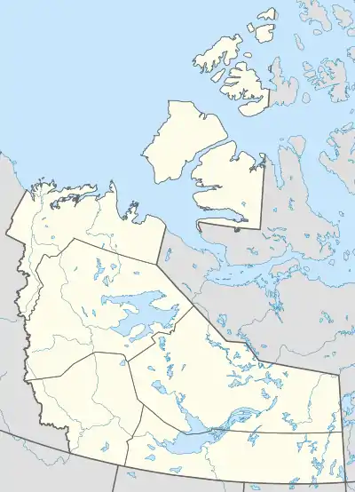
Fort McPherson, Northwest Territories
Fort McPherson (Gwich'in: Teetł'it Zheh [tʰeː.tɬʼɪtʰ ʒɛh], at the head of the waters) is a hamlet located in the Inuvik Region of the Northwest Territories, Canada. It is located on the east bank of the Peel River and is 121 km (75 mi) south of Inuvik on the Dempster Highway.
Fort McPherson
Teetł'it Zheh The heart of the Gwichʼin | |
|---|---|
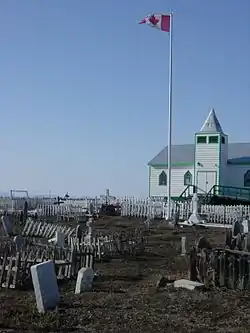 A wooden church in Fort McPherson, NWT | |
| Motto(s): "Take what you need" | |
 Fort McPherson  Fort McPherson | |
| Coordinates: 67°26′07″N 134°52′55″W | |
| Country | Canada |
| Territory | Northwest Territories |
| Region | Inuvik Region |
| Constituency | Mackenzie Delta |
| Census division | Region 1 |
| Hamlet | 1 November 1986 |
| Government | |
| • May | Elizabeth Vittrekwa |
| • Senior Administrative Officer | Morag Macpherson |
| • MLA | Frederick Blake Jr. |
| Area | |
| • Land | 53.39 km2 (20.61 sq mi) |
| Elevation | 43 m (141 ft) |
| Population (2016)[1] | |
| • Total | 700 |
| • Density | 13.1/km2 (34/sq mi) |
| Time zone | UTC−07:00 (MST) |
| • Summer (DST) | UTC−06:00 (MDT) |
| Canadian Postal code | X0E 0J0 |
| Area code(s) | 867 |
| Telephone exchange | 952 |
| - Living cost | 162.5A |
| - Food price index | 157.7B |
| Website | www.fortmcpherson.ca |
| Sources: Department of Municipal and Community Affairs,[2] Prince of Wales Northern Heritage Centre,[3] Canada Flight Supplement[4] ^A 209 figure based on Edmonton = 100[5] ^B 2015 figure based on Yellowknife = 100[5] | |
| Official name | Fort McPherson National Historic Site of Canada |
| Designated | 1969 |
The First Nations people who make up the majority are Gwich'in (Teetł'it Gwich'in) and the two principal languages spoken are Gwichʼin and English.[6] Originally the site of a Hudson's Bay Company post the community was named for Murdoch McPherson.
Most people have vehicles and regularly make trips to either Inuvik, or Whitehorse, Yukon.
History
Fort McPherson was the starting point of Francis Joseph Fitzgerald's famous tragic journey of "The Lost Patrol". All four men on the Patrol, including Fitzgerald, were buried at Fort McPherson on 28 March 1911. In 1938, the graves were cemented over into one large tomb (to the right of the flag pole in above image), with cement posts at the four corners connected by a chain. In the centre is a memorial to the Royal Northwest Mounted Police Patrol of 1910.
National Historic Site
In 1969, the area comprising the boundaries of the community of Fort McPherson, as it was mapped in 1898, was designated a National Historic Site of Canada, in recognition of the fact that the site had served as the principal Hudson's Bay Company trading post in the MacKenzie Delta region for over 50 years, and had been the first North-West Mounted Police post in the Western Arctic.[7]
Transportation
Fort McPherson is accessible by road all year from Dawson City and Whitehorse, Yukon, with the exception of spring break-up and fall freeze-up on the Peel River. The community also has access to Inuvik via the Dempster Highway and crosses the Mackenzie River at Tsiigehtchic.
There is also a small airport at Fort McPherson, Fort McPherson Airport, that has seasonal flights to Inuvik (Mike Zubko) Airport on Aklak Air when the road across the Peel is closed.[8] The former Fort McPherson Water Aerodrome was listed as closed in the 15 March 2007 Canada Flight Supplement.[4]
Demographics
Population is 700 according to the 2016 Census, an 11.6% decrease from the 2011 Census count of 792. In the 2016 Census 695 people identified as Indigenous, 610 as First Nations, 15 as Métis, 20 as Inuit or Inuvialuit, 10 giving multiple or other aboriginal responses and 40 Non-Aboriginal.[1] In 2017 the Government of the Northwest Territories reported that the population was 776 with an average yearly growth rate of -0.4% from 2007.[5]
|
| ||||||||||||||||||||||||||||||||||||||||||||||||||||||||||||||||||||||||
| Sources: NWT Bureau of Statistics (2001 - 2017)[9] | |||||||||||||||||||||||||||||||||||||||||||||||||||||||||||||||||||||||||
Climate
Fort McPherson experiences a subarctic climate (Köppen climate classification Dfc). The highest temperature ever recorded in Fort McPherson was 33.3 °C (92 °F) on 7 August 1919 and 20 July 2001.[10][11] The coldest temperature ever recorded was −55.6 °C (−68 °F) on 14 January 1894.[12]
| Climate data for Fort McPherson Airport, 1981–2010 normals, extremes 1892–present[lower-alpha 1] | |||||||||||||
|---|---|---|---|---|---|---|---|---|---|---|---|---|---|
| Month | Jan | Feb | Mar | Apr | May | Jun | Jul | Aug | Sep | Oct | Nov | Dec | Year |
| Record high °C (°F) | 8.9 (48.0) |
10.0 (50.0) |
10.6 (51.1) |
16.7 (62.1) |
29.5 (85.1) |
32.0 (89.6) |
33.3 (91.9) |
33.3 (91.9) |
27.2 (81.0) |
24.1 (75.4) |
10.0 (50.0) |
9.0 (48.2) |
33.3 (91.9) |
| Average high °C (°F) | −23.8 (−10.8) |
−20.8 (−5.4) |
−14.9 (5.2) |
−4.0 (24.8) |
6.9 (44.4) |
18.5 (65.3) |
20.2 (68.4) |
16.4 (61.5) |
8.4 (47.1) |
−4.0 (24.8) |
−17.2 (1.0) |
−20.8 (−5.4) |
−2.9 (26.8) |
| Daily mean °C (°F) | −27.5 (−17.5) |
−24.9 (−12.8) |
−20.3 (−4.5) |
−9.9 (14.2) |
2.1 (35.8) |
13.0 (55.4) |
15.2 (59.4) |
11.8 (53.2) |
4.6 (40.3) |
−7.0 (19.4) |
−20.5 (−4.9) |
−24.4 (−11.9) |
−7.3 (18.9) |
| Average low °C (°F) | −31.1 (−24.0) |
−29.0 (−20.2) |
−25.7 (−14.3) |
−15.7 (3.7) |
−2.7 (27.1) |
7.5 (45.5) |
10.2 (50.4) |
7.2 (45.0) |
0.8 (33.4) |
−9.9 (14.2) |
−23.8 (−10.8) |
−28.1 (−18.6) |
−11.7 (10.9) |
| Record low °C (°F) | −55.6 (−68.1) |
−55.0 (−67.0) |
−48.9 (−56.0) |
−44.4 (−47.9) |
−25.6 (−14.1) |
−6.7 (19.9) |
−1.1 (30.0) |
−6.7 (19.9) |
−19.5 (−3.1) |
−37.5 (−35.5) |
−46.7 (−52.1) |
−50.6 (−59.1) |
−55.6 (−68.1) |
| Average precipitation mm (inches) | 14.9 (0.59) |
14.8 (0.58) |
12.7 (0.50) |
10.9 (0.43) |
17.2 (0.68) |
25.5 (1.00) |
46.4 (1.83) |
39.4 (1.55) |
33.1 (1.30) |
37.0 (1.46) |
29.0 (1.14) |
17.0 (0.67) |
297.7 (11.72) |
| Average rainfall mm (inches) | 0.0 (0.0) |
0.0 (0.0) |
0.0 (0.0) |
0.3 (0.01) |
8.2 (0.32) |
25.1 (0.99) |
46.4 (1.83) |
39.1 (1.54) |
25.7 (1.01) |
1.2 (0.05) |
0.0 (0.0) |
0.0 (0.0) |
145.9 (5.74) |
| Average snowfall cm (inches) | 14.9 (5.9) |
14.8 (5.8) |
12.7 (5.0) |
10.6 (4.2) |
9.0 (3.5) |
0.4 (0.2) |
0.0 (0.0) |
0.3 (0.1) |
7.4 (2.9) |
36.4 (14.3) |
29.0 (11.4) |
17.0 (6.7) |
152.5 (60.0) |
| Average precipitation days (≥ 0.2 mm) | 6.4 | 5.1 | 6.0 | 4.1 | 5.2 | 7.0 | 9.9 | 11.3 | 11.0 | 11.8 | 9.9 | 6.8 | 94.3 |
| Average rainy days (≥ 0.2 mm) | 0.0 | 0.0 | 0.0 | 0.2 | 2.5 | 6.9 | 9.9 | 11.3 | 8.8 | 0.8 | 0.0 | 0.1 | 40.4 |
| Average snowy days (≥ 0.2 cm) | 6.4 | 5.1 | 6.0 | 4.0 | 2.9 | 0.2 | 0.0 | 0.2 | 2.6 | 11.2 | 9.9 | 6.7 | 55.1 |
| Source: Environment Canada[11][12][13][14][15][16][17][18][10][19][20][21][22][23][24][25][26][27] | |||||||||||||
References
- Census Profile, 2016 Census Fort McPherson, Hamlet (Census subdivision), Northwest Territories and Northwest Territories (Territory)
- "NWT Communities - Fort McPherson". Government of the Northwest Territories: Department of Municipal and Community Affairs. Retrieved 13 January 2014.
- "Northwest Territories Official Community Names and Pronunciation Guide". Prince of Wales Northern Heritage Centre. Yellowknife: Education, Culture and Employment, Government of the Northwest Territories. Archived from the original on 13 January 2016. Retrieved 13 January 2016.
- Canada Flight Supplement. Effective 0901Z 16 July 2020 to 0901Z 10 September 2020.
- Fort McPherson - Statistical Profile
- Fort McPherson - A Brief History
- Fort McPherson National Historic Site of Canada. Canadian Register of Historic Places. Retrieved 4 October 2013.
- "Flight Schedule" (PDF). Archived from the original (PDF) on 14 January 2014. Retrieved 13 January 2014.
- Population Estimates By Community from the GNWT
- "Daily Data Report for August 1919". Canadian Climate Data. Environment Canada. Climate ID: 2201600. Retrieved 1 July 2016.
- "Fort McPherson A". Canadian Climate Normals 1981–2010. Environment Canada. Climate ID: 2201601. Retrieved 1 July 2016.
- "Daily Data Report for January 1894". Canadian Climate Data. Environment Canada. Climate ID: 2201600. Retrieved 1 July 2016.
- "Daily Data Report for March 1897". Canadian Climate Data. Environment Canada. Climate ID: 2201600. Retrieved 1 July 2016.
- "Daily Data Report for April 1899". Canadian Climate Data. Environment Canada. Climate ID: 2201600. Retrieved 1 July 2016.
- "Daily Data Report for February 1911". Canadian Climate Data. Environment Canada. Climate ID: 2201600. Retrieved 1 July 2016.
- "Daily Data Report for January 1916". Canadian Climate Data. Environment Canada. Climate ID: 2201600. Retrieved 1 July 2016.
- "Daily Data Report for June 1918". Canadian Climate Data. Environment Canada. Climate ID: 2201600. Retrieved 1 July 2016.
- "Daily Data Report for February 1918". Canadian Climate Data. Environment Canada. Climate ID: 2201600. Retrieved 1 July 2016.
- "Daily Data Report for March 1926". Canadian Climate Data. Environment Canada. Climate ID: 2201600. Retrieved 1 July 2016.
- "Daily Data Report for November 1927". Canadian Climate Data. Environment Canada. Climate ID: 2201600. Retrieved 1 July 2016.
- "Daily Data Report for August 1928". Canadian Climate Data. Environment Canada. Climate ID: 2201600. Retrieved 1 July 2016.
- "Daily Data Report for May 1935". Canadian Climate Data. Environment Canada. Climate ID: 2201600. Retrieved 1 July 2016.
- "Daily Data Report for December 1937". Canadian Climate Data. Environment Canada. Climate ID: 2201600. Retrieved 1 July 2016.
- "Daily Data Report for September 1940". Canadian Climate Data. Environment Canada. Climate ID: 2201600. Retrieved 1 July 2016.
- "Daily Data Report for April 1960". Canadian Climate Data. Environment Canada. Climate ID: 2201600. Retrieved 1 July 2016.
- "Daily Data Report for February 1968". Canadian Climate Data. Environment Canada. Climate ID: 2201600. Retrieved 1 July 2016.
- "Daily Data Report for May 2010". Canadian Climate Data. Environment Canada. Climate ID: 2201601. Retrieved 1 July 2016.
- Climate data was recorded at Fort McPherson from October 1892 to June 1977 and at Fort McPherson Airport from August 1981 to present.
Further reading
- Carefoot, E. I., and N. A. Lawrence. Utility Study Settlement of Ft. McPherson for Department of Public Works, Government of the Northwest Territories. Edmonton: Associated Engineering Services, 1972.
- Gallupe, Scott. Husky Lake, Fort McPherson Area Historic Hydrocarbon Exploration Investigation June 29, 1992. Inuvik, NT: Northern Affairs Program, Indian and Northern Affairs Canada, 1992.
- Kakfwi, Stephen. Literacy Program Funding, Fort McPherson. Yellowknife?, N.W.T.: Northwest Territories, Executive Council, 1991.
- Manitoba Free Press. Pemmican Made at Fort McPherson, a Hudson's Bay Company's Post Sixty-Five Miles Within the Arctic Circle and Two Thousand Nine Hundred and Seventy-Eight Miles Northwest of Winnipeg A Christmas Present from the Manitoba Free Press. Winnipeg: [s.n.], 1902. ISBN 0-665-78324-8
- Northern Engineering Services Company, and Canadian Arctic Gas Study Limited. Report on All-Weather Road from Prudhoe Bay, Alaska to Fort McPherson, N.W.T. [Canada?]: Northern Engineering Services, 1972.
- Northwest Territories, and Jane Gilmartin Gilchrist Collection (Newberry Library). Gwich'in Alphabet Posters Fort McPherson Dialect. [Fort McPherson]: Northwest Territories, Dept. of Education, Programs and Evaluation Branch, 1981.
- Ripley, Klohn & Leonoff International Limited. Community Granular Materials Inventory Fort McPherson, N.W.T. [s.l.]: Dept. of Indian Affairs and Northern Development, 1972.
External links
| Wikimedia Commons has media related to Fort McPherson, Northwest Territories. |
| Dehcho Region | |
|---|---|
| Inuvik Region | |
| North Slave Region | |
| Sahtu Region | |
| South Slave Region | |
| |
| Provinces | |
|---|---|
| Territories | |
| Other countries | |
| |
| National parks | |
|---|---|
| National historic sites |
|
| Territorial parks |
|
| Other | |
| |