Tulita
Tulita, which in Slavey means "where the rivers or waters meet," is a hamlet in the Sahtu Region of the Northwest Territories, Canada. It was formerly known as Fort Norman, until 1 January 1996. It is located at the junction of the Great Bear River and the Mackenzie River; the Bear originates at Great Bear Lake adjacent to Deline.
Tulita
Tulít’a | |
|---|---|
 | |
 Tulita  Tulita | |
| Coordinates: 64°54′01″N 125°34′39″W | |
| Country | Canada |
| Territory | Northwest Territories |
| Region | Sahtu |
| Settlement area | Sahtu |
| Constituency | Sahtu |
| Hamlet | 1 April 1984 |
| Government | |
| • Mayor | Rocky Norwegian Sr. |
| • Senior Administrative Officer | Bradley Menacho |
| • MLA | Daniel McNeely |
| Area | |
| • Land | 52.12 km2 (20.12 sq mi) |
| Elevation | 101 m (331 ft) |
| Population (2011)[1] | |
| • Total | 477 |
| • Density | 9.2/km2 (24/sq mi) |
| Time zone | UTC−07:00 (MST) |
| • Summer (DST) | UTC−06:00 (MDT) |
| Canadian Postal code | X0E 0K0 |
| Area code(s) | 867 |
| Telephone exchange | 588 |
| - Living cost | 177.5A |
| - Food price index | 165.8B |
| Sources: Department of Municipal and Community Affairs,[2] Prince of Wales Northern Heritage Centre,[3] Tulita profile at the Legislative Assembly[4] br>Canada Flight Supplement[5] ^A 2013 figure based on Edmonton = 100[6] ^B 2015 figure based on Yellowknife = 100[6] | |
Tulita is in an area that is forested and well south of the tree line. Permafrost underlays the area, more or less continuous in distribution. Tulita is surrounded by mountains, the latter renowned for Dall sheep, and faces the Mackenzie Mountains to the west, which has mountain goats.
History
Fort Norman originated as a Hudson's Bay Company trading post in the 19th century and has occupied a number of geographical locations prior to the settling of the modern community. A post by the name of Fort Norman occupied several locations, on the Mackenzie River, on the islands within it, on Bear River, and on the shore of Great Bear Lake near the present location of Deline. Who the name 'Norman' commemorates is unclear, but it may have been either Alexander Norman McLeod or Archibald Norman McLeod, both of whom were prominent in the northwest in the early 19th century.[7]
Between 1863 and 1869, Fort Norman was located on Great Bear Lake, a short distance west of what later became Deline (Fort Franklin), and was an HBC post commanded by Nichol Taylor. Roman Catholic missionary Emile Petitot operated a small mission here during that period. In 1869, Nichol Taylor moved Fort Norman to its present position at the confluence of the Mackenzie and Bear Rivers.[8]
Fort Norman rose to importance during the 1920s oil staking rush along the Mackenzie River, 50 km (31 mi) downstream of the community, where oil was developed and marketed at what became known as Norman Wells.[9] It has also become a permanent settlement for predominately Sahtu Dene people on whose traditional land the original trading post was built. In 1996, the name of Fort Norman was officially changed to Tulita, which translates in Dene to "where the rivers or waters meet."
Demographics
The population in the 2016 Census was 477, a decrease of 0.2% from the 2011 Census The majority of the population is Indigenous being First Nations and Métis. The main languages are North Slavey and English with some Dene.[1][4]
In 2017 the Government of the Northwest Territories reported that the population was 497 with an average yearly growth rate of -0.5% from 2007.[6]
|
| ||||||||||||||||||||||||||||||||||||||||||||||||||||||||||||||||||||||||
| Sources: NWT Bureau of Statistics (2001–2017)[10] | |||||||||||||||||||||||||||||||||||||||||||||||||||||||||||||||||||||||||
Transport and tourism
Tulita may be reached via air year-round, and is served by Tulita Airport; Norman Wells is the regional centre and the site of origin of the majority of flights in. A winter road links Tulita to Wrigley and thence the Mackenzie Highway, and is only open in mid- to late winter. Summer access is available by barge or by canoe, from Hay River along the Mackenzie River. The NWT government is seeking federal funding to extend the Mackenzie Highway from Wrigley through Tulita to Tsiigehtchic.
Amenities consist of a hotel, Northern Store, Royal Canadian Mounted Police detachment, and a nursing station.[11] Chief Albert Wright School teaches grades K-12 while the hamlet has a library, arena, recreation hall, and fitness centre.[12]
First Nations
The Dene First Nations people of Tulita are represented by the Tulita Dene First Nation, a band government operating within the community. The TDFN is a member of the Sahtu Dene Council, joining the Behdzi Ahda' First Nation, Délı̨nę First Nation, and Fort Good Hope First Nation.
Treaty Indians from the community are party to the Sahtu Agreement, which gives them shared title to 41,437 square kilometers of land in the Sahtu Region. Under the Sahtu Agreement, self-government negotiations are ongoing in all five of the region's communities, but as of 2019 only Délı̨nę has successfully reached a Final Agreement.[13]
Notable people
- Leslie Nielsen lived here while his father was stationed with the Royal Canadian Mounted Police.
Gallery
 Tulita with the Mackenzie River
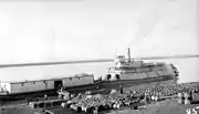 Sternwheeler Distributor and barge at Fort Norman, 1936
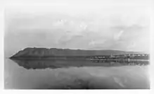 Fort Norman and Bear Rock
.jpg.webp) The Imperial Oil Company's expedition to the Fort Norman oil fields, 1921
The Imperial Oil Company's expedition to the Fort Norman oil fields, 1921.jpg.webp) The Imperial Oil Company's expedition to the Fort Norman oil fields, 1921
The Imperial Oil Company's expedition to the Fort Norman oil fields, 1921
Climate
Tulita experiences a subarctic climate (Koppen: Dfc) with generally mild to warm summers and cold winters with highs often well-below zero. Peak snowfall occurs in the months of October and November, while rainfall is limited to the warmer months.
| Climate data for Tulita Airport | |||||||||||||
|---|---|---|---|---|---|---|---|---|---|---|---|---|---|
| Month | Jan | Feb | Mar | Apr | May | Jun | Jul | Aug | Sep | Oct | Nov | Dec | Year |
| Record high humidex | 3.9 | 4.8 | 6.7 | 19.7 | 29.0 | 34.7 | 37.0 | 44.8 | 26.5 | 20.1 | 4.0 | −1.2 | 44.8 |
| Record high °C (°F) | 5.6 (42.1) |
8.3 (46.9) |
15.0 (59.0) |
20.6 (69.1) |
31.7 (89.1) |
34.4 (93.9) |
35.0 (95.0) |
33.3 (91.9) |
28.5 (83.3) |
22.8 (73.0) |
8.3 (46.9) |
3.0 (37.4) |
35.0 (95.0) |
| Average high °C (°F) | −21.7 (−7.1) |
−19.1 (−2.4) |
−11.5 (11.3) |
0.7 (33.3) |
12.4 (54.3) |
20.9 (69.6) |
22.7 (72.9) |
19.2 (66.6) |
10.3 (50.5) |
−2.2 (28.0) |
−14.5 (5.9) |
−18.6 (−1.5) |
−0.1 (31.8) |
| Daily mean °C (°F) | −25.2 (−13.4) |
−23.4 (−10.1) |
−17.3 (0.9) |
−5.3 (22.5) |
6.6 (43.9) |
14.9 (58.8) |
17.1 (62.8) |
14.1 (57.4) |
6.2 (43.2) |
−5.0 (23.0) |
−17.8 (0.0) |
−22.3 (−8.1) |
−4.8 (23.4) |
| Average low °C (°F) | −28.7 (−19.7) |
−27.6 (−17.7) |
−23.0 (−9.4) |
−11.3 (11.7) |
0.7 (33.3) |
8.9 (48.0) |
11.5 (52.7) |
9.0 (48.2) |
2.1 (35.8) |
−7.8 (18.0) |
−20.7 (−5.3) |
−25.9 (−14.6) |
−9.4 (15.1) |
| Record low °C (°F) | −53.9 (−65.0) |
−54.4 (−65.9) |
−50.0 (−58.0) |
−40.0 (−40.0) |
−23.9 (−11.0) |
−5.6 (21.9) |
−3.3 (26.1) |
−7.8 (18.0) |
−15.6 (3.9) |
−32.8 (−27.0) |
−49.0 (−56.2) |
−53.3 (−63.9) |
−54.4 (−65.9) |
| Record low wind chill | −56.5 | −57.1 | −55.6 | −36.3 | −24.0 | −5.9 | 0.0 | 0.0 | −12.3 | −35.4 | −48.3 | −55.2 | −57.1 |
| Average precipitation mm (inches) | 14.8 (0.58) |
11.5 (0.45) |
8.7 (0.34) |
9.1 (0.36) |
13.4 (0.53) |
36.0 (1.42) |
44.2 (1.74) |
46.9 (1.85) |
38.9 (1.53) |
32.8 (1.29) |
21.8 (0.86) |
15.0 (0.59) |
293.0 (11.54) |
| Average rainfall mm (inches) | 0.0 (0.0) |
0.0 (0.0) |
0.0 (0.0) |
0.7 (0.03) |
9.8 (0.39) |
35.9 (1.41) |
44.2 (1.74) |
46.9 (1.85) |
36.5 (1.44) |
2.7 (0.11) |
0.0 (0.0) |
0.0 (0.0) |
176.8 (6.96) |
| Average snowfall cm (inches) | 14.8 (5.8) |
11.5 (4.5) |
8.7 (3.4) |
8.5 (3.3) |
3.7 (1.5) |
0.1 (0.0) |
0.0 (0.0) |
0.0 (0.0) |
2.4 (0.9) |
30.1 (11.9) |
22.2 (8.7) |
15.0 (5.9) |
116.7 (45.9) |
| Average precipitation days (≥ 0.2 mm) | 7.1 | 5.7 | 5.8 | 3.9 | 4.7 | 7.6 | 9.1 | 9.1 | 8.6 | 9.4 | 8.9 | 8.3 | 88.1 |
| Average rainy days (≥ 0.2 mm) | 0.0 | 0.0 | 0.0 | 0.3 | 3.5 | 7.6 | 9.1 | 9.1 | 7.6 | 1.5 | 0.1 | 0.0 | 38.7 |
| Average snowy days (≥ 0.2 cm) | 7.1 | 5.7 | 5.8 | 3.7 | 1.2 | 0.1 | 0.0 | 0.0 | 0.9 | 8.1 | 8.9 | 8.3 | 49.7 |
| Source: Environment Canada Canadian Climate Normals 1981–2010[14] | |||||||||||||
References
- Census Profile, 2016 Census Tulita, Hamlet (Census subdivision), Northwest Territories and Northwest Territories (Territory)]
- "NWT Communities - Tulita". Government of the Northwest Territories: Department of Municipal and Community Affairs. Retrieved 20 January 2014.
- "Northwest Territories Official Community Names and Pronunciation Guide". Prince of Wales Northern Heritage Centre. Yellowknife: Education, Culture and Employment, Government of the Northwest Territories. Archived from the original on 13 January 2016. Retrieved 13 January 2016.
- "Legislative Assembly of the Northwest Territories, Tuktoyaktuk profile". Assembly.gov.nt.ca. Archived from the original on 21 September 2013.
- Canada Flight Supplement. Effective 0901Z 16 July 2020 to 0901Z 10 September 2020.
- Tulita - Statistical Profile at the GNWT
- Fort Norman: History of H.B.C. Post on the Mackenzie River. The Beaver, July 1922.
- Petitot, Emile Travels Around Great Slave and Great Bear Lakes, 1862-1882. Toronto: The Champlain Society, 2005.
- The Story of the Fort Norman Oil Well, The Edmonton Bulletin, 5 March 1921
- Population Estimates By Community from the GNWT
- Tulita Infrastructure Profile
- "Tulita Land Corporation". tulitalandcorp. Retrieved 4 January 2016.
- "First Nation Detail". Indigenous and Northern Affairs Canada. Government of Canada. Retrieved 22 August 2019.
- "Tulita A" (CSV (3069 KB)). Canadian Climate Normals 1981–2010. Environment Canada. Climate ID: 2201700. Retrieved 9 January 2014.
| Wikimedia Commons has media related to Tulita. |
| Dehcho Region | |
|---|---|
| Inuvik Region | |
| North Slave Region | |
| Sahtu Region | |
| South Slave Region | |
| |