Oeiras, Portugal
Oeiras (Portuguese pronunciation: [oˈɐjɾɐʃ] (![]() listen)) is a municipality in the western part of Lisbon metropolitan area, a subregion of Greater Lisbon, in continental Portugal. It is part of the urban agglomeration of Lisbon, 16 km from the capital. The population in 2011 was 172,120[1] living in an area of 45.88 km2,[2] making the municipality the fifth-most densely populated in Portugal.
listen)) is a municipality in the western part of Lisbon metropolitan area, a subregion of Greater Lisbon, in continental Portugal. It is part of the urban agglomeration of Lisbon, 16 km from the capital. The population in 2011 was 172,120[1] living in an area of 45.88 km2,[2] making the municipality the fifth-most densely populated in Portugal.
Oeiras | |
|---|---|
.jpg.webp) .jpg.webp) _(cropped).jpg.webp) _(cropped).jpg.webp) _(cropped).jpg.webp) _(cropped).jpg.webp) 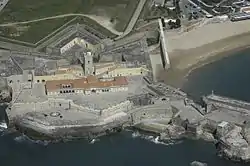 Top: Porto Salvo; Paço de Arcos Beach; middle: Palace of the Marquis of Pombal; Fort of São Lourenço do Bugio; Monsanto Tower; bottom: Royal Gardens of Caxias; São Julião da Barra Fortress | |
 Flag  Coat of arms | |
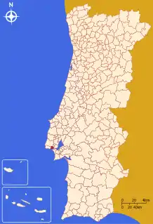 | |
| Coordinates: 38°41′N 9°19′W | |
| Country | |
| Region | Lisboa |
| Metropolitan area | Lisbon |
| District | Lisbon |
| Parishes | 5 |
| Government | |
| • President | Isaltino Morais (Independent) |
| Area | |
| • Total | 45.88 km2 (17.71 sq mi) |
| Lowest elevation | 0 m (0 ft) |
| Population (2011) | |
| • Total | 172,120 |
| • Density | 3,800/km2 (9,700/sq mi) |
| Time zone | UTC±00:00 (WET) |
| • Summer (DST) | UTC+01:00 (WEST) |
| Postal code | 2784 |
| Area code | 214 |
| Patron | Nossa Senhora da Purificação |
| Website | www |
Oeiras is an important economic hub, being one of the most highly developed municipalities of Portugal and Europe. It has the highest GDP per capita in the country, being also the second highest municipality (immediately after Lisbon) in terms of purchasing power as well as the second one collecting taxes in the country. These economic indicators also reflect the education level of the inhabitants, as Oeiras is the municipality with the highest concentration of population with higher education in the country. It also has the lowest unemployment rate in the Lisbon area.
History
The mild climate, access to water, quality of its soils and geographically advantageous location at the mouth of the Tagus River attracted early settlement to this region. The rugged hilltops of the interior conditioned cultivation and allowed the settlement of several small agricultural castros within the region's limits, such as Castro of Leceia (which was classified in 1963 as a property of public interest). This archaeological site is a witness to the early settlements and defensive structures that developed during the Chalcolithic period, although Paleolithic camps such as Gruta da Ponte da Laje are indicative of earlier settlements.
Remnants of the Roman occupation of the Iberian peninsula are evident in many places throughout the municipality, including mosaics, specifically along the Rua das Alcássimas, and a Roman bridge. The later Arab conquest left behind several toponymic markers, including Arab/Moorish place names such as Alcássimas, Algés, Alpendroado and Quinta da Moura.
The settlement of Oeiras dates back to 1208, when the area was colonized by Christian tribes from the northern Portugal, moving south into warmer agricultural lands.
Kingdom era
At the beginning of the Age of Discoveries, Oeiras became the industrial and commercial warehouse of Lisbon. The development of the Gunpowder Factory (Portuguese: Fábrica da Pólvora) in Barcarena was therefore important in the expansion of the Portuguese dominions of the Orient, in addition to the aggregate extraction and calcium oxide furnaces in Paço de Arcos. These industries were supported and guarded by the construction of several fortifications along a maritime defensive line that ringed the southern coast to Lisbon and that controlled navigation in the Tagus estuary from the 16th to 18th centuries. This perimeter included the Fort of São Lourenço da Cabeça Seca (also known as the Lighthouse or Tower of Bugio), rising from a tiny islet in the middle of the Tagus River, as well as the Fort of São Julião da Barra, both examples of Renaissance military architecture.
The municipality was founded in 1759 by the Marquis of Pombal on an area granted as a reward by King Joseph I to his minister for his efforts in rebuilding Lisbon's historical downtown (Portuguese: Baixa) after the 1755 Lisbon earthquake. A royal charter, dated 7 June 1759, gave jurisdiction over the lands within Oeiras to the King's loyal minister, who became the first Count of Oeiras. A month later, the small village was elevated to the status of town, and then gained municipal status on 13 June 1759. Although Oeiras had a history of earlier settlement, it was during the reign of Joseph I that economic and social development, conditioned by the influence of the King's Minister, who promoted innovation and supported local economic activities, began to flourish.
In 1770, the first agricultural and industrial fair was established in Oeiras, representing a unique national event that also contributed to the creation of fishing shelters and a new customhouse and factory, among other projects. One of the principal developments was the construction of the estate of the Marquess of Pombal, which today exists in its original form, with garden, palace and agricultural dependencies, such as the wine cellar, barn and other buildings, today housing the national institutions responsible for bio-science.
In 1894, the municipality was abolished, but it was reestablished four years later on 13 January 1898. It was reconstituted without Carcavelos, which was annexed to Cascais, while gaining the civil parish of Benfica. In the late 17th and early 18th centuries, several estates and palaces began to be constructed in order to explore agricultural production, principally cereals and vineyards, which supported the growing markets of Lisbon. However, this activity began to decline by the 19th century and was replaced by new industry, supported by the Lisbon-Cascais railway link, first inaugurated in 1889. Large factories began to locate in the municipality, among them the Fábrica do Papel, the Fundição de Oeiras, a Lusalite and Fermentos Holandeses.
20th century
In the late 19th and early 20th centuries, the growth of leisure activities along the coast transformed Oeiras, which became a privileged location for the Portuguese elite. By the beginning of the 20th century, many of the beaches in Oeiras were already occupied by the higher social classes, who travelled to the municipality for medical reasons (believing the air and beach-waters were therapeutic). The construction of National Roadway 6 (EN6) would later link Lisboa to Cascais, permitting new travellers to experience the area, resulting in an influx of new residents that expanded the urban centres, giving rise to beach "chalets" and summer cottages. Simultaneously, the concentration of economic activities in Lisbon and surrounding urban municipalities meant that Oeiras had direct access to the capital.
After 1940–50, the municipality began to function as a suburb and bedroom community, attracting more residential growth along the coast. This culminated in the 1970s with the appearance of illegal urban settlements, squatters and barrios. Until the 1980s, the municipality was dependent on the much larger urban centre for development.
By the end of the 1980s, however, Oeiras began to constitute its own economic pole in the Lisbon metropolitan area, concentrating its development on tertiary activities linked to science, investigation, information technology and communications. At the end of the 20th century, the municipality became known for its high standard of living, leaving behind its image as a suburb of Lisbon and assuming an important position as a centre associated with new technologies (with the establishment of various technology parks, such as Taguspark and LagoasPark) and service industries. The elevated standard of living and work allowed the region to obtain several awards, including the Melhor Concelho para Trabalhar ('Best Municipality to Work'), Município de excelência ('Municipal Excellence' Award), European Enterprise Award and the ECOXXI Award.
Geography

The municipality is located along the northern margin and mouth of the Tagus River, across from the municipality of Almada, surrounded by the municipalities of Lisbon (east), Sintra (north), Amadora (northeast) and Cascais (west).
Administratively, the municipality is divided into five civil parishes (freguesias):[3]
- Algés, Linda-a-Velha e Cruz Quebrada-Dafundo
- Barcarena
- Carnaxide e Queijas
- Oeiras e São Julião da Barra, Paço de Arcos e Caxias
- Porto Salvo
Along the 10 km coastline, where the Tagus River meets the ocean, several natural coves were at the origin of its beaches:
- Praia da Torre
- Praia de Santo Amaro de Oeiras
- Praia de Paço de Arcos
- Praia de Caxias
Two major green areas spread over Oeiras municipality: the Estação Agronómica Nacional and the Jamor sports complex.
Demographics
| Year | Pop. | ±% |
|---|---|---|
| 1801 | 6,069 | — |
| 1849 | 5,072 | −16.4% |
| 1900 | 10,447 | +106.0% |
| 1930 | 29,440 | +181.8% |
| 1960 | 94,255 | +220.2% |
| 1981 | 149,328 | +58.4% |
| 1991 | 151,342 | +1.3% |
| 2001 | 162,128 | +7.1% |
| 2011 | 172,120 | +6.2% |
Oeiras municipality had a population of 172,120 at the 2011 Census, remaining the nation's 11th most populous municipality and the 5th greatest in terms of population density.
The major expansion in the municipality's demographics, like those of the other municipalities that circle Lisbon, occurred in the second half of the 20th century. Realizing this growth, and understanding that there was a need to control urban sprawl, in 1948 the Plano de Urbanização da Costa do Sol ('Sun Coast Urbanization Plan') was adopted to manage this activities in the northern margin of the Tagus. This remained active until 1994, when the first Plano Director Municipal ('Municipal Plan') was adopted.
Demographically, the population is divided into 52.6% women to 47.4% men, with the majority of its resident population in the cohort between 25 and 64 years of age (approximately 92,978 inhabitants). Rounding out these numbers, there are 24,153 seniors over the age of 65 and 22,685 residents less than 14 years of age.[4] Oeiras has the highest concentration of bachelor's and PhD degrees in the country, as well as the highest percentage of graduates in the country: 26%.
| Number of Inhabitants by age group | ||||||||||||
|---|---|---|---|---|---|---|---|---|---|---|---|---|
| 1900 | 1911 | 1920 | 1930 | 1940 | 1950 | 1960 | 1970 | 1981 | 1991 | 2001 | 2011 | |
| 0–14 years | 3,170 | 5,373 | 5,352 | 7,870 | 9,096 | 11,404 | 22,855 | 46,865 | 38,784 | 27,728 | 22,685 | 26,559 |
| 15–24 years | 2,082 | 3,473 | 4,123 | 6,405 | 7,313 | 10,206 | 14,679 | 26,285 | 20,635 | 24,932 | 22,312 | 16,533 |
| 25–64 years | 4,936 | 7,625 | 8,335 | 13,748 | 19,744 | 28,262 | 51,388 | 96,155 | 79,278 | 82,855 | 92,978 | 96,059 |
| ≤ 65 years | 559 | 805 | 847 | 1,340 | 2,118 | 3,129 | 5,333 | 10,910 | 10,631 | 15,827 | 24,153 | 32,969 |
| Unknown age | 21 | 91 | 265 | 31 | 111 | |||||||
Economy
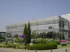
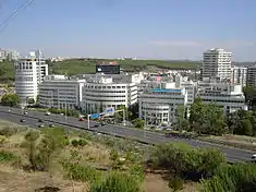
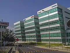
The industrialized and heavily commercial municipality is occupied by several facilities, which include the headquarters of SIC and TVI (two private Portuguese television networks), many large multinational and technology companies, including Nestlé, McDonald's, BP, General Electric, Cisco, Synopsys, P&G, HP, Dell, Epson, Samsung, LG, Unit4, Philips, Intel, General Electric, Colgate-Palmoline, Johnson&Johnson, L'Oréal, Oracle, Atlas Copco, ABB, Daikin Airconditioning, Nike, Nissan, PepsiCo, Pfizer, Grundfos, Merck & Co, Netjets, Synopsys, Miele, Unisys, BMW, Toshiba, Canon, GlaxoSmithKline, Volvo Cars, and FCA (Fiat Chrysler Automobiles). The headquarters of NetJets Europe, Omni Aviation and its Portuguese subsidiary airline White Airways[5][6] are also located in the area. The first Portuguese semiconductor company Chipidea was established in Oeiras until being acquired by MIPS Technologies for $147 million.[7]
The region is also a technology and service incubator with the purposeful creation of many science, technology, research institutions and business parks, including:
- Arquiparque
- Lagoas Park
- Miraflores Premium
- Neo Park
- Parque Holanda
- Parque Suécia
- Quinta da Fonte
- Taguspark - Science and Technology Park
- Tagus Space
Several security and both private and governmental institutions are also within the vicinity: the NATO command post (Joint Command Lisbon); IGC - Instituto Gulbenkian de Ciência, and a pole of the Instituto Nacional dos Recursos Biológicos, responsible for agrarian research, the Estação Agronómica Nacional (National Agronomy Station), are all located within the municipality.
Main sights
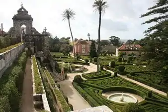
Oeiras offers a range of points of interest, ranging from monuments of unique and historical value, such as the Palace of Marquês de Pombal and Palace of the Royal Estate in Caxias (that dates from the 18th century and surrounded by luxurious gardens) to sites with industrial history, like the Fábrica da Pólvora de Barcarena ('Barcarena Gunpowder Factory'), a reclaimed arms factory used for leisure and cultural purposes.
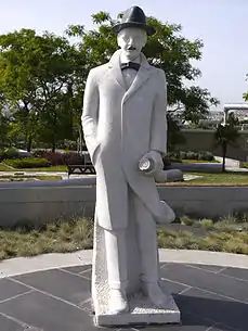
Leisure facilities include the sports complex of Jamor, Oeiras' promenade (linking Algés and Oeiras e São Julião da Barra) and the yacht harbour, in addition to other local parks and green spaces. The modern Parque dos Poetas ('Poets' Park'), a green space with statues of Portuguese poets and writers, is also one of the ex-libris of Oeiras. Many of the former town centres have been recovered, displaying monuments and tourist-oriented venues for leisure, cultural, gastronomic and social events (for example the town of Paço de Arcos).
Monuments
- Marquis of Pombal's Palace
- Lime kilns from the Middle Ages (Fornos da Cal)
Parks
- Oeiras Municipal Park
- Poets' Park
Arts & culture
Festivals
- NOS Alive
- EDP Cool Jazz
Sports
_(165015108).jpg.webp)
The final matches of the Portuguese Men's and Women's Football Cups traditionally take place in the Estádio Nacional in the Jamor complex.
The Portugal Open (previously known as Estoril Open) was an ATP and WTA tennis tournament held in the sports complex of Jamor, from 1990 until 2014.
Education
Education has always been one of the top priorities of Oeiras.
Higher education
- Escola Náutica Infante D. Henrique - in Paço de Arcos
- FMH - Faculdade de Motricidade Humana - in Jamor
- Instituto Superior Técnico (Taguspark) - in Porto Salvo
- University New Atlântica - in Barcarena
Research
- Instituto Gulbenkian de Ciência (IGC)
- Instituto de Tecnologia Química e Biológica (ITQB)
- Instituto de Biologia Experimental e Tecnológica (IBET)
- Instituto de Investigação das Pescas e do Mar (IPIMAR)
- Instituto Nacional de Investigação Agrária e Veterinária (INIAV)
Others
- Instituto Español Giner de los Ríos[8] (Spanish international school) - in Algés, Linda-a-Velha e Cruz Quebrada-Dafundo
- Oeiras International School - in Barcarena
Infrastructure
Transportation
The A5 motorway passes through Oeiras, providing a highway connection to Cascais and Lisbon.
The municipality is served by the Cascais Line, a suburban railway line the runs along the Estoril Coast west from Lisbon. There are six railway stations on the Cascais Line in the municipality, including Oeiras Station that serves the parish centre.
Oeiras formerly contained the SATUOeiras people mover that connected Oeiras Parque Shopping Center with Paço de Arcos. The line operated between 2004 and 2015.[9]
International relations
 Benguela, Angola
 Gebze, Turkey
 Inhambane, Mozambique
 Mindelo, Cape Verde
 Mohammedia, Morocco
 Oeiras, Brazil
 Príncipe, São Tomé and Príncipe
 Quinhámel, Guinea-Bissau
 Saint-Étienne, France
References
- Instituto Nacional de Estatística
- "Áreas das freguesias, concelhos, distritos e país". Archived from the original on 2018-11-05. Retrieved 2018-11-05.
- Diário da República. "Law nr. 11-A/2013, page 552 82" (pdf) (in Portuguese). Retrieved 29 July 2014.
- Oeiras: Factos e Números (in Portuguese), Oeiras, Portugal: Câmara Municipal de Oeiras, July 2003
- "Contacts: White Airways" (in Portuguese). Porto Salvo (Oeiras), Portugal. Retrieved 14 November 2011.
- "Contacts: Omni Aviation" (in Portuguese). Porto Salvo (Oeiras), Portugal. Retrieved 14 December 2011.
- "MIPS Technologies Acquires World's Leading Analog Intellectual Property Company; Acquisition of Chipidea Microelectronica S.A. Propels MIPS to #2 Ranking". Design And Reuse. Retrieved 2016-02-13.
- "ATENCIÓN AL PÚBLICO." Instituto Español Giner de los Ríos. Retrieved on May 2, 2015. "DIRECCIÓN POSTAL Rua Direita do Dafundo, 40 1495-717 Cruz Quebrada-Dafundo Lisboa (Portugal) "
- Soares, Marisa (9 April 2015). "SATU de Oeiras fará a última viagem a 31 de Maio". Publico. Retrieved 7 March 2020.
- "Geminações". cm-oeiras.pt (in Portuguese). Oeiras. Retrieved 2019-12-10.
| Authority control |
|---|
