Antakya
Antakya (Turkish pronunciation: [ɑnˈtɑkjɑ]) is the capital of Hatay Province, the southernmost province of Turkey. The city is located in a well-watered and fertile valley on the Orontes River, about 20 kilometers (12 mi) from the Levantine Sea.
Antakya | |
|---|---|
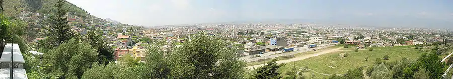
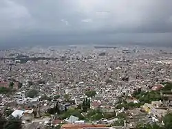 A view of Antakya from high ground | |
 Antakya Location of Antakya within Turkey Antakya Antakya (Europe) | |
| Coordinates: 36°12′N 36°09′E | |
| Country | |
| Region | Mediterranean |
| Province | Hatay Province |
| Area | |
| • District | 858.08 km2 (331.31 sq mi) |
| Elevation | 67 m (220 ft) |
| Population (2012)[2] | |
| • Urban | 216,960 |
| • District | 470,833 |
| • District density | 550/km2 (1,400/sq mi) |
| Time zone | UTC+3 (FET) |
| Postal code | 31xxx |
| Area code(s) | (+90) 326 |
| Licence plate | 31 |
| Website | www |
Today's city stands partly on the site of the ancient Antiochia (Ancient Greek: Ἀντιόχεια, Antiókheia, also known as "Antioch on the Orontes"), which was founded in the 4th century BC by the Seleucid. Antioch later became one of the Roman Empire's largest cities, and was made the capital of the provinces of Syria and Coele-Syria. It was also an influential early center of Christianity, and gained much ecclesiastical importance in the Byzantine Empire. Captured by the Umar ibn al-Khattab in the 7th century, the medieval Antakiyah (Arabic: أنطاكية, ʾAnṭākiya) was conquered or re-conquered several times: by the Byzantine in 969, the Seljuks in 1084,[3] the Crusaders in 1098,[4] the Mamluks in 1268,[5] and eventually the Ottomans in 1517,[4] who would integrate it to the Aleppo Eyalet then to the Aleppo Vilayet. The city joined the Hatay State under the French Mandate before joining the Turkish Republic.
History
Antiquity
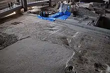
The area of Antioch has been occupied by humans since the Calcolithic era (6th millennium BC), as revealed by archeological excavations of the mound of Tell-Açana, among others.
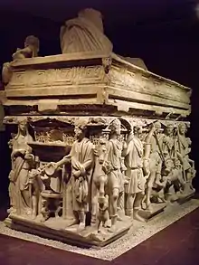
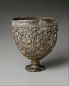
The King of Macedon Alexander the Great, after defeating the Persians in the Battle of Issus in 333 BC, followed the Orontes south into Syria and occupied the area. The city of Antioch was founded in 300 BC, after the death of Alexander, by the Hellenistic Seleucid King Seleucus I Nicator. It played an important role as one of the largest cities in the Hellenistic Seleucid Kingdom, in the Roman Empire, and in the Byzantine Empire. The city swapped hands between the Byzantines and the Persian Sassanids in the 3rd century and was the battleground for the siege of Antioch where Shapur I defeated the Roman army, and a later Battle of Antioch (613) where the Persians were successful at capturing the city for the last time. It was a key city during the early history of Christianity, in particular that of the Syriac Orthodox Church and the Antiochian Orthodox Church, as well as during the rise of Islam and the Crusades.
Rashidun period
In 637, during the reign of the Byzantine emperor Heraclius, Antioch was conquered by the Rashidun Caliphate during the Battle of the Iron Bridge. The city became known in Arabic as أنطاكية (ʾAnṭākiya). Since the Umayyad dynasty was unable to penetrate the Anatolian plateau, Antioch found itself on the frontline of the conflicts between two hostile empires during the next 350 years, so that the city went into a precipitous decline.
In 969, the city was reconquered for the Byzantine Emperor Nikephoros II Phokas by Michael Bourtzes and the stratopedarches Peter. It soon became the seat of a dux, who commanded the forces of the local themes and was the most important officer on the Empire's eastern border, held by such men as Nikephoros Ouranos. In 1078, Philaretos Brachamios, an Armenian rebel, seized power. He held the city until the Seljuk Turks captured it from him in 1084. The Sultanate of Rum held it only fourteen years before the Crusaders arrived.[6]
Crusader era
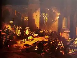
The Crusaders' Siege of Antioch between October 1097 and June 1098 during the First Crusade resulted in its fall. The Crusaders caused significant damage, including a massacre of its population, both Christian and Muslim.[7] Following the defeat of Seljuk forces arriving with the aim to break the siege only four days after its capture by the crusaders, Bohemond I became its overlord.[7] It remained the capital of the Latin Principality of Antioch for nearly two centuries.
In 1268 it fell to the Egyptian Mamluk Sultan Baibars after another siege. Baibars proceeded to massacre the Christian population.[8] In addition to suffering the ravages of war, the city lost its commercial importance because trade routes to East Asia moved north following the 13th-century Mongol conquests. Antioch never recovered as a major city, with much of its former role falling to the port city of Alexandretta (İskenderun). An account of both cities as they were in 1675 appears in the diary of the English naval chaplain Henry Teonge.
Ottoman city
The city was initially the center of the Sanjak of Antakya, part of the Damascus Eyalet. It was laterly center of Sanjak of Antakya in Aleppo Eyalet. It was finally kaza center in Sanjak of Aleppo, part of Aleppo Vilayet.
In 1822 (and again in 1872), Antakya was hit by an earthquake and damaged. When Ottoman general Ibrahim Pasha established his headquarters in the city in 1835, it had only some 5,000 inhabitants. Supporters hoped the city might develop thanks to the Euphrates Valley Railway, which was supposed to link it to the port of Sueida (now Samandağı), but this plan never came to fruition. This scheme is the subject of Letitia Elizabeth Landon's poem ![]() Antioch. (1836) in which she reflects of the superiority of trade and commerce over war and conflict. The city suffered repeated outbreaks of cholera due to inadequate infrastructure for sanitation.[6] Later the city developed and rapidly resumed much of its old importance when a railway was built along the lower Orontes Valley.
Antioch. (1836) in which she reflects of the superiority of trade and commerce over war and conflict. The city suffered repeated outbreaks of cholera due to inadequate infrastructure for sanitation.[6] Later the city developed and rapidly resumed much of its old importance when a railway was built along the lower Orontes Valley.
French Mandate and Turkish annexation
Antioch was part of the Sanjak of Alexandretta during the French Mandate of Syria and Lebanon, until it was made the Hatay State in 1938, after Turkish pressure.[9] An Arab nationalist newspaper in the city, run by Zaki al-Arsuzi, was shut down by the Turks. The annexation of the Hatay State by Turkey in 1939, creating the Hatay Province, caused an exodus of Christians and Alawites from Antioch east to the French Mandate.
Demographics in 1935
In 1935, Turkish and Arab Muslims made more than 80% of population.
| Ethnic group | Population (percentage) |
|---|---|
| Sunni Muslims | 19,720 (58%)[11] |
| Alawites | 8,670 (25.5%)[11] |
| Christians | 4,930 (14.5%)[11] |
| Others | 680 (2%) |
| Total¹ | 34,000 (100%)[11] |
¹Most Alawis and Armenians spoke Turkish as a second language[10] and spoke either Arabic or Armenian as a first language.
A British traveller at Antakya in year 1798 said "the language here is generally Turkish" (while, by contrast the prevalent language at Aleppo at the time was Arabic).[12]
City of Antakya today
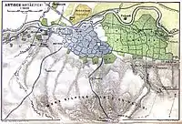
Mount Habib-i Neccar (Habib An-Najar in Sura al Yassin 36:13 ) and the city walls which climb the hillsides symbolise Antakya, making the city a formidable fortress built on a series of hills running north-east to south-west. Antakya was originally centred on the east bank of the river. Since the 19th century, the city has expanded with new neighbourhoods built on the plains across the river to the south-west, and four bridges connect the old and new cities. Many of the buildings of the last two decades are styled as concrete blocks, and Antakya has lost much of its classic beauty. The narrow streets of the old city can become clogged with traffic.
Although the port city Iskenderun has become the largest city in Hatay, Antakya is a provincial capital still of considerable importance as the centre of a large district. The draining of Lake Amik and development of land has caused the region's economy to grow in wealth and productivity. The town is a lively shopping and business centre with many restaurants, cinemas and other amenities. This district is centred on a large park opposite the governor's building and the central avenue Kurtuluş Caddesı. The tea gardens, cafes and restaurants in the neighbourhood of Harbiye are popular destinations, particularly for the variety of meze in the restaurants. The Orontes River can be malodorous when water is low in summer. Rather than formal nightlife, in the summer heat, people will stay outside until late in the night to walk with their families and friends, and munch on snacks.
Its location near the Syrian border makes Antakya more cosmopolitan than many cities in Turkey. It did not attract the mass immigration of people from eastern Anatolia in the 1980s and 1990s that radically swelled the populations of Mediterranean cities such as Adana and Mersin. Both Turkish and Arabic are still widely spoken in Antakya, although written Arabic is rarely used. A mixed community of faiths and denominations co-exist peacefully here. Although almost all the inhabitants are Muslim, a substantial proportion adhere to the Alevi and the Arab Alawi traditions, in 'Harbiye' there is a place to honour the saint Hızır. Numerous tombs of saints, of both Sunni and Alawite, are located throughout the city. Several small Christian communities are active in the city, with the largest church being St. Peter and St. Paul on Hurriyet Caddesi. With its long history of spiritual and religious movements, Antakya is a place of pilgrimage for Christians. The Jewish community of Antakya had shrunk to 14 members in 2014.[13][14] It has a reputation in Turkey as a place for spells, fortune telling, miracles and spirits.
Local crafts include a soap scented with the oil of bay tree.
Geography
Antakya is located on the banks of the Orontes River (Turkish: Asi Nehri), approximately 22 km (14 mi) inland from the Mediterranean coast. The city is in a valley surrounded by mountains, the Nur Mountains (ancient Amanos) to the north and Mount Keldağ (Jebel Akra) to the south, with the 440 m high Mount Habib-i Neccar (the ancient Mount Silpius) forming its eastern limits. The mountains are a source of a green marble. Antakya is at the northern edge of the Dead Sea Rift and vulnerable to earthquakes.
The plain of Amik to the north-east of the city is fertile soil watered by the Orontes, the Karasu and the Afrin rivers; the lake in the plain was drained in 1980 by a French company. At the same time channels were built to widen the Orontes and let it pass neatly through the city centre. The Orontes is joined in Antakya by the Hacı Kürüş stream to the north-east of the city near the church of St Peter, and the Hamşen which runs down from Habib-i Neccar to the south-west, under Memekli Bridge near the army barracks. Flora includes the bay trees and myrtle.
Climate
The city enjoys a hot-summer Mediterranean climate (Köppen climate classification Csa) with hot and dry summers, and mild and wet winters; however due to its higher altitude, Antakya has slightly cooler temperatures than the coast.
| Climate data for Antakya | |||||||||||||
|---|---|---|---|---|---|---|---|---|---|---|---|---|---|
| Month | Jan | Feb | Mar | Apr | May | Jun | Jul | Aug | Sep | Oct | Nov | Dec | Year |
| Average high °C (°F) | 11 (51) |
14 (57) |
18 (64) |
22 (71) |
26 (78) |
28 (82) |
30 (86) |
31 (87) |
30 (86) |
27 (80) |
20 (68) |
13 (55) |
22 (71) |
| Average low °C (°F) | 4 (39) |
5 (41) |
8 (46) |
11 (51) |
15 (59) |
20 (68) |
23 (73) |
24 (75) |
20 (68) |
14 (57) |
8 (46) |
5 (41) |
13 (55) |
| Average precipitation mm (inches) | 190 (7.5) |
170 (6.5) |
140 (5.6) |
110 (4.2) |
81 (3.2) |
33 (1.3) |
7.6 (0.3) |
5.1 (0.2) |
28 (1.1) |
89 (3.5) |
110 (4.3) |
190 (7.5) |
1,150 (45.1) |
| Source: Weatherbase[15] | |||||||||||||
Education
Mustafa Kemal University, abbreviated as MKU, has several faculties including Engineering and Medicine, while having a campus called Tayfur Sökmen located in Serinyol district 15 km (9.3 mi), north of Antakya (centrum). Established in 1992, currently more than 32,000 students enrolled at the university.[16]
Besides the campus in Serinyol, MKU has its faculties spread out in all main districts of the province including Altınözü, Antakya, Belen, Dörtyol, Erzin, Hassa, İskenderun, Kırıkhan, Reyhanlı, Samandağ and Yayladağı.
Main sights
.jpg.webp)
The long and varied history has created many architectural sites of interest. There is much for visitors to see in Antakya, although many buildings have been lost in the rapid growth and redevelopment of the city in recent decades.
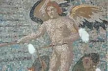
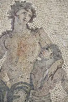
- Hatay Archaeology Museum has the second largest collection of Roman mosaics in the world.
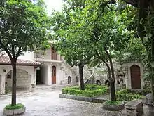
- The rock-carved Church of St Peter, with its network of refuges and tunnels carved out of the rock, a site of Christian pilgrimage. There are also tombs cut into the rock face at various places along the Orontes valley.
- Old market district: It offers plenty of traditional shops, where you can explore what you have not seen before. It is exactly in the city centre, you are in when you see the sign Uzun Çarşı Caddesi.
- The seedy Gündüz cinema in the city centre was once used as parliament building of the Republic of Hatay.
- The waterfalls at the Harbiye / Daphne promenade.
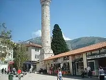
- The Ottoman Habib'i Neccar Mosque, the oldest mosque in Antakya and one of the oldest in Anatolia.
- The labyrinth of narrow streets and old Antakya houses. This district is the oldtown in fact.
- Vespasianus Titus Tunnel-Samandagı. It is approximately 35 km. far from the centre.
- Beşikli Cave and Graves (the antique city of Seleukeia Pierria)
- St. Simon Monastery
- Bagras (Bakras) Castle, which was built in antiquity and restored many times in later centuries (particularly during the Crusades, when it was a stronghold of the Knights Templar), served as a watchtower on the 27 km (17 mi) mountain road from İskenderun (Alexandretta) to Antakya (Antioch).
- The panoramic view of the city from the heights of Mount Habib-i Neccar
- St. Paul Orthodox Church
With its rich architectural heritage, Antakya is a member of the Norwich-based European Association of Historic Towns and Regions . The Roman bridge (thought to date from the era of Diocletian) was destroyed in 1972 during the widening and channelling of the Orontes.
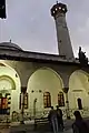 Antakya Yeni Camii Exterior
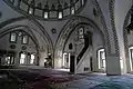 Antakya Habib-i Neccar Camii Interior
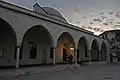 Antakya Habib-i Neccar Camii Exterior
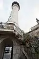 Antakya Sarimiye Mosque Minaret
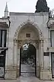 Antakya Ulu Cami Entrance to courtyard
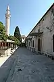 Antakya Ulu Cami
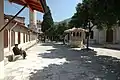 Antakya Ulu Cami
.jpg.webp) View of the river in the 1780s, by Louis-François Cassas.
View of the river in the 1780s, by Louis-François Cassas.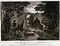 Medina gate in the 1780s, by Louis-François Cassas.
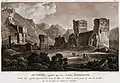 Ruins of the Seleucus palace in the 1780s, by Louis-François Cassas.
Transport
The city is served from Hatay Airport.
Sports
Antakya has one male professional football club, Hatayspor, who play in the TFF 1. Lig. There is also a female professional team called Hatay Büyükşehir Belediyesi. Hatay Büyükşehir Belediyespor, a woman's basketball team, is also present, and plays in the Turkish Women's Basketball League.
Cuisine
The cuisine of Antakya is renowned. Its cuisine is considered levantine rather than Turkish. The cuisine offers plenty of meals, where beef and lambs are mainly used. Popular dishes include the typical Turkish kebab, served with spices and onions in flat unleavened bread, with yoghurt as ali nazik kebab, oruk, kaytaz böreği and katıklı ekmek . Hot spicy food is a feature of this part of Turkey, along with Turkish coffee and local specialities. Here are some savour:
- İçli köfte and other oruk varieties: varieties of the Arabic kibbeh, deep-fried balls of bulgur wheat stuffed with minced meat; or baked in ovens in cylinder-cone shape. Saç oruğu is made of the same ingredients, however in circular shape.
- Kaytaz böreği: It is patty that is made of wheat, beef, tomato and onion.
- Katıklı ekmek: Ingredients in Katıklı Ekmek usually consist of wheat, traditional pepper (paste), spices such as sesame and theme, çökelek or cheese. It looks like an ancestor of pizza. Not a lot of restaurants serve it, however it can be found in old-market that is located in the centre and Harbiye.
- Pomegranate syrup, used as a salad dressing, called debes ramman, a traditional Levantine Arabic dressing.
- Semirsek, a thin bread with hot pepper, minced meat or spinach filling
- Spicy chicken, a specialty of Harbiye
- Za'atar (Zahter) a traditional Levantine Arabic paste of spiced thyme, oregano, and sesame seeds, mixed with olive oil, spread on flat (called pide or in English pita) bread.
- Fresh chick peas, munched as a snack.
- Hirise, boiled and pounded wheat meal.
- Aşur, meat mixed with crushed wheat, chickpea, cumin, onion, pepper and walnut
- Hummus - the chick-pea dip
- pureed fava beans
- Patlıcan salatası: Patlıcan salatası or babaganoush, made of baked and sliced aubergines that mixed
with pepper and tomato. It is usually served with pomegranate syrup.
- Taratur: Known also as Tarator, made of walnuts, 'tahin', yogurt and garlic.
- Süzme yoğurt: A type of yogurt that its water content is removed with traditional methods.
- Ezme biber: It is made of pepper and walnuts.
- Surke - dried curds served in spicy olive oil
- Çökelek - the spicy sun-dried cheese
- Eels from the Orontes, spiced and fried in olive oil
- Sweets/desserts
- Künefe - a hot cheese, kadaif-based sweet. Antakya is Turkey's künefe capital; the pastry shops in the centre compete to claim being kings Turkish: kral of the pastry.
- Müşebbek - rings of deep fried pastry.
- Peynirli irmik helvası - Peynirli İrmik Helvası is a dessert that is made of semolina, sugar and traditional cheese that is the same as used in künefe. It is served warm, especially in restaurants in the region Harbiye, rather than künefe shops that are located in the centre.
Notable people
- Alexandros (1st century BC) Greek sculptor
- George of Antioch
- Ignatius of Antioch, Patriarch of Antioch
- John Chrysostom (349–407) Patriarch of Constantinople
- Saint Luke, 1st century AD, Christian evangelist and author of the Gospel of St. Luke and Acts of the Apostles
- Yağısıyan, Seljukid governor of the city up to its capture by the Crusaders
- Selâhattin Ülkümen - Righteous among the nations
- Tayfur Sökmen - The president of the Republic of Hatay during its existence between the years 1938 and 1939.
References
- "Area of regions (including lakes), km²". Regional Statistics Database. Turkish Statistical Institute. 2002. Retrieved 2013-03-05.
- "Population of province/district centers and towns/villages by districts - 2012". Address Based Population Registration System (ABPRS) Database. Turkish Statistical Institute. Retrieved 2013-02-27.
- .
- .
- .
- Rockwell 1911, p. 131.
- Burns, Ross (2013). Aleppo, A History. Routledge. pp. 109–111. ISBN 9780415737210.
- Vahan M. Kurkjian, "New Scourge from Egypt", in A History of Armenia
- Sarah D. Shields, Fezzes in the River: Identity Politics and European Diplomacy in the Middle East on the Eve of World War II, 2011
- Dumper, Michael (2007). Cities of the Middle East and North Africa: A Historical Encyclopedia. ABC-CLIO. p. 40. ISBN 9781576079195.
- Go, Julian (2013). Decentering Social Theory. Emerald Group Publishing. p. 31. ISBN 9781781907276.
- Travels in Africa, Egypt, and Syria, from the Year 1792 to 1798, by William George Browne, year 1806 on page 449 (and page 442 for Aleppo).
- Chudacoff, Danya (May 14, 2014). "Turkey's Jewish community longs for the past". Aljazeera. Retrieved February 18, 2018.
- Avotaynu: the international review of Jewish genealogy, Volume 14, G. Mokotoff, 1998, p. 40.
- "Weatherbase: Weather for Antakya, Turkey". Weatherbase. 2011. Retrieved on November 22, 2011.
- "About Mustafa Kemal University (MKU)". MKU. Retrieved 2011-03-26.
- Glanville Downey (1963). Ancient Antioch. Princeton University Press.
- Rockwell, William Walker (1911). . In Chisholm, Hugh (ed.). Encyclopædia Britannica. 2 (11th ed.). Cambridge University Press. pp. 130–132.CS1 maint: ref=harv (link)
External links
| Wikivoyage has a travel guide for Antakya. |
Antakya in Hatay Province of Turkey | |||||||||||||||||||||||||||
|---|---|---|---|---|---|---|---|---|---|---|---|---|---|---|---|---|---|---|---|---|---|---|---|---|---|---|---|
| Districts | 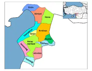 Districts of Hatay | ||||||||||||||||||||||||||
| |||||||||||||||||||||||||||
Metropolitan municipalities are bolded. | |||||||||||||||||||||||||||
| Authority control |
|---|