Paniai Regency
Paniai Regency is one of the regencies (kabupaten) in Papua Province of Indonesia. It is named after the Paniai Lakes. It covers an area of 6,525.25 km2, and had a population of 153,432 at the 2010 Census;[1] the latest official estimate (as at January 2014) is 188,796. The administrative centre is Enarotali, in East Paniai.
Paniai Regency
Kabupaten Paniai | |
|---|---|
 Coat of arms | |
| Motto(s): Awetako Enaa Agapida | |
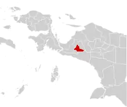 | |
 Paniai Regency Location in Western New Guinea and Indonesia  Paniai Regency Paniai Regency (Indonesia) | |
| Coordinates: 3.9000°S 136.6000°E | |
| Country | |
| Province | |
| Capital | Enarotali |
| Government | |
| • Regent | Hengki Kayame |
| • Vice Regent | Yohanis You |
| Area | |
| • Total | 6,525.25 km2 (2,519.41 sq mi) |
| Population (2014) | |
| • Total | 188,796 |
| • Density | 29/km2 (75/sq mi) |
| Time zone | UTC+9 (Indonesia Eastern Time) |
| Area code | (+62) 971 |
| Website | paniai |
Administrative districts
At the 2010 Census, Paniai Regency comprised ten districts (kecamatan), tabulated below with their populations at the 2010 census.[2] However, by 2018 the splitting of existing districts to create additional ones had raised the total to twenty-three districts.
| District | Population 2010 census |
|---|---|
| Paniai Timur (East Paniai) | 32,864 |
| Tatamo | 14,435 |
| Kebo | 19,017 |
| Bibida | 1,781 |
| Dumadama | 4,860 |
| Aradide | 13,045 |
| Ekadide | 20,734 |
| Paniai Barat (West Paniai) | 28,877 |
| Siriwo | 6,364 |
| Bogobaida | 11,455 |
The fourteen new districts created since 2013 are: Aweida, Baya Biru, Delyai Miyo, Dogomo, Muye, Nakama, Pugo Dagi, Teluk Deya (Deya Bay), Topiyai, Wegee Bino, Wegee Muka, Yagai, Yatamo and Youtadi, while Tatamo has ceased to exist.
References
- Biro Pusat Statistik, Jakarta, 2011.
- Biro Pusak Statistik, Jakarta, 2011.