Mappi Regency
Mappi Regency is one of the regencies (kabupaten) in the southern portion of Papua Province of Indonesia. It was split off from Merauke Regency (of which it had been a component part) on 12 November 2002. It covers an area of 28,518.00 km2, and had a population of 81,658 at the 2010 Census[2] and 91,876 at the 2015 Census; the latest official estimate (as at mid 2019) is 102,113. The administrative centre is the town of Kepi.
Mappi Regency
Kabupaten Mappi | |
|---|---|
 Coat of arms | |
| Motto(s): Usubi Yohokuda - Tako Bayaman (Peace in One Heart - Serving Each Other) | |
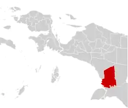 | |
 Mappi Regency Location in Western New Guinea and Indonesia  Mappi Regency Mappi Regency (Indonesia) | |
| Coordinates: 6.4997°S 139.3444°E | |
| Country | |
| Province | |
| Capital | Kepi |
| Government | |
| • Regent | Kristosimus Agawemu |
| • Vice Regent | Ibnu Jaya Suud |
| Area | |
| • Total | 28,518 km2 (11,011 sq mi) |
| Population (2019)[1] | |
| • Total | 102,113 |
| • Density | 3.6/km2 (9.3/sq mi) |
| Time zone | UTC+9 (Indonesia Eastern Time) |
| Area code | (+62) 411 |
| Website | mappikab.go.id |
Administrative districts
Mappi Regency in 2010 comprised ten districts (distrik). However, by 2015 the number of districts had been increased to fifteen; the five additional districts that have been created since 2010 are Bamgi, Passue Bawah, Syahcame, Ti Zain and Yakomi.
The districts are listed below with their areas and their populations at the 2010 Census[3] and that of 2015.[4] The table also includes the number of administrative villages (desa and kelurahan) in each district, and its post code.
| District | Area in km2 | Population 2010 Census | Population 2010 Census | No. of villages | Post code |
|---|---|---|---|---|---|
| Obaa | 2,307 | 19,454 | 21,827 | 24 | 99870 |
| Mambioman Bapai | 4,704 | 7,904 | 8,908 | 15 | 99873 |
| Edera | 1,654 | 12,191 | 8,010 | 7 | 99852 |
| Syahcame | 1,055 | (a) | 3,209 | 6 | 99853 |
| Bamgi | 750 | (a) | 2,479 | 5 | 99851 |
| Venaha | 2,951 | 3,849 | 2,427 | 8 | 99854 |
| Yakomi | 787 | (a) | 1,891 | 7 | 99855 |
| Minyamur | 2,054 | 4,310 | 4,854 | 12 | 99872 |
| Passue | 2,075 | 5,100 | 5,761 | 13 | 99871 |
| Haju | 1,432 | 8,774 | 9,852 | 19 | 99881 |
| Assue | 3,265 | 8,887 | 10,009 | 18 | 99874 |
| Citak Mitak | 1,456 | 7,211 | 5,565 | 7 | 99875 |
| Kaibar | 1,570 | 3,978 | 1,903 | 7 | 99876 |
| Passue Bawah | 1,229 | (a) | 2,579 | 8 | 99877 |
| Ti Zain | 1,229 | (a) | 2,602 | 8 | 99878 |
| Totals | 28,518.00 | 81,658 | 91,876 | 164 |
Note: (a) the 2010 populations of these areas were included in the figures for the original districts from which they were cut out.
References
- Badan Pusat Statistik, Jakarta, 2020.
- Biro Pusat Statistik, Jakarta, 2011.
- Biro Pusat Statistik, Jakarta, 2011.
- Badan Pusat Statistik, Jakarta, 2017.