Puncak Jaya Regency
Puncak Jaya Regency is one of the regencies (kabupaten) in Papua Province, Indonesia. It is an inland highland regency,[1] lying directly east of Paniai Regency and west of Jayawijaya Regency and Tolikara Regency (including those new regencies which have subsequently been created within the former boundaries of those regencies).[2] As of 2004, it was reported that these four regencies had a population that is 93–97% ethnic Papua;[1] however this included areas which have subsequently been formed into new regencies.
Puncak Jaya Regency
Kabupaten Puncak Jaya | |
|---|---|
 A view of the peak of Puncak Jaya, located in the southwestern portion of the regency | |
 Coat of arms | |
| Motto(s): Yabu Eeruwok | |
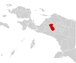 | |
 Puncak Jaya Regency Location in Western New Guinea and Indonesia  Puncak Jaya Regency Puncak Jaya Regency (Indonesia) | |
| Coordinates: 4.0789°S 137.1583°E | |
| Country | |
| Province | Papua |
| Capital | Mulia |
| Government | |
| • Regent | Yuni Wonda |
| • Vice Regent | Deinas Geley |
| Area | |
| • Total | 4,989.51 km2 (1,926.46 sq mi) |
| Population (2014) | |
| • Total | 124,461 |
| • Density | 25/km2 (65/sq mi) |
| Time zone | UTC+9 (Indonesia Eastern Time) |
| Area code | (+62) 901 |
| Website | puncakjayakab |
An additional regency - simply named Puncak Regency - has been created within the area of Puncak Jaya Regency. The residual Puncak Jaya Regency covers an area of 4,989.51 km2, and had a population of 101,148 at the 2010 Census;[3] the latest official estimate (as at January 2014) is 124,461.
The capital of the regency is Mulia.[4][5][6]
According to a 2009 profile in Indonesia's Tempo magazine, Puncak Jaya had sixteen districts (kecamatan) and 147 villages, and 147,000 residents;[7] however this did not take account of the fact that under the Law No. 7/2008, eight of these districts had already been removed from Puncak Jaya Regency and formed into a separate Puncak Regency in 2008. The 2010 Census revealed a population of 101,148 in the residual Puncak Jaya Regency, and the latest estimate (2014) is 124,461. It is a difficult ten-hour drive from Wamena (Jayawijaya Regency) to the mostly undeveloped regency. Separatists in the Free Papua Movement are active in the area.[7]
Puncak Jaya, a mountain peak, is the highest mountain in Indonesia - and in fact the highest anywhere between the Andes and the Himalayas.
Administrative Districts
At the 2010 Census, the existing regency comprised eight districts (kecamatan), tabulated below with their populations at the 2010 Census.[8] Howeber, by 2018 these had been split to create additional districts, which in 2018 numbered twenty-six.
| District | Population 2010 Census |
|---|---|
| Fawi | 3,420 |
| Mulia | 22,278 |
| Mewoluk | 5,189 |
| Yamo | 13,161 |
| Ilu | 18,344 |
| Torere | 6,710 |
| Jigonikme | 8,040 |
| Tingginambut | 24,006 |
The nineteen new districts created by 2018 are Dagai, Dokome, Gubume, Gurage, Ilamburawi, Irimuli, Kalome, Kiyage, Lumo, Molanikime, Muara, Nioga, Nume, Pagaleme, Taganombak, Waegi, Wanwi, Yambi and Ysmoneri; the previous Jigonikme District has ceased to exist.
Towns included
- Aginilia
- Buguba
- Jebegot
- Lambo
- Mulia
- Mbambawa
- Motorbivak
- Rustoord
- Splitsingbivak
- Tombage
Climate
Mulia, the seat of the regency has a subtropical highland climate (Cfb) with heavy rainfall year-round.
| Climate data for Mulia | |||||||||||||
|---|---|---|---|---|---|---|---|---|---|---|---|---|---|
| Month | Jan | Feb | Mar | Apr | May | Jun | Jul | Aug | Sep | Oct | Nov | Dec | Year |
| Average high °C (°F) | 24.3 (75.7) |
24.2 (75.6) |
23.9 (75.0) |
23.7 (74.7) |
23.3 (73.9) |
22.4 (72.3) |
21.7 (71.1) |
21.7 (71.1) |
22.6 (72.7) |
23.7 (74.7) |
24.1 (75.4) |
24.1 (75.4) |
23.3 (74.0) |
| Daily mean °C (°F) | 18.7 (65.7) |
18.7 (65.7) |
18.6 (65.5) |
18.5 (65.3) |
18.3 (64.9) |
17.7 (63.9) |
17.1 (62.8) |
17.1 (62.8) |
17.5 (63.5) |
18.2 (64.8) |
18.4 (65.1) |
18.6 (65.5) |
18.1 (64.6) |
| Average low °C (°F) | 13.1 (55.6) |
13.2 (55.8) |
13.4 (56.1) |
13.4 (56.1) |
13.3 (55.9) |
13.1 (55.6) |
12.6 (54.7) |
12.5 (54.5) |
12.4 (54.3) |
12.7 (54.9) |
12.7 (54.9) |
13.2 (55.8) |
13.0 (55.4) |
| Average rainfall mm (inches) | 260 (10.2) |
288 (11.3) |
293 (11.5) |
262 (10.3) |
230 (9.1) |
215 (8.5) |
219 (8.6) |
222 (8.7) |
220 (8.7) |
238 (9.4) |
215 (8.5) |
228 (9.0) |
2,890 (113.8) |
| Source: Climate-Data.org[9] | |||||||||||||
External links
- Detail maps from Indonesian government, this regency:[10] (includes northern portion) [11] (includes southern portion, including location of Mulia)
References
- McGibbon, Rodd. Plural Society in Peril: Migration, Economic Change, and the Papua Conflict, East–West Center (2004). Retrieved December 20, 2010.
- Map of Papua Province, Indonesia, East–West Center publication. Retrieved December 20, 2010.
- Biro Pusat Statistik, Jakarta, 2011.
- http://www.pvtr.org/pdf/weekly%20reports/Indonesia/December10/Indonesia-06-12December10.pdf
- "TWIN OTTER SKIDS AT MULIA AIRPORT, PAPUA. – ANT – LKBN ANTARA (Indonesia) | HighBeam Research". Highbeam.com. 2006-02-14. Retrieved 2010-12-21.
- Country Reports on Human Rights ... – Google Books. Retrieved 2010-12-21.
- (16 March 2009). Building a New Papua,Tempo. Retrieved December 20, 2010.
- Biro Pusat Statistik, Jakarta, 2011".
- "Climate: Mulia". Climate-Data.org. Retrieved 26 November 2020.
- http://geospasial.bnpb.go.id/wp-content/uploads/2010/09/indeks_peta/250K/ID-J24-250K.pdf
- http://geospasial.bnpb.go.id/wp-content/uploads/2010/09/indeks_peta/250K/ID-K24-250K.pdf