Yapen Islands Regency
Yapen Islands Regency is a regency (kabupaten) in Papua Province of northeastern Indonesia. It covers an area of 2,406.73 km2 (929.24 sq mi), and had a population of 82,951 at the 2010 Census;[2] the latest official estimate (as at mid 2019) is 101,204. It lies in Cenderawasih Bay of Western New Guinea.
Yapen Islands Regency
Kabupaten Kepulauan Yapen | |
|---|---|
 Coat of arms | |
| Motto(s): Acis | |
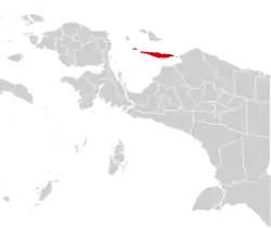 | |
 Yapen Islands Regency Location in Western New Guinea and Indonesia  Yapen Islands Regency Yapen Islands Regency (Indonesia) | |
| Coordinates: 1.7877°S 136.2772°E | |
| Country | |
| Province | |
| Capital | Serui |
| Government | |
| • Regent | Toni Tesar |
| • Vice Regent | Frans Sanadi |
| Area | |
| • Total | 2,406.73 km2 (929.24 sq mi) |
| Population (2019)[1] | |
| • Total | 101,204 |
| • Density | 42/km2 (110/sq mi) |
| Time zone | UTC+9 (Indonesia Eastern Time) |
| Area code | (+62) 983 |
| Website | kepyapenkab |
Geography
The regency includes the islands and island groups of the Yapen Islands archipelago, including Yapen island. Its capital is Serui, on Serui Island (part of Yapen Selatan district).
Administrative Districts
The Yapen Islands regency in 2010 comprised twelve districts (kecamatan), tabulated below with their populations at the 2010 Census;[3] however, by 2018 four additional districts has been created (Anotaurei, Pulau Kurudu, Pulau Yerui and Yawakukat), bringing the total to sixteen, which are subdivided into 165 administrative "villages". Kurudu Island (Pulau Kurudu) lies to the east of Yapen, and Num Island (Pulau Yerui) lies to the west of Yapen, while the Ambai Islands (Kepulauan Ambai) lie immediately off the south coast of Yapen. The table also includes the name of the administratice centre of each district, the number of administrative villages in each district (160 rural desa and 5 urban kelurahan in total) and its post code.
| District | Area in km2 | Pop'n 2010 Census | Pop'n mid 2019 Estimate | Admin centre | No. of vill. | Post code |
|---|---|---|---|---|---|---|
| Yapen Selatan (South Yapen) | 58.28 | 38,032 | 41,185 | Serui | 13 | 98612 -98627 |
| Yapen Barat (West Yapen) | 243.16 | 7,831 | 8,530 | Ansus | 17 | 98648 |
| Yapen Timur (East Yapen) | 168.96 | 4,618 | 4,975 | Dawai | 11 | 98644 |
| Angkaisera | 159.06 | 8,046 | 8,731 | Menawi | 11 | 98655 |
| Poom | 123.19 | 3,128 | 3,396 | Poom | 8 | 98652 |
| Kosiwo | 362.79 | 3,781 | 4,116 | Tatui | 15 | 98632 |
| Yapen Utara (North Yapen) | 386.41 | 2,304 | 2,517 | Tindaret | 7 | 98645 |
| Raimbawi | 179.93 | 2,455 | 1,199 | Waindu | 7 | 98641 |
| Teluk Ampimoi (Ampimoi Bay) | 266.04 | 3,416 | 3,705 | Randawaya | 11 | 98642 |
| Kepulauan Ambai (Ambai Islands) | 27.39 | 3,656 | 3,976 | Ambai | 18 | 98653 |
| Wonawa | 123.72 | 3,153 | 3,079 | Wooi | 10 | 98647 |
| Windesi | 222.04 | 2,530 | 2,763 | Windesi | 9 | 98651 |
| Pulau Kurudu (Kurudu Island) | 21.49 | (a) | 1,464 | Kirimbri | 8 | 98643 |
| Pulau Yerui (Yerui or Num Island) | 90.06 | (b) | 358 | Miosnum | 5 | 98646 |
| Anotaurei | (c) | (c) | (c) | Antorei | 8 | 98631 |
| Yawakukat | (d) | (d) | (d) | Woniwon | 7 | 98654 |
| Totals | 2,432.49 | 82,951 | 89,994 | 165 |
Notes:
(a) the 2010 figure for Pulau Kurudu District is included in that for Yapen Timur District, from which it was split.
(b) the 2010 figure for Pulau Yerui District is included in that for Yapen Barat District, from which it was split.
(c) the figures for Aotaurei District are included in those for Yapen Selatan, from which it was split.
(d) the figures for Yawakukat District are included in those for the district from which it was split.
Climate
Serui has a tropical rainforest climate (Af) with heavy rainfall year-round.
| Climate data for Serui | |||||||||||||
|---|---|---|---|---|---|---|---|---|---|---|---|---|---|
| Month | Jan | Feb | Mar | Apr | May | Jun | Jul | Aug | Sep | Oct | Nov | Dec | Year |
| Average high °C (°F) | 30.4 (86.7) |
30.3 (86.5) |
30.3 (86.5) |
30.5 (86.9) |
30.4 (86.7) |
29.8 (85.6) |
29.2 (84.6) |
29.4 (84.9) |
29.9 (85.8) |
30.3 (86.5) |
30.5 (86.9) |
30.5 (86.9) |
30.1 (86.2) |
| Daily mean °C (°F) | 26.4 (79.5) |
26.4 (79.5) |
26.4 (79.5) |
26.6 (79.9) |
26.6 (79.9) |
26.1 (79.0) |
25.6 (78.1) |
25.7 (78.3) |
26.0 (78.8) |
26.3 (79.3) |
26.5 (79.7) |
26.5 (79.7) |
26.3 (79.3) |
| Average low °C (°F) | 22.5 (72.5) |
22.5 (72.5) |
22.6 (72.7) |
22.7 (72.9) |
22.8 (73.0) |
22.5 (72.5) |
22.1 (71.8) |
22.1 (71.8) |
22.2 (72.0) |
22.4 (72.3) |
22.6 (72.7) |
22.6 (72.7) |
22.5 (72.5) |
| Average rainfall mm (inches) | 267 (10.5) |
277 (10.9) |
317 (12.5) |
217 (8.5) |
251 (9.9) |
248 (9.8) |
246 (9.7) |
279 (11.0) |
234 (9.2) |
236 (9.3) |
224 (8.8) |
286 (11.3) |
3,082 (121.4) |
| Source: Climate-Data.org[4] | |||||||||||||
See also
- Yapen Islands topics
References
- Badan Pusat Statistik, Jakarta, 2020.
- Biro Pusat Statistik, Jakarta, 2011.
- Biro Pusat Statistik, Jakarta, 2011.
- "Climate: Serui". Climate-Data.org. Retrieved 26 November 2020.
| Wikimedia Commons has media related to Yapen Islands Regency. |