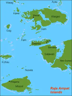
Pitt Strait (Indonesia)
Pitt Strait (Indonesia) (a.k.a. Pitt's Strait, Sagewin Strait),[1] falls within the waters of the Indonesian province of West Papua. The strait separates the Raja Ampat islands of Batanta and Salawati and links the Ceram Sea to the Pacific Ocean.[2][3] To its west lies Dampier Strait, which separates Batanta island from Waigeo island.[3][4] The Sagewin Strait name refers to Sagewin Island, which lies at the south east side of Pitt Strait, close to Salawati.
| Pitt Strait | |
|---|---|
 | |
 Pitt Strait | |
| Coordinates | 00°55′00″S 130°45′00″E |
| Type | strait |
| Native name | Indonesian: Selat Sagewin |
| Basin countries | Indonesia |
| References | Straat Sagewin: Indonesia National Geospatial-Intelligence Agency, Bethesda, MD, USA |
History
In 1759 Captain William Wilson sailing in the East Indiaman Pitt navigated these waters and named the channel between Batanta and Salawati Pitt Strait, after his vessel, or equally, her namesake.[3] He also named the two islands King George's Island and Prince of Wales's Island,[5] but these names did not prove as durable as that of the strait.
The area of the Dampier Strait and Pitt Strait are a Marine Protected Area for cetaceans.[6]
Citations and references
Citations
- Andaya (1993), p. 229.
- United States Hydrographic Office (1916), p. 272.
- Moore (2003), p. 87.
- United States Hydrographic Office (1916), pp. 266–268.
- Naval Chronicle (Jul-Dec 1805), Vol. 14, p.140.
- Hoyt (2013), p. 309.
References
- Andaya, Leonard Y. (1993). The world of Maluku: eastern Indonesia in the early modern period. University of Hawaii Press. ISBN 978-0824814908.
- Crowhurst, R.P. (1969). "The voyage of the Pitt – a turning point in the East India navigation". Mariner's Mirror. 55: 43–56.
- Hoyt, Erich (2013). Marine Protected Areas for Whales, Dolphins and Porpoises: A World Handbook for Cetacean Habitat Conservation and Planning. Routledge. ISBN 978-1844077625.
- Moore, Clive (2003). New Guinea: Crossing Boundaries and History. University of Hawaii Press. ISBN 978-0824824853.
- United States Hydrographic Office under the authority of the secretary of the navy (1916). East Indies Pilot: Southern part.
Indonesian seas | |
|---|---|
| Ocean | |
| Sea | |
| Strait |
|
| Gulf | |