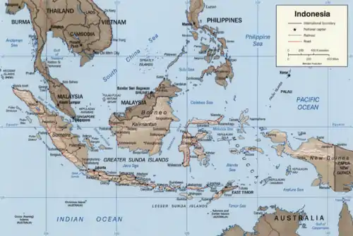
East Indian Archipelago
The East Indian Archipelago (Indonesia) is an area designated by the International Hydrographic Organization (IHO). It encompasses twelve seas, two gulfs, and one strait in the East Indies (Southeast Asia).[1]
Seas
In draft 4 of the IHO's publication S-23 Limits of Oceans and Seas, 2002, the area is described in a chapter under the heading South China & Eastern Archipelagic Seas.
The waters of the East Indian Archipelago are:
- Banda Sea - 695,000 km²
- Arafura Sea - 650,000 km²
- Timor Sea - 610,000 km²
- Java Sea - 320,000 km²
- Celebes Sea - 280,000 km²
- Sulu Sea - 260,000 km²
- Molucca Sea - 200,000 km²
- Seram Sea - 12,000 km²
- Flores Sea - 240,000 km²
- Halmahera Sea - 95,000 km²
- Bali Sea - 45,000 km²
- Savu Sea - 35,000 km²
- Gulf of Boni
- Gulf of Tomini
- Makassar Strait
Six of the seas, the two gulfs, and the strait are wholly waters of Indonesia. The Sulu Sea, lying between the Philippines and Sabah (a state of Malaysia on the island of Borneo), is not entirely in Indonesian waters. The other five seas are partially Indonesian.
Five countries have exclusive economic zones (EEZ) that extend into one or more of the five seas that are partially Indonesian. Apart from the Sulu Sea, Philippine and Malaysian EEZs also extend into the Celebes Sea. The East Timor EEZ is wholly within the Savu, Banda, and Timor Seas. Australia's EEZ extends into both the Timor and Arafura Seas and Papua New Guinea's EEZ extends into the Arafura Sea from its far southwest coast.
References
- "Limits of Oceans and Seas, 3rd edition" (PDF). International Hydrographic Organization. 1953.
See also
Indonesian seas | |
|---|---|
| Ocean | |
| Sea | |
| Strait |
|
| Gulf | |