Cenderawasih Bay
Cenderawasih Bay (Indonesian: Teluk Cenderawasih, "Bird of Paradise Bay"), also known as Sarera Bay (Indonesian: Teluk Sarera) and formerly Geelvink Bay (Dutch: Geelvinkbaai), is a large bay in northern Province of Papua and West Papua, New Guinea, Indonesia.[1]
| Cenderawasih Bay | |
|---|---|
 Location of Cenderawasih Bay | |
 Cenderawasih Bay | |
| Location | Western New Guinea |
| Coordinates | 2°30′00″S 135°20′00″E |
| Type | Bay |
| Native name | Teluk Cenderawasih (Indonesian) |
| Basin countries | |
| Max. width | 450 kilometres (280 mi) |
| Max. depth | 1,627 metres (5,338 ft) |
Geography
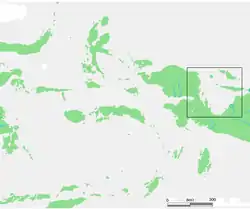
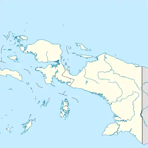
Cenderawasih Bay is a large bay to the northwest of the Indonesian province of Papua and east of the province of West Papua, between the Bird's Head Peninsula and the mouth of the Mamberamo River.
The bay is more than 300 kilometers wide. The coastline from Manokwari, in the northwest of the bay, to Cape d'Urville at the mouth of the Mamberamo is more than 700 kilometers long. To the south, the Wandammen peninsula heads north into the bay. Important places along the coast are Manokwari, Ransiki, Wasior and Nabire.
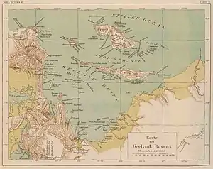
The Wamma River, Tabai River, Warenai River, and Wapoga River empty into the Bay.
History
The Dutch name of the bay was after the frigate De Geelvink with which Jacob Weyland sailed through the bay in 1705. The Dutch frigate was named after Geelvinck family.
Marine National park
Teluk Cenderawasih National Park is located in the Teluk Cenderawasih. In the Cenderawasih Bay extensive coral reefs exists. Parts of the area have been declared a protected marine reserve of 1.5 million hectares, the largest natural park in Southeast Asia. The western part of the bay was declared a marine national park in 2002.
Islands
In the bay are Biak, the Padaido Islands, Supiori and Numfor (Numfoor), the archipelago that was formerly known as Schouten Islands. Further south in the bay is the 140 kilometer long island of Japen (Yapen). Smaller islands in the bay are Num ( Pulau Num ), Rumberpon, Waar (or Meoswaar), Roon and Kurudu. The Mapia Islands lie to the north, and south of Palau.
West Papua Province
- Auri Islands archipelago (Kepulauan Auri)
- Meos Waar
- Rumberpon
- Roon Island
- Meos Angra
Papua Province
- Biak Islands (aka Schouten Islands):
- Yapen Islands
- Yapen
- Mios Num
- Kaipuri
- Ambai Islands (Kepulauan Ambai)
- Kuran Islands (Kepulauan Kuran)
- Moor Islands archipelago (Kepulauan Moor)
See also
- Bays of Indonesia
- Cenderawasih languages
References
| Wikimedia Commons has media related to Cenderawasih Bay. |
- Teluk Sarera: Indonesia National Geospatial-Intelligence Agency, Bethesda, MD, USA
Indonesian seas | |
|---|---|
| Ocean | |
| Sea | |
| Strait |
|
| Gulf | |