Natuna Sea
The Natuna Sea (Indonesian: Laut Natuna) is an extensive shallow sea located around the Natuna Regency, extended from south of the Riau Islands, east of the Lingga Regency and west of Borneo, to the Bangka Belitung Islands. The islands of the Badas and Tambelan Archipelago are located at its center. Mostly located within Indonesian territorial waters, this sea is the southernmost portion of the South China Sea, and geologically is the part of Sunda Shelf. It communicates with the Java Sea to its southeast via the Karimata and Gaspar Strait east and west of Belitung, and with the Strait of Malacca to the west via the Berhala and Singapore Strait.[1][2]
| Natuna Sea | |
|---|---|
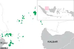 The Natuna Sea surrounding the Riau Islands province. | |
 Natuna Sea | |
| Coordinates | 1°N 107°E |
| Type | Sea |
| Native name | Indonesian: Laut Natuna |
| Basin countries | Indonesia |
The International Hydrographic Organization (IHO), in its Limits of Oceans and Seas, 3rd edition (1953), does not list a Natuna Sea. Instead, the area encompassed by the Natuna Sea is considered the southern portion of the South China Sea.[3] The 1986 draft of the IHO's Limits of Oceans and Seas proposed the Natuna Sea, which extends south from the Natuna and Anambas Islands to the Belitung Islands.[4] However, the 1986 draft edition was never approved.
Extent
The chains of Anambas and Natuna Islands created arch that connects southeastern tip of Malay peninsula to western tip of Borneo. This creates the northern boundary of Natuna Sea. While on the south, the southeast coast of Sumatra, the Lingga Islands, Bangka and Belitung islands creates its southern boundary and its opening to Karimata Strait and Java Sea.
Geography
Just like South China Sea, Natuna Sea is a marginal part of Pacific Ocean. Natuna sea contains numbers of archipelagos, including:
- Natuna Islands in Natuna Regency
- Greater Natuna Archipelago in Natuna Regency
- South Natuna Archipelago in Natuna Regency
- Anambas Archipelago in Anambas Islands Regency
- Lingga Archipelago in Lingga Regency
- Tambelan Archipelago in Bintan Regency
- Riau Archipelago
All of these archipelagos are administrated within Riau Islands province.
North Natuna Sea

In July 2017, Indonesia renamed the northern reaches of its exclusive economic zone in the South China Sea as the "North Natuna Sea", which is located north of the Indonesian Natuna Regency, bordering southern Vietnam's exclusive economic zone.[5][6] The North Natuna Sea is located between the Natuna Islands and Cape Cà Mau on the southern tip of the Mekong Delta in Vietnam.
References
- Natuna Sea and Sarawak Basin
- "Natuna Sea". The Diplomat.
- "IHO Publication S-23, Limits of Oceans and Seas, 3rd Edition 1953" (PDF). IHO. Retrieved 2020-02-10.
- "IHO Publication S-23, Limits of Oceans and Seas, Draft 4th Edition, 1986". IHO. Archived from the original on 2016-04-12. Retrieved 2017-07-17.
- Tom Allard; Bernadette Christina Munthe (14 July 2017). "Asserting sovereignty, Indonesia renames part of South China Sea". Reuters.
- "Indonesia Renames Its Portion of the S. China Sea". The Maritime Executive. 14 July 2017.
Indonesian seas | |
|---|---|
| Ocean | |
| Sea | |
| Strait |
|
| Gulf | |
