Pollokshaws
Pollokshaws (Scots: Powkshaws) is an area on the South side of the city of Glasgow, Scotland. It is bordered by the residential neighbourhoods of Auldhouse to the east, Eastwood and Hillpark to the south and Shawlands to the north, with the Glasgow South Western Line railway and the open lands of Pollok Country Park to the west. The White Cart Water flows through the area.[1]
Pollokshaws
| |
|---|---|
.jpg.webp) Pollokshaws Burgh Hall | |
 Pollokshaws Location within Glasgow | |
| OS grid reference | NS562656 |
| Community council |
|
| Council area | |
| Lieutenancy area |
|
| Country | Scotland |
| Sovereign state | United Kingdom |
| Post town | GLASGOW |
| Postcode district | G43 1 |
| Dialling code | 0141 |
| Police | Scotland |
| Fire | Scottish |
| Ambulance | Scottish |
| UK Parliament | |
| Scottish Parliament | |
The housing stock mostly consists of some sandstone tenement housing and modern brick tenement-style buildings. Eight tower blocks formerly stood in an area known as the Shawbridge Corridor; the final block was demolished in March 2016.
According to the 2001 Census, Pollokshaws had a population of 4,295. Its residents are a mixture of working class and middle class social groups, and the area also had a large South Asian community.
History
Pollokshaws was originally a village predominantly dedicated to weaving in the 17th century. A group of Flemish weavers were brought to the area in the 19th century by the landowners, the Maxwells of Pollok, on account of their exceptional weaving skills.[2]
Pollokshaws was a burgh of Renfrewshire until 1912 when it was annexed to the City of Glasgow.[3][4][5] Though it had been an industrial area, this changed in 1957 when it was proposed as the second Comprehensive Development Area in Glasgow (the first was Hutchesontown). The area was demolished and rebuilt anew.[6]

.jpg.webp)
A large number of tower blocks were built in the 1960s, and later demolished between 2008 and 2016 in the Shawbridge Corridor regeneration.[3] The areas where these blocks were will have a mix of social and private housing. The blowdowns of the first two towers in July 2008 was filmed in detail by an American company and can be seen as part of the documentary series "The Detonators".
Landmarks
Pollokshaws Burgh Hall on Pollokshaws Road, built in 1895–98 by architect Robert Rowand Anderson in the Scots renaissance style, was originally the municipal headquarters of the independent burgh before passing into the ownership of Glasgow Corporation following annexation. Now a Category A listed building, it was closed by the council in the 1990s but subsequently reopened for community use by a charitable trust.[7][8]
The Round Toll is a circular building now located on the central island of the roundabout of the same name. Built around 1820 as a tollbooth, it is the only surviving example of this type of building in the area, others having been lost to road development, and a rare example of an older building in Pollokshaws following 20th century slum clearance and redevelopment. It is now Category B listed. Following the abolition of road tolls in the 1880s it served as a carriage hire premises, a pub, and latterly as a private house up until the 1950s. It was subsequently used for council storage but is now vacant and isolated on the roundabout.[9]
Sport
The Pollokshaws Races, an informal horse racing event staged annually from around 1750 until 1883, took place on a racecourse to the southwest of the village, on land now occupied by Kennishead Road and Cowglen Golf Club. The races initially developed in conjunction with the local holiday, the Pollokshaws Fair, and were viewed more as an excuse for drinking and socialising rather than a serious sporting event.[10]
Pollok F.C.'s Newlandsfield Park is in the area, adjacent to Pollokshaws East railway station.
Pollokshaws Bowling Club was established in 1854 and has been based in Pollok Country Park since 1954. The land was donated by Sir John Stirling-Maxwell. The club celebrated its 150th anniversary in 2004, and were honoured with a civic reception in the Glasgow City Chambers.
Notable people
- Elizabeth 'Betty' Burns - Illegitimate daughter of Robert Burns is buried in the Kirk Lane Cemetery.
- Gilbert Burns Begg is buried in the Kirk Lane Cemetery. Nephew of Robert Burns as the son of his sister Isabella Burns Begg
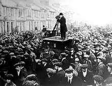
- John MacLean - early 20th century socialist
- Alex Norton - actor
- Bobby Collins - footballer (Celtic, Leeds United, Pollok F.C.)
- James Maxton - political activist
- Bobby Evans - footballer (Celtic)
- James Tassie - 18th century gem engraver
- Frankie Boyle - comedian[11]
See also
References
- Bogle's Bridge (Glasgow School of Art Archives, 1889), The Glasgow Story
- "Eye Spy Glasgow: In memory of the "Queer Folk"". Evening Times.
- Pollokshaws & Auldhouse illustrated guide, Scotcities
- Pollokshaws Panorama (Glasgow City Archives, Department of Architectural and Civic Design, 1958), The Glasgow Story
- Pollokshaws Townhouse (Pollok House, 1830), The Glasgow Story
- Clock Tower, Pollokshaws (Mitchell Library, Glasgow Collection, Bulletin Photographs, 1982), The Glasgow Story
- Historic Environment Scotland. "2025 POLLOKSHAWS ROAD AND BENGAL STREET, POLLOKSHAWS BURGH HALL (Category A Listed Building) (LB33953)". Retrieved 6 August 2020.
- "About". Pollokshaws Burgh Hall. Pollokshaws Burgh Hall Trust. Retrieved 6 August 2020.
- Historic Environment Scotland. "1 BARRHEAD ROAD, JUNCTION WITH POLLOKSHAWS ROAD AND NETHER AULDHOUSE ROAD, TOLL HOUSE FORMERLY 1 CROSS STREET (Category B Listed Building) (LB33915)". Retrieved 6 August 2020.
- O'Brien, Ged (2010). Inglis, Simon (ed.). Played in Glasgow: Charting the Heritage of a City at Play. London: Malavan Media. p. 79. ISBN 9780954744557.
- Jeffries, Stuart (19 December 2009). "Frankie Boyle lays into celebrity memoirs as his own is a surprise hit" – via www.theguardian.com.
External links
 Media related to Pollokshaws at Wikimedia Commons
- Pollokshaws Heritage Group for a full history of Pollokshaws
- Pollokshaws Heritage Trail, Pollokshaws Heritage Group / Glasgow City Council
| Authority control |
|
|---|