Porto Torres
Porto Torres (Sassarese: Posthudorra, Sardinian: Portu Turre) is a comune and a city of the Province of Sassari in north-west of Sardinia, Italy. Founded during the 1st century BC as Colonia Iulia Turris Libisonis, it was the first Roman colony of the entire island. It is situated on the coast at about 25 kilometres (16 mi) east of Capo del Falcone and in the center of the Gulf of Asinara. The port of Porto Torres is the second biggest seaport of the island, followed by the port of Olbia. The town is very close to the main city of Sassari, where the local university takes office.
Porto Torres
Posthudòrra | |
|---|---|
| Città di Porto Torres | |
City of Porto Torres | |
 Flag  Coat of arms | |
_-_2016.svg.png.webp) The territory of the comune (in red) inside the Province of Sassari | |
Location of Porto Torres 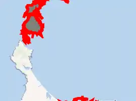
| |
 Porto Torres Location of Porto Torres in Sardinia 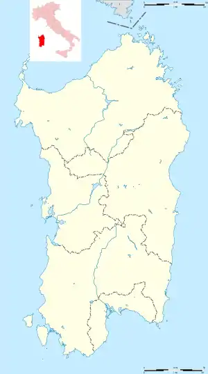 Porto Torres Porto Torres (Sardinia) | |
| Coordinates: 40°50′N 8°24′E | |
| Country | Italy |
| Region | Sardinia |
| Province | Sassari (SS) |
| Founded | 46 b.C (Roman settlement) 11 June 1842 (comune) |
| Frazioni | Li Lioni, Asinara, Fiume Santo, Platamona |
| Government | |
| • Mayor | Massimo Mulas (Progetto Turritano, PD, Italy in Common) |
| Area | |
| • Total | 104.41 km2 (40.31 sq mi) |
| Elevation | 17.00 m (55.77 ft) |
| Population (31-01-2020)[2] | |
| • Total | 22,134 |
| • Density | 210/km2 (550/sq mi) |
| Demonym(s) | Turritani, Bainzini or Portotorresi |
| Time zone | UTC+1 (CET) |
| • Summer (DST) | UTC+2 (CEST) |
| Postal code | 07046 |
| Dialing code | 079 |
| ISTAT code | 090058 |
| Patron saint | St. Gavinus, St. Proto, St. Gianuario |
| Saint day | 30 of May |
| Website | Official website |
.jpg.webp)


.JPG.webp)
.JPG.webp)
Toponymy

Historically the settlement was founded with the Latin name "Colonia Iulia Turris Libisonis", composed with Colonia (name of the roman settlements) Iulia (name of the Julia gens) Turris (litt. "tower", referred probably to a nuraghe built not so far from the town or to the Monte d'Accoddi) and Libisonis (referred to Lybia, probably because in the same are there was a Phoenician trading outpost. "Lybia" is the ancient name of the entire northern coast of Africa).[3] After the fall of the Western Roman Empire the town was known simply as "Turris". During the Middle ages during the Judicate of Logudoro the name was corrupted with "Torres" and after, during the Aragonese period, the town was known simply with the Catalan name of "Lo Port" (The port). During the Savoy reign it was known with the name of Portotorre (Porto+Torre; "Towerport").
Until the 1960s the town was commonly known as "Portotorres", and only after the official recognition of the status of city the name has officially changed in Porto Torres.[4]
History
The Miocene
In the frazione of Fiume Santo in 1994 has been find a lot of animal fossils presumably dated at the Miocene. Some 8/9 millions years old rests of Oreopithecus bambolii has been find in the same area. The discovering has started casually thanks to some hobbyist paleontologists that have noticed after some maintenance works in the near thermal power station the presence of some fossils in the excavation debris. In the area has been individuated 15 vertebrate species like giraffes, crocodiles, turtles, suidae and Mustelidae. Most of these animals like the Umbrotherium azzarolii were herbivorous, but some others like the Indarctos anthracitis were omnivores.[5]
Prehistory
Ancient human presence in the municipal territory of Porto Torres is certified thanks to many necropolis in the area. The altar of Monte d'Accoddi (very near to the town but in the municipality of Sassari) witness the human presence in that area during this ages.
Bronze and Nuragic Age
Finds dated at this ages has been find in the Necropolis of Su Crucifissu Mannu. In this necropolis has been find two skulls with the presence of some sort of surgical procedure probably practiced in order to heal issues like migraines and tumors. Another theory is that this surgical procedure has been practiced for religious and/or magical purposes. Many nuraghes belong to this ages, and nowadays only 7 of these structures are in a well state of preservation. The Domus de Janas of Andreolu also witness the presence of the Nuragic civilizzation.
Roman period (46 b.C.- 455 a.C)
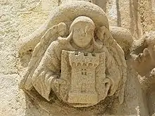
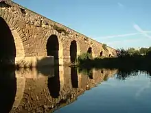
In ancient times, Turris Libisonis was one of the most considerable cities in Sardinia.[6] It was probably of purely Roman origin, founded apparently by Julius Caesar, as it bore the title Colonia Julia.[7] Pliny described it as a colony, the only on the island in his time, suggesting that there was previously no town on the spot, but merely a fort or castellum. It is noticed also by Ptolemy and in the Itineraries, but without any indication that it was a place of any importance.[6] The ancient remains still existing prove that it must have been a considerable town under the Roman Empire. According to inscriptions on ancient milestones, the principal road through the island ran directly from Caralis (Cagliari) to Turris, a sufficient proof that the latter was a place much frequented.[6] Indeed, two roads, which diverged at Othoca (modern Santa Giusta) connected Caralis to Turris, the more important keeping inland and the other following the west coast.[7] It was also an episcopal see during the early part of the Middle Ages.[6] There exists also the remains of a temple (which, as we learn from an inscription, was dedicated to Fortune, and restored in the reign of Philip), of thermae, of a basilica and an aqueduct, as well as a bridge over the adjoining small river, still called the Fiume Turritano.
After the Roman fall
The ancient city continued to be inhabited till the 11th century, when the greater part of the population migrated to Sassari, about 15 kilometres (9 mi) inland, and situated on a hill.[6] It was partly under Genoese hands before, in the early 15th century, it was conquered by the Aragonese. After the Spanish rule it was part of the Kingdom of Sardinia.
Torres was separated from the comune of Sassari in 1842. At the time the area which had been built around the basilica of San Gavino joined the fishermen's community near the port to form the new Porto Torres. On 10 May 1942 Benito Mussolini visited the town.[8] On 18 April 1943 the city was bombed by the Allies.[9]
Geography
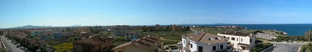
Porto Torres' territory is situated on the north-west part of Sardinian Coast.
The extension of municipality is almost 10,200 hectare and is subdivided in two parts, with almost the same extension. One part includes the city, the industrial area and the Roman ruins; the latter is formed by the Asinara island with the smaller Isola Piana. This part of territory is, since 1997, a national park.
The morphology of "city part" is flat; the area of Porto Torres and the rest part of north-west Sardinia is characterized by a Nurra flat, there are some hill formations in the middle of the flat. Part of this hill formation is in Porto Torres' territory and the highest elevation of it is Monte Alvaro with a height of 342 m.
The communal territory is crossed by two rivers, Rio Mannu and Fiume Santo. The first draws the edge of Porto Torres territory on west, while instead the latter flows near the city and was used as a fluvial way as early as the Roman age.
Demographics
The town was considered more or less like a hamlet until 1960s. In that period, thanks to the industrialization, the population has increased rapidly until the 1980s, when the local petrochemical industry managed by the "SIR - Società Italiana Resine" owned by Angelo Rovelli has entered in a deep financial crisis.[10]
| Year | Pop. | ±% |
|---|---|---|
| 1861 | 2,025 | — |
| 1871 | 2,248 | +11.0% |
| 1881 | 3,228 | +43.6% |
| 1901 | 4,225 | +30.9% |
| 1911 | 5,154 | +22.0% |
| 1921 | 5,792 | +12.4% |
| 1931 | 7,116 | +22.9% |
| 1941 | 7,311 | +2.7% |
| 1951 | 9,118 | +24.7% |
| 1961 | 11,199 | +22.8% |
| 1971 | 16,230 | +44.9% |
| 1981 | 21,990 | +35.5% |
| 1991 | 21,264 | −3.3% |
| 2001 | 21,064 | −0.9% |
| 2011 | 22,391 | +6.3% |
| Source: ISTAT | ||
Economy
Tourism
Starting in 2008, tourism has become a very important activity for the economy of the city. The town have several attractions, both natural and anthropic. The main attraction is the Asinara national park. The Aragonese seaport tower is considered the symbol of the city and because of this it is one of the main tourist attractions. Other main attractions are the Roman bridge of Riu Mannu and the Basilica of Saint Gavinus. Due to the decline of the industrial sector, the tourist sector has started to become the leading sector of the local economy (despite the local industrial zone, that importance for the city remains high).
Industry
Chemical industries support the modern economy of Porto Torres. Fiume Santo, a 1,040 MW power station owned by E.ON, is 5 to 10 kilometres (3 to 6 mi) west from the city, in the municipality of Sassari.[12]
Plans related to industrial conversion are in progress in Porto Torres, where seven research centers are developing the transformation from traditional fossil fuel related industry to an integrated production chain from vegetable oil using oleaginous seeds to bioplastics.[13]
Governance
| In charge | Name | Political alliance | Role | Notes |
|---|---|---|---|---|
| 20 July 1988 24 June 1990 |
Rodolfo Cermelli | Christian Democracy | Mayor | [14] |
| 27 July 1990 28 June 1993 |
Giacomo Rum | Italian Socialist Party | Mayor | [14] |
| 28 June 1993 12 May 1997 |
Alfredo Dessì | PRC, Democratic Party of the Left, PSd'Az | Mayor | [14] |
| 12 May 1997 28 May 2001 |
Eugenio Cossu | PRC, Democratic Party of the Left, FdV | Mayor | [14] |
| 28 May 2001 01 February 2005 |
Gilda Usai Cermelli | FI, AN, civic list, CCD, CDU | Mayor | [14] |
| 23 May 2005 15 June 2010 |
Luciano Mura | Democrats of the Left, PSd'Az, DL, Italian Democratic Socialists, PCI, PRC | Mayor | [14] |
| 15 June 2010 10 February 2015 |
Beniamino Luigi Scarpa | Many civic lists, IDV | Mayor | [14] |
| 18 June 2015 09 November 2020 |
Sean Christian Wheeler | Five Star Movement | Mayor | [14] |
| 09 November 2020 in charge |
Massimo Mulas | Progetto Turritano, PD, Italy in Common | Mayor | [14] |
Culture
Festivals
At the end of August it took place the festival called "Suoni & Sapori", a festival that put together the tasting of local food and the listening of music composed by local artists.[16] "La giornata dello sport" is an annual local festival that promote the sport activity for both children and adults.[17] The "Festival Internazionale di Musiche Polifoniche Voci d’Europa" organized by the local polyphonic choir is an annual music festival of the town.[18] The "Fisherman's regatta" is a competition where the fishermen try to fishing using only traditional early 20th-century equipment like rowing boats without any use of modern tools like the GPS tracker.[19]
Main sights
Churches
.JPG.webp)
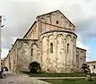
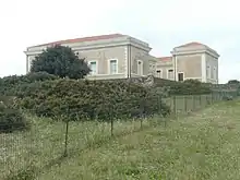
- Built using only hardstones like marble, porphyry and granite, is the largest Romanesque church in Sardinia built between 1065 and 1080 above the hill of "Monte Angellu" in one of the historical neighborhood of the town. The basilica was erected in the memory of St. Gavinus, St. Protus and St. Gianuario, beheaded during the 303 a.C under the governance of the emperor Diocletian and Maximian. Instead of the usual western facade and eastern apse, the cathedral sports two apses. The crypt holds several Roman sarcophagi.It was the main cathedral of the roman catholic archdiocese of Sassari until 1441.
- Church of Beata Vergine della Consolata (1826)[20]
- Neoclassic church built by the architect Giuseppe Cominotti (the same person who also built the Marquess's palace) in 1826. It was the main church of the historical seaport neighborhood, distinguished from the rural neighborhood of "Monte Angellu" situated near the Basilica of St.Gavinus.
- Church of San Gavino a Mare (1850)[21]
- Also known as "Balai vicino" in order to distinguish it from the very similar church of Santu Bainzu Ischabizzaddu, it is built near the beach of Balai. In that place St. Gavinus, St. Proto and St. Gianuario has been buried after the execution, inside the building there are the three loculi of the saints.
- Church of Santu Bainzu Ischabizzaddu[22]
- Also known as "Balai lontano" in order to distinguish it from the very similar church of San Gavino a Mare, it is built in the place where the three saints has been beheaded. Built with limestone, it seems to be a rebuild of a more ancient building. The name, literally "Church of the beheaded St. Gavinus " is because of, following the folk custom, in that place on the 25 of October 303 d.C., St. Gavinus was executed and, two days later, Proto and Gianuario did the same epilogue.
- Monumental cemetery of Cala D’Oliva[23]
- An ancient cemetery in the island of Asinara. The historical cemetery of Cala d'Oliva host the ancestors of the inhabitants of Stintino; the town founded in 1885 by the residents of Cala d'Oliva after the institution of the exile colony in the island of Asinara, which forced them to abandon their homes of their historical settlement.
- Austro-hungarian chapel of St Ephysius and St Gavinus (1915)[24][25]
- Built by the austro-hungarians POW imprisoned in the exile colony of the Asinara in the period between 1915 and 1916. Artistically it was decorated by the hungarian prisoner György Nemess.
- Italian cemetery of Campo Faro (1916)[26]
- During the WWI the island of Asinara was also a lazaretto for the italian soldiers affected by cholera during the campaign in Albania. In that period took place the history of the bolognese soldiers of the "Brigata Savona" died before they can reach the island during their transport in the hospital ship "Re d'Italia". In order to distinguish the italian soldiers corpses from the austro-hungarian it was built a cemetery in the area of "Campo faro" and it was called "Italian cemetery".
- Austro-hungarian Ossuary (1936)[26]
- An ossuary built in 1936 by the will of the Austrian government in order to keep the corpses of all the 7048 austro-hungarian unidentified soldiers died during the detention in the penal colony during the WWI because of typhoid fever and cholera.
Civil architectures
In the Porto Torres's comprehensive planning there are many civil buildings both of private propriety and owned by the comune that are considered historically significant.[4] These buildings witness the urban and the economic development of the city through the centuries until the 1960s; period of the local golden age of the industrial development thanks to the Italian economic miracle. Many of these architectures, especially the industrial ones, are not fully restored and visitable.
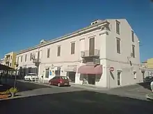
- Marquess's palace, neoclassical palace built by Giuseppe Cominotti, the same architect of the not so far church of the "Beata vergine della consolata";[27]
- Seaport museum (1872), an example of the industrial architecture of the 19th century. Originally used as a train station, now it is a museum;[28]
- Junior school E. De Amicis (1912), An historical full-working school building built by engineer Eugenio Serra. It is a full architectural example of the 19th-century Italian schools;[29]
- Ferromin S.A. industrial complex, built in the early 20th century, it has been the main industrial complex of the town for decades until the liquidation of the "Societá Anonima Ferromin" in the 1960s;[30][31]
- Porto Torres Marittima station (1872), late 19th-century building, terminal of the "Ozieri-Chilivani-Porto Torres Marittima" railway;
- Industrial complex "Ex-cementeria Alba" (1957), built during the industrial golden age by the engineer Messina, it is a pure example of industrial archaeology;[32]
- Industrial complex "Ex ferriera sarda" (1959), another example of the industrialization of north Sardinia, built by the influent entrepreneurs family of the Salis;[33]
- Agricultural consortium of Via Sassari, An old consortium building that witness the agricultural past of the city. The historical storage buildings known as "I Granai" are now used as a mall;
- Hamlet of Cala d'Oliva, located in the Asinara it is the historical settlement abandoned at the end of the 19th century;
- Lighthouse of Punta Scorno (1854), located in the Asinara, it is an ancient full-working lighthouse, one of the most ancient lighthouses of Sardinia;
- Stoplight station of Punta Scorno;
- Royal Palace of Cala reale, the summer residence of the Savoy during their residence in the Asinara;
- Hospital of Cala Reale;
- Healthcare marittime quarantine station of Cala Reale, building used both as a lazaretto and a storage for the local healthcare.
Military architectures
- Air-raid shelter "ex caserma dei carabinieri" (1943)[34]
- During the early WWII all the air-raid shelters in the town was barely used until may 1943, when the city was heavily bombed by the RAF. That air raid bombing, the worst that the city has suffered in the whole war period, was commonly remembered as "Palm Sunday bombing". For a long period of time this air raid shelter was left abandoned and in a heavy state of decay (same thing was for the air raid shelter "scuole de Amicis"), only recently has been restored and opened to the public.
- Air-raid shelter "scuole De Amicis"[34]
- Situated under the 1900s junior school E. de Amicis: like many others air-raid shelters of the town, it was used during the world war II in order to protect the civilians from the several air-raids of the time. In the present days it is used as an exposition gallery.
- Artillery outpost of the roman bridge n° SR414 (1873)[35]
- An outpost used until the second world war composed with several military installations
- Castle of the Asinara[36]
- Also known as the "Castellaccio" it is an ancient medieval castle in the island of the Asinara. In the present days it is used as a fire protection outpost by the Asinara national park administration.
- Spanish towers (1323-1720)
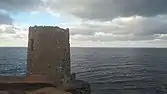
- Aragonese tower (1325)[37]
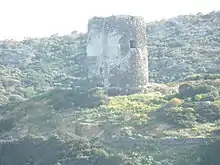 Tower of Cala d'Oliva
.JPG.webp) Tower of Abbacurrente
Tower of Abbacurrente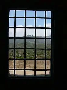 View from one of the penitentiary's cell
 - Tower of Abbacurrente (1571)
- Tower of the Finance (1525)
- Tower of Trabuccato (1609)
- Tower of Cala d'Oliva (1611)
- Tower of Cala d'Arena (1611)
- Aragonese tower (1325)[37]
- Asinara penitentiary complex (1885)[38]
- Known as the "Italian Alcatraz", it is became famous in Italy after a revolt happened during the 2nd of October 1973. In the penitentiary of the Asinara has been detained the most dangerous criminals of the Sicilian Mafia, the Camorra, the Anonima Sarda ant the Red brigades. In more than one hundred years of activity the only prisoner who successfully escaped from the island penitentiary was the italian criminal Matteo Boe. During the WWI and the WWII it was used as an exile colony for thousands of POW and political prisoners. The penitentiary complex is composed by several sections located all around the island:
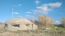
- Penitentiary section "Bunker of Cala d'Oliva"
- Penitentiary section of Cala d'Oliva
- Penitentiary section of Fornelli
- Penitentiary section of Santa Maria
- Penitentiary section of Tumbarino
- Penitentiary section of Campu Perdu
- Penitentiary section of Campo Faro
- Penitentiary section of Stretti
- Penitentiary section of Trabuccato
- Penitentiary section of Case Bianche
- Penitentiary section of Elighe Mannu
Archaeological sites
- Nuraghes
- Nuraghe Biunisi
- Nuraghe Monte Elva
- Nuraghe Margone
- Nuraghe Nieddu
- "Turris Libisonis" Archaeological park
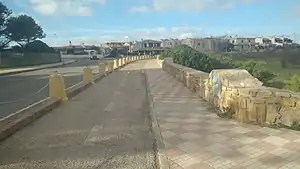
- Roman bridge of Rio Mannu[39]
- Palace of the "Re Barbaro" and domus of Orpheus[40]
- Baths of Maetzke
- Baths of Pallottino (III secolo d.C)
- Mosaics's Domus (I secolo d.C.)
- Other sites
- Necropolis of Su Crucifissu Mannu
- Domus de Janas of Campu Perdu (Asinara)
- Hypogeum et Columbarium of Tanca Borgona (II secolo d.C.)
- Hypogeum of Scoglio Lungo
Other
Natural areas
- Protected areas
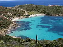
- Asinara national park;[38]
- Marine protected area of the Asinara;[38]
- Sanctuary of the marine mammals.[38]
- Beaches
.jpg.webp)
- Beach of Fiume Santo
- Beach of Renaredda
- Beach of the Scogliolungo
- Beach of Acque Dolci
- Beach of Balai
- Beach of the Scoglio Ricco
- Il Ponte
- Beach of Abbacurrente
- Beach of Farrizza
- Main parks
- San Gavino's park;
- Robert Baden-Powell's park;
- Pinewood "La Farrizza" .
Sports
Football
Main football clubs:
- Porto Torres Calcio (Serie D)[41]
- Turris
- Polisportiva Dilettantistica Quartieri Riuniti (A.k.a. "Quartieri Riuniti")
- Turritana
Tennis
Main association:
- A.S.D. Tennis Club Porto Torres
Basket
Main associations:
- GSD Porto Torres
- CMB Porto Torres
- Silver Basket Porto Torres
- Balai Basket
Martial arts and combat sports
There are many boxing clubs and martial arts schools. Sports like Karate shotokan, MMA, Boxing, Jujitsu, Krav-Maga and Self-defense are very appreciated and practiced by some part of the citizens.
Equestrianism
Right below the ancient Roman bridge Porto Torres has a riding hall where the local A.S.D. Centro Ippico Equitazione Porto Torres practice horse riding[43].
Sport facilities
- Sports area "Cittadella dello sport"[44]
- A 67.000 m² area which offer many sports.
- Main area ("Campo sportivo comunale" or "Stadio comunale")
- It is a multi-purpose stadium mainly composed with:
- 1 football pitch of 60 x 105 meters (home ground of the A.C. Porto Torres)
- Running track
- Shot put area
- Discus throw area
- Hammer throw area
- Javelin throw area
- Pole vault area
- High jump area
- Other areas
- Boxing club "Alberto Mura"
- Tennis club
- 1 football pitch of 105 x 603 meters
- 1 football pitch of 100 x 60 meters
- Palasport "Alberto Mura"[44]
- A sport facility with a capacity of 1.600 people mainly used as an indoor basketball court.
- Skate park
- A 1.800 m² skateboard park with a bank ramp of 20°, a square-rail, a pyramid ledges and a quarter pipe.
- Football pitch "Angelo Occone"[45]
- Football pitch of 100 x 60 meters situated not so far from the town hall.
- Other
- Artificial pine forest[46]
- Called "Pineta la Farrizza", "Pineta Abbacurrente" or "Pineta Balai lontano", it is composed mainly of stone pines.
- Bicycle Path[47]
- Starting from "Piazza eroi dell'onda" and finishing in the plaza of "Balai lontano", it offers a panoramic view of the sea.
Transport
Main roads
| Road | Connection | Type | Notes |
|---|---|---|---|
| Strada Statale 131 "Carlo Felice" | Porto Torres - Cagliari |  |
[48] |
| Strada provinciale 93 | Porto Torres - La Corte (SS) | [48] | |
| Strada Provinciale 81 | Porto Torres - Platamona | [48] | |
| Strada Provinciale 57 | Porto Torres - Palmadula (SS) | [48] | |
| Strada Provinciale 42 "Dei due mari" | Porto Torres - Alghero | [48] | |
| Strada Provinciale 34 | Porto Torres - Stintino | [48] | |
| Strada Provinciale 25 | Porto Torres - Sorso | [48] |
Train stations
.jpg.webp)
A railway operated by Trenitalia connects the town with Sassari and the rest of the island. The town has two train stations, one built at the end of the 20th century (considered as the main station) and one smaller and more historical built during the 19th century (referred as "Porto Torres marittima").
Seaport
.jpg.webp)
The existing port of Porto Torres, which is almost wholly artificial, is based in great part on Roman foundations. In the north-west of Sardinia, the harbor of Porto Torres is the biggest.[49] The city has connections with the rest of the Italy, of Spain and France. Not so far from the harbor there is the Maritime Terminal (Stazione marittima). In the same area there is built the new passenger terminal (Terminal passeggeri; the building is still under construction). From the seaport there is also available a connection for the island of Asinara.
- Destinations:
| Company | Route | Frequency | Notes | ||
|---|---|---|---|---|---|
| Tirrenia Grandi Navi Veloci |
Genova | Daily (winter) / Double-daily (summer) [with Tirrenia] Three times at week [with G.N.V.] |
[50] | ||
| Corsica Ferries - Sardinia Ferries | Ajaccio Porto Vecchio Livorno Toulon |
Weekly | [50] | ||
| Grimaldi Lines | Civitavecchia | Five times at week | [50] | ||
| Barcelona | Five times at week | [50] | |||
| Compagnie méridionale de navigation | Marsiglia | weekly | [50] | ||
| Propriano | weekly | [50] | |||
| Delcomar | Asinara | Daily (Summer and Spring) Three times at week (Winter and Autumn) |
[51] | ||
Public transport
Porto Torres belong to the metropolitan network of north Sardinia (lit. "Rete metropolitana del nord Sardegna"). Due to this, the city is well-connected with all nearly towns via intercity autobus thanks to the ARST. Local rides are managed by the local public transport agency (A.t.p. Sassari).
Education
School
The town has many state high-schools and several state primary schools in its territory.[52][53]
In the urban territory there is also a music school named in memory of the Italian songwriter Fabrizio de Andrè.[54]
Due to the proximity to the city of Sassari and thanks to the intercity lines managed by ARST[55] for the citizens is very easy to reach the near University of Sassari.
Libraries
Public library "Antonio Pigliaru" is the only library of the town.
Media
Radio stations
- Radio del Golfo[57]
Cinematography
- Bonifacio Angius - "Ovunque proteggimi" (2018).[58]
Notable People
Footers
References
| Wikimedia Commons has media related to Porto Torres. |
- "Superficie di Comuni Province e Regioni italiane al 9 ottobre 2011". Istat. Retrieved 16 March 2019.
- All demographics and other statistics: Italian statistical institute Istat.
- "A. Mastino-C. Vismara, Turris Libisonis" (PDF). www.sardegnacultura.it (in Italian). 1994.
- "Historical research by the Liceo Scientifico Europa Unita of Porto Torres" (PDF). www.liceo-portotorres.it (in Italian). 2004.
- "Fiume Santo (Sardegna) — Italian Paleontological Society". paleoitalia.org (in Italian). Retrieved 2020-09-13.
-
 One or more of the preceding sentences incorporates text from a publication now in the public domain: Smith, William, ed. (1857). "Turris Libyssonis". Dictionary of Greek and Roman Geography. 2. London: John Murray. p. 1241.
 - One or more of the preceding sentences incorporates text from a publication now in the public domain: Chisholm, Hugh, ed. (1911). "Turris Libisonis". Encyclopædia Britannica (11th ed.). Cambridge University Press.
- "Mussolini a Porto Torres - Cinecittà Luce - Unesco". fondoluce.archivioluce.com (in Italian). Retrieved 2020-04-08.
- "Il bombardamento di 67 anni fa - La Nuova Sardegna". Archivio - La Nuova Sardegna (in Italian). Retrieved 2020-04-08.
- "ROVELLI, Angelo Nino Vittorio in "Dizionario Biografico"". www.treccani.it (in Italian). Retrieved 2020-09-09.
- "Statistiche demografiche ISTAT". demo.istat.it (in Italian). Retrieved 2020-09-09.
- "Fiume Santo Power Station (Thermoelectric Power Plant), Italy". www.power-technology.com. Retrieved 28 January 2011.
- "Versalis. Brochure istituzionale" (PDF). www.eni.com (in Italian).
- "Dipartimento per gli Affari Interni e Territoriali". amministratori.interno.gov.it. Retrieved 2020-09-09.
- Torres, Comune di Porto. "Porto Torres e Camposano: gemellaggio nel nome di San Gavino". Comune di Porto Torres (in Italian). Retrieved 2020-09-08.
- "Suoni & Sapori | VIII Edizione". Comune di Porto Torres (in Italian). Retrieved 2020-09-09.
- "Giornata dello sport 2019". Comune di Porto Torres (in Italian). Retrieved 2020-09-09.
- "Voci d'Europa 2019 | Evento di apertura". Comune di Porto Torres (in Italian). Retrieved 2020-09-09.
- "Regata del pescatore | XII edizione". Comune di Porto Torres (in Italian). Retrieved 2020-09-09.
- Littera, Marta. "Chiesa della B.V. della Consolata". Monumenti Aperti (in Italian). Retrieved 2020-09-09.
- "Chiesa di San Gavino a mare o Balai vicino". SardegnaTurismo - Sito ufficiale del turismo della Regione Sardegna (in Italian). 2015-11-20. Retrieved 2020-09-09.
- Torres, Comune di Porto. "Chiesa di Santu Bainzu Ischabizzaddu o Balai Lontano". Comune di Porto Torres (in Italian). Retrieved 2020-09-09.
- Hendel, Carlo (2019-07-30). "Il cimitero di Cala D'Oliva". Isola Asinara (in Italian). Retrieved 2020-09-09.
- "Sardegna DigitalLibrary - Cappella austro-ungarica di cala Reale". www.sardegnadigitallibrary.it (in Italian). Retrieved 2020-09-09.
- Hendel, Carlo (2019-01-23). "Cappella austro ungarica di Cala Reale". Isola Asinara (in Italian). Retrieved 2020-09-09.
- D-sign.it. "I cimiteri italiano ed austro-ungarico nell'isola dell'Asinara. - Storia e Memoria di Bologna". www.storiaememoriadibologna.it (in Italian). Retrieved 2020-09-09.
- Littera, Marta. "Palazzo del Marchese". Monumenti Aperti (in Italian). Retrieved 2020-09-09.
- Torres, Comune di Porto. "Museo del Porto". Comune di Porto Torres (in Italian). Retrieved 2020-09-09.
- Littera, Marta. "Scuola Elementare De Amicis". Monumenti Aperti (in Italian). Retrieved 2020-09-09.
- Littera, Marta. "Fornaci e area Ferromin". Monumenti Aperti (in Italian). Retrieved 2020-09-09.
- Sardegnaabbandonata. "Vecchie fornaci, Porto Torres | Sardegna Abbandonata" (in Italian). Retrieved 2020-09-09.
- Sardegnaabbandonata. "Alba Cementi, Porto Torres | Sardegna Abbandonata" (in Italian). Retrieved 2020-09-09.
- Sardegnaabbandonata. "Ferriera Sarda, Porto Torres | Sardegna Abbandonata" (in Italian). Retrieved 2020-09-09.
- "Porto Torres: rifugi antiaerei ripuliti da quintali di rifiuti". L'Unione Sarda.it (in Italian). 2020-03-02. Retrieved 2020-09-09.
- Littera, Marta. "Batteria antinave di Ponte romano". Monumenti Aperti (in Italian). Retrieved 2020-09-09.
- "Torri costiere - Fortezza Castellaccio | Porto Torres". www.sardegnaambiente.it (in Italian). Retrieved 2020-09-09.
- Torres, Comune di Porto. "Torre Aragonese". Comune di Porto Torres (in Italian). Retrieved 2020-09-09.
- "Parco Nazionale dell'Asinara". www.parcoasinara.org (in Italian). Retrieved 2020-09-09.
- Torres, Comune di Porto. "Ponte Romano". Comune di Porto Torres (in Italian). Retrieved 2020-09-09.
- Littera, Marta. "Area archeologica. Palazzo di Re Barbaro e Domus di Orfeo". Monumenti Aperti (in Italian). Retrieved 2020-09-09.
- "Portotorres - Calcio - Promozione, girone B - Sardegna - Stagione 2019/2020 - Scheda squadra". sardegna.diariosportivo.it (in Italian). Retrieved 2020-09-09.
- "FIDAL - Federazione Italiana Di Atletica Leggera". www.fidal.it (in Italian). Retrieved 2020-09-09.
- "EQUITAZIONE PORTO TORRES". PagineBianche (in Italian). Retrieved 2020-04-17.
- "Regione Autonoma della Sardegna". www.regione.sardegna.it (in Italian). Retrieved 2020-09-09.
- "Sardegnasport.it". www.regione.sardegna.it (in Italian). Retrieved 2020-09-09.
- "Pineta di La Farrizza". Comune di Porto Torres (in Italian). Retrieved 2020-09-09.
- "Pista ciclabile e pedonale". Comune di Porto Torres (in Italian). Retrieved 2020-09-09.
- "ViaMichelin : Percorsi, Mappe, Ristoranti, Traffico e Alberghi". www.viamichelin.it (in Italian). Retrieved 2020-09-08.
- "Arrivare in nave". Comune di Porto Torres (in Italian). Retrieved 2020-04-08.
- "Il porto di Porto Torres - Biglietti e rotte". iltraghetto.it (in Italian).
- "Delcomar - Asinara - Porto Torres". delcomar.it (in Italian).
- "Scuole dell'obbligo a Porto Torres". Comune di Porto Torres (in Italian). Retrieved 2020-04-06.
- "Liceo Scientifico "Europa Unita"". www.iispaglietti.edu.it (in Italian). Retrieved 2020-04-06.
- Torres, Comune di Porto. "Scuola Civica di Musica". Comune di Porto Torres (in Italian). Retrieved 2020-04-06.
- "ARST - - Servizi extraurbani TPL". arst.sardegna.it (in Italian). Retrieved 2020-04-06.
- "Periodici cittadini". Comune di Porto Torres (in Italian). Retrieved 2020-09-09.
- contini, valerio. "Rdg - Radio del Golfo". www.radiodelgolfo.net (in Italian). Retrieved 2020-09-09.
- "Ovunque proteggimi (Film)". MYmovies.it (in Italian). Retrieved 2020-09-09.
- "Demuro: "Canto il sole della mia terra"". www.lanuovasardegna.it (in Italian).
- "Alessandro Frau - Carriera - stagioni, presenze, goal". www.tuttocalciatori.net (in Italian). Retrieved 2020-09-09.
- "2 agosto 1975: Giuseppe Mura batte Giovanni Girgenti". 2Out.it - Seconds Out - Free Sport Magazine (in Italian). 2016-08-02. Retrieved 2020-09-09.
- "Andrea Parodi". www.fondazioneandreaparodi.it (in Italian). Retrieved 2020-09-09.
- "Scomparso il documentarista sardo Fiorenzo Serra". www.regione.sardegna.it (in Italian). Retrieved 2020-09-09.
| Authority control |
|---|