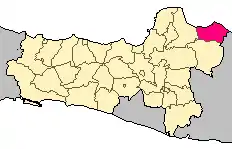
Rembang Regency
Rembang Regency (Indonesian: Kabupaten Rembang) is a regency (Indonesian: kabupaten) on the extreme northeast coast of Central Java Province, on the island of Java (bordering on the Java Sea) in Indonesia. The regency covers an area of 1,035.70 km2 on Java. Its capital city is Rembang.
Geography

It is a lowland, with a maximum elevation of about 70 metres (230 ft) above sea level.
The Solo River flows through its inland section.
The regency is crossed by the North Coast Road, an inter-province main road on the island.
Borders
Rembang Regency is bordered by:[1]
- North : Java Sea
- East : Tuban Regency in East Java Province
- South : Blora Regency
- West : Pati Regency
Population

At the 2010 Census it had a population of 591,359 people[2] and of 618,780 at the 2015 Census. The more recent official estimate (for mid 2016) gave a population of 624,081.[3]
Administrative districts
The regency is divided into fourteen districts (kecamatan), tabulated below with their areas and their populations at the 2010 Census,[4] together with the latest official estimates (for mid 2016).[5] The table also includes the number of administrative villages (rural desa and urban keluraham) in each district and its post code.
| Name | Area in km2 | Pop'n Census 2010 | Pop'n Estimate mid 2016 | No. of vill. | Post code |
|---|---|---|---|---|---|
| Sumber | 78.20 | 33,586 | 34,860 | 18 | 59253 |
| Bulu | 101.10 | 25,649 | 26,607 | 16 | 59255 |
| Gunem | 84.74 | 22,743 | 23,882 | 16 | 59263 |
| Sale | 109.02 | 35,756 | 37,584 | 15 | 59265 |
| Sarang | 93.83 | 60,063 | 64,122 | 23 | 59274 |
| Sedan | 86.35 | 51,143 | 53,948 | 21 | 59264 |
| Pamotan | 80.60 | 43,959 | 45,693 | 23 | 59261 |
| Sulang | 84.81 | 36,764 | 38,683 | 21 | 59254 |
| Kaliori | 61.17 | 38,615 | 40,672 | 23 | 59252 |
| Rembang (district) | 61.55 | 83,942 | 89,854 | 34 | 59211 -59219 |
| Pancur | 43.01 | 27,345 | 28,990 | 23 | 59262 |
| Kragan | 67.18 | 58,232 | 62,111 | 27 | 59273 |
| Sluke | 38.02 | 26,620 | 27,884 | 14 | 59272 |
| Lasem | 46.12 | 46,942 | 49,191 | 20 | 59271 |
| Totals | 1,035.70 | 591,359 | 624,081 | 294 |
Climate
Rembang has a tropical monsoon climate (Am) with moderate to little rainfall from May to October and heavy rainfall from November to April.
| Climate data for Rembang | |||||||||||||
|---|---|---|---|---|---|---|---|---|---|---|---|---|---|
| Month | Jan | Feb | Mar | Apr | May | Jun | Jul | Aug | Sep | Oct | Nov | Dec | Year |
| Average high °C (°F) | 31.1 (88.0) |
31.0 (87.8) |
31.3 (88.3) |
32.0 (89.6) |
32.0 (89.6) |
32.0 (89.6) |
32.3 (90.1) |
33.1 (91.6) |
34.2 (93.6) |
34.4 (93.9) |
33.7 (92.7) |
32.2 (90.0) |
32.4 (90.4) |
| Daily mean °C (°F) | 26.9 (80.4) |
26.9 (80.4) |
27.0 (80.6) |
27.4 (81.3) |
27.3 (81.1) |
26.9 (80.4) |
26.6 (79.9) |
27.0 (80.6) |
27.9 (82.2) |
28.4 (83.1) |
28.3 (82.9) |
27.4 (81.3) |
27.3 (81.2) |
| Average low °C (°F) | 22.7 (72.9) |
22.8 (73.0) |
22.8 (73.0) |
22.8 (73.0) |
22.6 (72.7) |
21.8 (71.2) |
20.9 (69.6) |
20.9 (69.6) |
21.6 (70.9) |
22.5 (72.5) |
23.0 (73.4) |
22.7 (72.9) |
22.3 (72.1) |
| Average rainfall mm (inches) | 263 (10.4) |
206 (8.1) |
197 (7.8) |
129 (5.1) |
105 (4.1) |
72 (2.8) |
35 (1.4) |
23 (0.9) |
36 (1.4) |
69 (2.7) |
138 (5.4) |
219 (8.6) |
1,492 (58.7) |
| Source: Climate-Data.org[6] | |||||||||||||
Lasem
During the colonial Dutch East Indies period, the area was known as Lasem.
The Han family of Lasem was a prominent Chinese immigrant family of colonial government bureaucrats and landlords in the area.[7]

References
- "JavaTourism.com – Java, Indonesia Travel and Tourism Information". Retrieved 2020-06-03.
- Biro Pusat Statistik, Jakarta, 2011.
- Badan Pusat Statistik, Jakarta, 2020.
- Biro Pusat Statistik, Jakarta, 2011.
- Badan Pusat Statistik, Jakarta, 2020.
- "Climate: Rembang". Climate-Data.org. Retrieved 15 November 2020.
- Lombard-Salmon, Claudine (1991). "The Han Family of East Java. Entrepreneurship and Politics (18th-19th Centuries)". Archipel. 41 (1): 53–87. doi:10.3406/arch.1991.2711. Retrieved 16 January 2017.
External links
| Wikimedia Commons has media related to Rembang Regency. |
Regencies and cities of Central Java | ||
|---|---|---|
Capital: Semarang | ||
| Regencies |  | |
| Cities | ||