Sragen Regency
Sragen Regency (Javanese: ꦑꦧꦸꦥꦠꦺꦤ꧀ꦱꦿꦒꦼꦤ꧀, romanized: Kabupatèn Sragèn) is a regency (Indonesian: kabupaten) in the eastern part of Central Java province in Indonesia. It covers an area of 941.56 km2 and had a population of 858,266 at the 2010 Census;[2] the latest official estimate (for mid 2019) is 890,518.[3] Its capital is the town of Sragen, located about 30 km to the northeast of Surakarta. Sragen is bordered with East Java Province to the east.
Sragen Regency
ꦑꦧꦸꦥꦠꦺꦤ꧀ꦱꦿꦒꦼꦤ꧀ | |
|---|---|
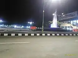 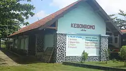 Form top to bottom: Sragen at night and Kebonromo Train Station | |
 Coat of arms | |
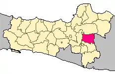 Location within Central Java | |
| Coordinates: 7.4128°S 110.9350°E | |
| Country | Indonesia |
| Region | Java |
| Province | Central Java |
| Capital | Sragen |
| Government | |
| • Regent | Kusdinar Untung Yuni Sukowati |
| • Vice Regent | Dedy Endriyatno |
| Area | |
| • Total | 941.56 km2 (363.54 sq mi) |
| Population (2019)[1] | |
| • Total | 890,518 |
| • Density | 950/km2 (2,400/sq mi) |
| Time zone | UTC+7 (IWST) |
| Area code | (+62) 271 |
| Website | sragenkab |

The famous river, Bengawan Solo flows through the fertile rice fields in the region. The archaeological excavation and UNESCO World Heritage Site Sangiran is located in Sragen.
Administrative Districts
Sragen Regency comprises twenty districts (kecamatan), tabulated below with their areas and their populations at the 2010 Census,[4] together with the latest official estimates (for mid 2019).[5] The table also includes the number of administrative villages (rural desa and urban kelurahan) in each district and its post code.
| Name | Area in km2 | Pop'n Census 2010 | Pop'n Estimate mid 2019 | No. of vill. | Post code |
|---|---|---|---|---|---|
| Kalijambe | 46.96 | 47,135 | 49,661 | 14 | 57275 |
| Plupuh | 48.36 | 42,394 | 43,196 | 16 | 57283 |
| Masaran | 44.04 | 69,319 | 74,910 | 13 | 57282 |
| Kedawung | 49.78 | 57,139 | 60,151 | 10 | 57292 |
| Sambirejo | 48.43 | 35,173 | 35,838 | 9 | 57293 |
| Gondang | 41.17 | 41,454 | 42,238 | 9 | 57254 |
| Sambungmacan | 38.48 | 43,907 | 44,738 | 9 | 57253 |
| Ngrampal | 34.40 | 36,867 | 37,563 | 8 | 57252 |
| Karangmalang | 42.98 | 62,367 | 68,612 | 10 | 57221-57222 |
| Sragen (town) | 27.27 | 66,660 | 69,665 | 8 | 57211-57216 |
| Sidoharjo | 45.90 | 50,634 | 51,590 | 12 | 57281 |
| Tanon | 51.00 | 50,631 | 51,590 | 16 | 57277 |
| Gemolong | 40.23 | 45,365 | 47,112 | 14 | 57274 |
| Miri | 53.81 | 31,994 | 32,598 | 10 | 57276 |
| Sumberlawang | 75.16 | 43,525 | 44,349 | 11 | 57272 |
| Mondokan | 49.36 | 33,350 | 33,981 | 9 | 57271 |
| Sukodono | 45.55 | 29,108 | 29,660 | 9 | 57263 |
| Gesi | 39.58 | 19,558 | 19,934 | 7 | 57262 |
| Tangen | 55.13 | 25,591 | 26,075 | 7 | 57261 |
| Jenar | 63.96 | 26,100 | 27,057 | 7 | 57256 |
| Totals | 941.56 | 858,266 | 890,518 | 208 |
Climate
Sragen has a tropical monsoon climate (Am) with moderate to little rainfall from June to September and heavy rainfall from October to May.
| Climate data for Sragen | |||||||||||||
|---|---|---|---|---|---|---|---|---|---|---|---|---|---|
| Month | Jan | Feb | Mar | Apr | May | Jun | Jul | Aug | Sep | Oct | Nov | Dec | Year |
| Average high °C (°F) | 30.8 (87.4) |
30.7 (87.3) |
31.0 (87.8) |
31.7 (89.1) |
31.4 (88.5) |
31.5 (88.7) |
31.6 (88.9) |
32.4 (90.3) |
33.4 (92.1) |
33.7 (92.7) |
32.8 (91.0) |
31.7 (89.1) |
31.9 (89.4) |
| Daily mean °C (°F) | 26.5 (79.7) |
26.5 (79.7) |
26.6 (79.9) |
27.0 (80.6) |
26.6 (79.9) |
26.1 (79.0) |
25.6 (78.1) |
26.0 (78.8) |
26.9 (80.4) |
27.6 (81.7) |
27.5 (81.5) |
26.9 (80.4) |
26.6 (80.0) |
| Average low °C (°F) | 22.2 (72.0) |
22.3 (72.1) |
22.3 (72.1) |
22.3 (72.1) |
21.8 (71.2) |
20.7 (69.3) |
19.6 (67.3) |
19.6 (67.3) |
20.5 (68.9) |
21.6 (70.9) |
22.2 (72.0) |
22.2 (72.0) |
21.4 (70.6) |
| Average rainfall mm (inches) | 305 (12.0) |
307 (12.1) |
319 (12.6) |
213 (8.4) |
149 (5.9) |
63 (2.5) |
58 (2.3) |
32 (1.3) |
52 (2.0) |
144 (5.7) |
226 (8.9) |
260 (10.2) |
2,128 (83.9) |
| Source: Climate-Data.org[6] | |||||||||||||
References
- Badanb Pusat Statistik, Jakarta, 2020.
- Biro Pusat Statistik, Jakarta, 2011.
- Badanb Pusat Statistik, Jakarta, 2020.
- Biro Pusat Statistik, Jakarta, 2011.
- Badan Pusat Statistik, Jakarta, 2020.
- "Climate: Sragen". Climate-Data.org. Retrieved 15 November 2020.
External links
| Wikimedia Commons has media related to Sragen Regency. |
Regencies and cities of Central Java | ||
|---|---|---|
Capital: Semarang | ||
| Regencies |  | |
| Cities | ||