Semarang Regency
Semarang is a regency (Indonesian: kabupaten) in Central Java province in Indonesia. It covers an area of 950.207 km2 and had a population of 930,727 at the 2010 Census[3] and 999,817 at the 2015 Census; the latest official estimate (as at 2018) is 1,040,629.[4] These figures exclude the independent cities of Semarang and Salatiga, which are administratively separate from the regency. The Regency's capital is Ungaran, which lies immediately to the south of Semarang City.
Semarang Regency
Kabupaten Semarang | |
|---|---|
| Other transcription(s) | |
 | |
 Coat of arms | |
| Motto(s): Dharmottama Satya Praja | |
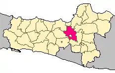 Semarang Regency within Central Java | |
 Semarang Regency Location in Indonesia | |
| Coordinates: 7°15′56″S 110°20′9″E | |
| Country | |
| Province | Central Java |
| Founded | 2 May 1547 |
| Capital | Ungaran |
| Government | |
| • Mayor | dr. H. Mundjirin ES .SpOG |
| • Vice-mayor | Ir. Warnadi MM |
| Area | |
| • Total | 950.207 km2 (366.877 sq mi) |
| Population (2018)[1] | |
| • Total | 1,040,629 |
| • Density | 1,100/km2 (2,800/sq mi) |
| [2] | |
| Time zone | UTC+7 (Indonesia Western Standard Time) |
| Area code(s) | 0274, 0298 |
| Vehicle registration | H |
| Website | semarangkab.go.id |
Geography
Administratively, Semarang Regency is bordered by Kendal Regency and Temanggung Regency in the west, Boyolali Regency and Magelang Regency in the south, Grobogan Regency and Demak Regency in the east, and the city of Semarang in the north. Salatiga City, meanwhile, forms an enclave within the regency, and is administratively separate. Geographically, it is located between 110°14′54,74″–110°39'3"E and 7°3'57"–7°30'S.[5] Semarang Regency has an area of 95,020 ha (234,800 acres), with a productive land area of 24,417 ha (60,340 acres).
Air temperature in this regency is relatively cold because it is located between 318–1,450 m above sea level. Ungaran Barat District is the lowest area, while Getasan District is the highest. In 2005 there was 97 rainy days and in 2007 was 83 rainy days. Bawen District is an area with the most rainy days (144 days) and Suruh District the least (30 days).
Demographics
Semarang Regency had a population of 1,040,629,[1] an increase of 40,812 since the 2015 census.[6] The gender ratio in 2018 is 96.55 (males per 100 females).[1]
Administrative divisions
Semarang Regency comprises nineteen districts (kecamatan), listed below with their areas and their populations at the 2010 Cemsus[7] and the recent official estimates (as at 2018). The districts are sub-divided into 208 rural villages or desa, and 27 urban villages or kelurahan.[8]
| District | Area (in km2)[9] |
Population 2010 Census |
Population 2018 Estimate[1] |
Population density 2018 { per km2) |
|---|---|---|---|---|
| Getasan | 65.796 | 47,956 | 51,399 | 781.2 |
| Tengaran | 47.296 | 64,146 | 72,207 | 1,526.7 |
| Susukan | 48.865 | 43,124 | 44,071 | 901.9 |
| Kaliwungu | 29.950 | 26,310 | 26,657 | 890.1 |
| Suruh | 64.015 | 59,640 | 60,424 | 943.9 |
| Pabelan | 47.975 | 37,256 | 40,099 | 835.8 |
| Tuntang | 56.242 | 60,392 | 66,573 | 1,183.7 |
| Banyubiru | 54.415 | 40,219 | 43,462 | 798.7 |
| Jambu | 51.627 | 36,551 | 39,583 | 766.7 |
| Sumowono | 55.630 | 29,681 | 30,904 | 598.6 |
| Ambarawa | 28.221 | 58,299 | 63,193 | 2,239.2 |
| Bandungan | 48.233 | 52,443 | 57,849 | 1,199.4 |
| Bawen | 46.570 | 53,725 | 63,437 | 1,362.2 |
| Bringin | 61.891 | 40,976 | 43,306 | 699.7 |
| Bancak | 43.846 | 19,837 | 20,098 | 431.6 |
| Pringapus | 78.352 | 49,948 | 58,380 | 745.1 |
| Bergas | 47.332 | 67,993 | 87,609 | 1,850.9 |
| West Ungaran (Ungaran Barat) |
35.960 | 74,063 | 87,182 | 2,424.4 |
| East Ungaran (Ungaran Timur) |
37.992 | 68,168 | 84,196 | 2,216.2 |
| Totals | 950.207 | 930,727 | 1,040,629 | 1,095.2 |
Tourist attractions[10]
- Budha Gaya Watugong Shrine. Budha Gaya Watugong shrine complex has great artistic value. With the height of 39 metres, it represents the highest pagoda in Indonesia. It was built in 2005, and it is located in front of Makodam IV Diponegoro Semarang. In the seven-floor building, there are some Welas Asih Goddess statues lied on its second until sixth floor, and also has 20 Kwan Im statues.
- The Indonesian Railway Museum is located on the town of Ambarawa. The museum is located on a decommissioned railway station and houses several train locomotives, carriages, and railway paraphernalia from the colonial era.
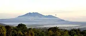
- The Gedong Songo Temple Complex are a series of temples located some 5 kilometers from the town of Bandungan, on the slopes of Mount Ungaran built in the Hindu-Buddhist era.
- Penggaron Forest. It is about 350 m (1,150 ft) above sea level with a temperature of 20–26 °C with fresh and clean air. This forest recreation site lies within 17 km from Semarang and only 2 km from Ungaran, making the area very close to urban areas. It is dominated by pine trees, though other species can also be found.
- Lake Rawa Pening is a freshwater lake located in the districts of Ambarawa, Banyubiru, Bawen, and Tuntang. It is home to a unique ecosystem made out of floating water hyacinth islands and is an important center of fisheries and birdlife in the regency.
- Tlogo Coffee Plantation. Tlogo Coffee Plantation is located in Delik Village. It is an area with a width of 415 ha (1,030 acres) and is 400–675 m above sea level. Cold weather and clean air, free from pollution, will bring enjoyable moment and beautiful panorama.
Footnotes
- "Badan Pusat Statistik Kabupaten Semarang". semarangkab.bps.go.id. Retrieved 2020-10-14.
- Badan Pusat Statistik, Jakarta, 2020.
- Biro Pusat Statistik, Jakarta, 2011.
- Badan Pusat Statistik, Jakarta, 2020.
- "Profile - SIPID - Regional Investment". Indonesia Investment Coordinating Board. Archived from the original on 2013-10-21. Retrieved 2020-10-14.
- "Indonesia: Central Java Province (Regencies and Cities) - Population Statistics, Charts and Map". citypopulation.de. Retrieved 2020-10-16.
- Biro Pusat Statistik, Jakarta, 2011.
- "BAB II GAMBARAN UMUM KABUPATEN SEMARANG DAN DESKRIPSI WILAYAH PENELITIAN" (PDF). Universitas Diponegoro.
- "Badan Pusat Statistik Kabupaten Semarang". semarangkab.bps.go.id. Retrieved 2020-10-15.
- http://www.tourism-mpu.com/central-java/en/attractionlist/8_semarang_regency
External links
- (in Indonesian) Official website
Regencies and cities of Central Java | ||
|---|---|---|
Capital: Semarang | ||
| Regencies |  | |
| Cities | ||
