Remscheid
Remscheid (German pronunciation: [ˈʁɛmʃaɪt] (![]() listen)) is a city in North Rhine-Westphalia, Germany. It is, after Wuppertal and Solingen, the third largest municipality in Bergisches Land, being located on the northern edge of the region, on the south side of the Ruhr area.
listen)) is a city in North Rhine-Westphalia, Germany. It is, after Wuppertal and Solingen, the third largest municipality in Bergisches Land, being located on the northern edge of the region, on the south side of the Ruhr area.
Remscheid | |
|---|---|
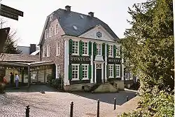 German Röntgen Museum | |
 Coat of arms | |
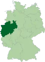
Location of Remscheid 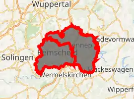
| |
 Remscheid 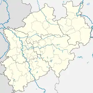 Remscheid | |
| Coordinates: 51°11′0″N 07°12′0″E | |
| Country | Germany |
| State | North Rhine-Westphalia |
| Admin. region | Düsseldorf |
| District | Urban districts of Germany |
| Government | |
| • Lord mayor | Burkhard Mast-Weisz (SPD) |
| Area | |
| • Total | 74.6 km2 (28.8 sq mi) |
| Elevation | 365 m (1,198 ft) |
| Population (2019-12-31)[1] | |
| • Total | 111,338 |
| • Density | 1,500/km2 (3,900/sq mi) |
| Time zone | UTC+01:00 (CET) |
| • Summer (DST) | UTC+02:00 (CEST) |
| Postal codes | 42801-42899 |
| Dialling codes | 02191 |
| Vehicle registration | RS |
| Website | www.remscheid.de |
Remscheid had around 109,000 inhabitants in 2015. At the end of 2019 it had 113,703 inhabitants.
Its highest point is the Brodtberg (378 m).
History
Remscheid was founded in the 12th century, but remained a small village until the 19th century. Early spellings for the city included Remissgeid (1217), Rymscheyd (1351), Reymscheyd (1487) and Rembscheid (1639). The economic growth of the entire Rhine-Ruhr region led to an increase of the population of Remscheid. Mechanical engineering and toolmaking were the main industries practised within the town. This is carried on today with the Hazet tool company which has two factories in Remscheid. Remscheid was part of the Prussian Rhine Province from 1822 to 1945.
On 31 July 1943, during the second World War, Remscheid was almost completely destroyed during a British bombing raid which caused a firestorm. This bombing raid was the final operation of RAF's Battle of the Ruhr involving 273 aircraft. During 14 and 15 April 1945, Remscheid was captured by the 78th Infantry Division (United States).[2][3]
An A-10 Thunderbolt II crashed in the city on 8 December 1988. Six people died.
Today, Remscheid comprises four boroughs, Alt-Remscheid, Remscheid-Süd, Lennep, and Lüttringhausen.
As of 31 December 2019, the city's population was 113,703, of which 92,726 (81.6%) were German citizens and 20,977 (18.4%) were non-Germans (Ausländer); of the non-German population, the top 10 nationalities represented were as follows:[4]
| Rank | Nationality | Population (31.12.2019) |
|---|---|---|
| 1 | 5,749 | |
| 2 | 3,158 | |
| 3 | 1,264 | |
| 4 | 1,187 | |
| 5 | 1,039 | |
| 6 | 866 | |
| 7 | 748 | |
| 8 | 646 | |
| 9 | 583 | |
| 10 | 493 | |
Main sights
- The Müngstener Brücke is a railway bridge crossing a valley and connecting Remscheid with the neighbouring town of Solingen. It is 107 m above the ground, making it the highest railway bridge in Germany. It was constructed in 1897 and originally named the Kaiser-Wilhelm-Brücke after Wilhelm I (whose 100th birthday would have been in 1897).
- The Eschbachtalsperre, the first dam built in Germany for the supply of drinking water is located here. It was built in 1891.
- The old city of the borough Lennep consists of 116 houses from 1756.
Notable people
- Michael Bacht (born 1947), German artist
- Peter Brötzmann, (born 1941), free jazz saxophonist, born in Remscheid.
- Gottfried Duden, (1789-1856), German writer, traveled to the United States mostly in Missouri and wrote Bericht über eine Reise nach den westlichen Staaten Nordamerikas ("Report of a journey to the western states of North America")
- Johannes Fastenrath; (1839-1908), German lawyer, writer and translator.
- Christel Frese, (born 1944), athlete (short and medium range) and 1972 olympian.
- August Gissler; (1857-1935), German treasure hunter who lived from 1889 to 1908, with brief interruptions on the Cocos Island (Costa Rica).
- Otto Jungtow; (1892-1961), German football player.
- Otto Kuhler, artist and designer of locomotives, born in Remscheid in 1894.
- Robert A. Küfner, German entrepreneur, was born in Wuppertal in 1988.
- Harry Luck, (born 1972), writer and journalist.
- Teo Otto, (1904-1968), stage designer, was born in Remscheid.
- Wolfgang von der Nahmer, (1906–1988), conductor and music educator.
- Frank Plasberg, (born 1957), German journalist, born in Remscheid.
- Caspar Georg Carl Reinwardt; (1773-1854), world-famous scientist.
- Wilhelm Röntgen, (1845-1923), discoverer of x-rays, was born in Lennep, which is today a borough of Remscheid.
- Oscar Schlitter (1838-1939), banker
- Wolfgang Seiler, (born 1940), biogeochemist and climatologist was born in Remscheid
- Christiane Soeder (born 1975), German-Austrian cyclist.
- Hans Stammreich, (1902-1969), Raman spectroscopist later living in Brazil, was born in Remscheid.
- Gustav Adolf Theill (1924–1997), composer and musicologist.
- Wolfgang Tillmans, a photographer, was born in Remscheid in 1968.
- Karl Michael Vogler, (1928-2009), actor, was born in Remscheid.
- Georg Wurth, CEO and owner of the Deutscher Hanf Verband (German Hemp Association) (DHV), the largest organization of the hemp movement in Germany was born in Remscheid in 1972.
Gallery
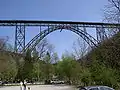 Müngstener Bridge.
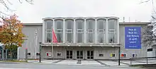
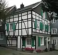 Kraspütt 3 in Lennep
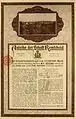 bond of the town Remscheid, issued 25. August 1922
Twin towns - sister cities
Remscheid is twinned with:[5]
References
- "Bevölkerung der Gemeinden Nordrhein-Westfalens am 31. Dezember 2019" (in German). Landesbetrieb Information und Technik NRW. Retrieved 17 June 2020.
- http://tothosewhoserved.org/usa/ss/usass01/chapter5.html
- https://archive.org/details/Lightning78thInfantry
- "Informationen der Statistikstelle: Remscheider Einwohnerinnen und Einwohner am 31. Dezember 2019" (PDF). Stadt Remscheid. pp. 6, 12. Retrieved 9 May 2020. Available on Stadt Remscheid website under "Bevölkerung und Bevölkerungsentwicklung".
- "Partnerstädte". remscheid.de (in German). Remscheid. Retrieved 28 November 2019.
External links
| Wikimedia Commons has media related to Remscheid. |
- . Encyclopædia Britannica. 16 (11th ed.). 1911. p. 419.
- German Roentgen-Museum (in German)
- Official City Website (in German)
| Authority control |
|---|