Rocca delle Penne
Rocca delle Penne is a 1501 metres high mountain in the Ligurian Prealps (part of the Ligurian Alps) in Italy.
| Rocca delle Penne | |
|---|---|
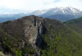 The mountain seen from Rocca Tramontina | |
| Highest point | |
| Elevation | 1,501 m (4,925 ft) [1] |
| Prominence | 122 m (400 ft) [2] |
| Coordinates | 44°06′18.8″N 07°55′56.1″E |
| Naming | |
| English translation | Feathers' cliff |
| Language of name | Italian |
| Geography | |
 Rocca delle Penne Location in the Alps | |
| Location | Liguria/Piedmont, Italy |
| Parent range | Ligurian Alps |
| Climbing | |
| First ascent | ancestral |
| Easiest route | from Colle di Caprauna |
Geography
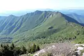
The mountain is located between the province of Imperia, in Liguria, and the province of Cuneo, in Piedmont. In the SOIUSA (International Standardized Mountain Subdivision of the Alps) it gives the name to the Dorsale della Rocca delle Penne,[3] a ridge starting from the main chain of the Alps at monte della Guardia which, heading south-east, divides the valleys Arroscia and Pennaviare/Neva.[4] The mountain is divided by monte della Guardia by the Caprauna pass (1379 m) and from the nearby rocca Tramontina (1495 m) by a saddle at 1470 m.
Access to the summit
The summit of Rocca della Penna can be accessed following unmarked traks on the ridge connecting Colle di Caprauna and rocca Tramontina. [5]
References
- Italian official map 1:25.00 of Istituto Geografico Militare (on-line on www.pcn.minambiente.it)
- key col: Colle di Caprauna (1379 m)
- Marazzi, Sergio (2005). Atlante Orografico delle Alpi. SOIUSA (in Italian). Priuli & Verlucca. p. 134. ISBN 978-88-8068-273-8.
- Carta turistica ed escursionistica - Provincia di Savona 1:50.000 map; publisher: Provincia di Savona
- Cinzia Pezzani, Sergio Grillo (2009). A piedi in Liguria (in Italian). Iter Edizioni. ISBN 9788881770113.
External links
![]() Media related to Rocca delle Penne at Wikimedia Commons
Media related to Rocca delle Penne at Wikimedia Commons
- (in Italian) Hike description on Gulliver.it: Tramontina (Rocca) da Armo per Ariolo (Monte) Castagnino (Bric) e Rocca delle Penne
