Rocky Branch (New Hampshire)
The Rocky Branch is a 13.1-mile-long (21.1 km)[1] river in the White Mountains of New Hampshire in the United States. It is a tributary of the Saco River, which flows to the Atlantic Ocean in Maine.
| Rocky Branch | |
|---|---|
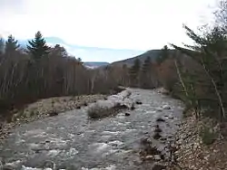 The Rocky Branch at U.S. Route 302 in Bartlett, NH | |
  | |
| Location | |
| Country | United States |
| State | New Hampshire |
| Counties | Coos, Carroll |
| Towns and townships | Cutts Grant, Sargents Purchase, Jackson, Bartlett |
| Physical characteristics | |
| Source | Presidential Range Dry River Wilderness |
| • location | Cutts Grant |
| • coordinates | 44°14′1″N 71°17′45″W |
| • elevation | 3,910 ft (1,190 m) |
| Mouth | Saco River |
• location | Bartlett |
• coordinates | 44°6′9″N 71°11′50″W |
• elevation | 550 ft (170 m) |
| Length | 13.1 mi (21.1 km) |
| Basin features | |
| Tributaries | |
| • right | Upper Stairs Brook, Lower Stairs Brook |
The Rocky Branch rises in the Presidential Range Dry River Wilderness Area of the White Mountain National Forest on the southernmost slopes of Mount Washington. The river drops rapidly to the south through a valley between Montalban Ridge (with the peaks of Mount Isolation and Stairs Mountain) to the west and the lower Rocky Branch Ridge to the east. Turning more to the southeast, the river leaves the national forest and enters the town of Bartlett, New Hampshire, where it joins the Saco River after passing under U.S. Route 302.
See also
This article is issued from Wikipedia. The text is licensed under Creative Commons - Attribution - Sharealike. Additional terms may apply for the media files.