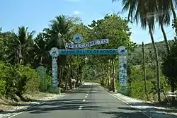
Ronda, Cebu
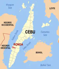
Ronda, officially the Municipality of Ronda (Cebuano: Lungsod sa Ronda; Tagalog: Bayan ng Ronda), is a 5th class municipality in the province of Cebu, Philippines. According to the 2015 census, it has a population of 20,360 people. [3]
Ronda | |
|---|---|
| Municipality of Ronda | |
 Ronda, Cebu | |
 Seal | |
 Map of Cebu with Ronda highlighted | |
OpenStreetMap 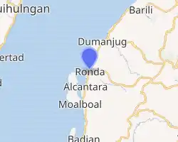
| |
.svg.png.webp) Ronda Location within the Philippines | |
| Coordinates: 10°00′01″N 123°24′34″E | |
| Country | |
| Region | Central Visayas (Region VII) |
| Province | Cebu |
| District | 7th district of Cebu |
| Founded | 1913 |
| Barangays | 14 (see Barangays) |
| Government | |
| • Type | Sangguniang Bayan |
| • Mayor | Mariano Terence Y. Blanco V |
| • Vice Mayor | Rocky T. Gabatan |
| • Representative | Peter John D. Calderon |
| • Electorate | 15,758 voters (2019) |
| Area | |
| • Total | 57.10 km2 (22.05 sq mi) |
| Elevation | 46 m (151 ft) |
| Population | |
| • Total | 20,360 |
| • Density | 360/km2 (920/sq mi) |
| • Households | 4,811 |
| Economy | |
| • Income class | 5th municipal income class |
| • Poverty incidence | 30.24% (2015)[4] |
| • Revenue | ₱62,258,066.06 (2016) |
| Time zone | UTC+8 (PST) |
| ZIP code | 6034 |
| PSGC | |
| IDD : area code | +63 (0)32 |
| Climate type | tropical rainforest climate |
| Native languages | Cebuano Tagalog |
Ronda is bordered to the north by the town of Dumanjug, to the west is the Tañon Strait, to the east is the town of Argao, and to the south is the town of Alcantara.
Barangays
Ronda comprises 14 barangays:
| PSGC | Barangay | Population | ±% p.a. | |||
|---|---|---|---|---|---|---|
| 2015 [3] | 2010 [5] | |||||
| 072239001 | Butong | 7.9% | 1,617 | 1,610 | 0.08% | |
| 072239002 | Can‑abuhon | 4.6% | 930 | 780 | 3.41% | |
| 072239003 | Canduling | 6.6% | 1,353 | 1,329 | 0.34% | |
| 072239004 | Cansalonoy | 4.2% | 846 | 709 | 3.42% | |
| 072239005 | Cansayahon | 9.6% | 1,947 | 1,799 | 1.52% | |
| 072239006 | Ilaya | 8.0% | 1,630 | 1,455 | 2.19% | |
| 072239007 | Langin | 6.2% | 1,262 | 1,251 | 0.17% | |
| 072239008 | Libo‑o | 5.9% | 1,198 | 931 | 4.92% | |
| 072239009 | Malalay | 5.7% | 1,165 | 974 | 3.47% | |
| 072239010 | Palanas | 8.5% | 1,739 | 1,504 | 2.80% | |
| 072239011 | Poblacion | 9.8% | 1,992 | 1,990 | 0.02% | |
| 072239012 | Santa Cruz | 15.8% | 3,224 | 2,768 | 2.95% | |
| 072239013 | Tupas | 2.9% | 592 | 711 | −3.43% | |
| 072239014 | Vive | 4.2% | 865 | 771 | 2.21% | |
| Total | 20,360 | 18,582 | 1.76% | |||
Climate
| Climate data for Ronda, Cebu | |||||||||||||
|---|---|---|---|---|---|---|---|---|---|---|---|---|---|
| Month | Jan | Feb | Mar | Apr | May | Jun | Jul | Aug | Sep | Oct | Nov | Dec | Year |
| Average high °C (°F) | 29 (84) |
30 (86) |
31 (88) |
32 (90) |
32 (90) |
30 (86) |
30 (86) |
30 (86) |
30 (86) |
29 (84) |
29 (84) |
29 (84) |
30 (86) |
| Average low °C (°F) | 23 (73) |
22 (72) |
23 (73) |
24 (75) |
25 (77) |
25 (77) |
24 (75) |
24 (75) |
24 (75) |
24 (75) |
24 (75) |
23 (73) |
24 (75) |
| Average precipitation mm (inches) | 42 (1.7) |
34 (1.3) |
40 (1.6) |
61 (2.4) |
124 (4.9) |
188 (7.4) |
190 (7.5) |
191 (7.5) |
189 (7.4) |
186 (7.3) |
124 (4.9) |
73 (2.9) |
1,442 (56.8) |
| Average rainy days | 10.0 | 8.5 | 9.5 | 12.8 | 22.3 | 26.8 | 28.4 | 27.9 | 27.3 | 27.6 | 20.5 | 13.1 | 234.7 |
| Source: Meteoblue [6] | |||||||||||||
Demographics
| Year | Pop. | ±% p.a. |
|---|---|---|
| 1903 | 9,662 | — |
| 1918 | 11,192 | +0.98% |
| 1939 | 11,936 | +0.31% |
| 1948 | 11,563 | −0.35% |
| 1960 | 10,565 | −0.75% |
| 1970 | 11,535 | +0.88% |
| 1975 | 12,006 | +0.81% |
| 1980 | 12,939 | +1.51% |
| 1990 | 15,264 | +1.67% |
| 1995 | 16,561 | +1.54% |
| 2000 | 16,808 | +0.32% |
| 2007 | 17,214 | +0.33% |
| 2010 | 18,582 | +2.82% |
| 2015 | 20,360 | +1.76% |
| Source: Philippine Statistics Authority [3] [5] [7][8] | ||

Poblacion
References
- Municipality of Ronda | (DILG)
- "Province: Cebu". PSGC Interactive. Quezon City, Philippines: Philippine Statistics Authority. Retrieved 12 November 2016.
- Census of Population (2015). "Region VII (Central Visayas)". Total Population by Province, City, Municipality and Barangay. PSA. Retrieved 20 June 2016.
- "PSA releases the 2015 Municipal and City Level Poverty Estimates". Quezon City, Philippines. Retrieved 12 October 2019.
- Census of Population and Housing (2010). "Region VII (Central Visayas)". Total Population by Province, City, Municipality and Barangay. NSO. Retrieved 29 June 2016.
- "Ronda: Average Temperatures and Rainfall". Meteoblue. Retrieved 10 May 2020.
- Censuses of Population (1903–2007). "Region VII (Central Visayas)". Table 1. Population Enumerated in Various Censuses by Province/Highly Urbanized City: 1903 to 2007. NSO.
- "Province of Cebu". Municipality Population Data. Local Water Utilities Administration Research Division. Retrieved 17 December 2016.
External links
Places adjacent to Ronda, Cebu | ||||||||||
|---|---|---|---|---|---|---|---|---|---|---|
| ||||||||||
Cebu City (capital) | |
| Municipalities |
|
| Component cities | |
| Highly urbanized cities | (Administratively independent from the province but grouped under Cebu by the Philippine Statistics Authority. However, qualified voters in Mandaue are allowed to vote in elections for Cebu provincial officials by virtue of Republic Act No. 6641, in accordance with Section 452-c of the Local Government Code of 1991.) |
| Authority control |
|---|
This article is issued from Wikipedia. The text is licensed under Creative Commons - Attribution - Sharealike. Additional terms may apply for the media files.